Tomasee
| Tomasee Lai da Tuma | |
|---|---|
 | |
| Location | Grisons |
| Coordinates | 46°37′57″N 8°40′20″E / 46.63250°N 8.67222°ECoordinates: 46°37′57″N 8°40′20″E / 46.63250°N 8.67222°E |
| Primary inflows | Rein da Tuma |
| Primary outflows | Rein da Tuma |
| Basin countries | Switzerland |
| Surface area | 2.5 ha |
| Surface elevation | 2345 m |
Tomasee (Romansh: Lai da Tuma or Lag da Toma) is a lake at the northern face of Piz Badus, above the village of Tschamut in Grisons, Switzerland. Its surface area is 2.5 ha.
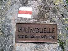
It is the source of the Anterior Rhine and is deemed to be the official source of the Rhine (the source of the Posterior Rhine is above Hinterrhein, Switzerland, at 46°29′56″N 9°03′54″E / 46.499°N 9.065°E).
It is possible to reach the lake on a path from Oberalp Pass, suitable for most walkers although still a mountain trail.[1]
External links
 Media related to Tomasee at Wikimedia Commons
This article is issued from Wikipedia - version of the 10/4/2016. The text is available under the Creative Commons Attribution/Share Alike but additional terms may apply for the media files.