Lavanda, Crimea
| Lavanda Лаванда | |
|---|---|
| Rural settlement (Ukraine) | |
|
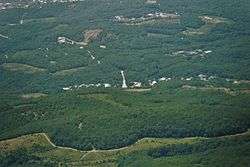
View of Lavanda from above. | |
.svg.png) Lavanda Location of Lavanda in Crimea | |
| Coordinates: RU 44°44′37″N 34°22′16″E / 44.74361°N 34.37111°ECoordinates: RU 44°44′37″N 34°22′16″E / 44.74361°N 34.37111°E | |
| Country | Russia/Ukraine[1] |
| Republic | Crimea |
| Municipality | Alushta Municipality |
| Area[2] | |
| • Total | 1.2 km2 (0.5 sq mi) |
| Elevation[3] | 460 m (1,510 ft) |
| Population (2014) | |
| • Total | 206 |
| • Density | 170/km2 (440/sq mi) |
| Time zone | MSK (UTC+4) |
| Postal code | 98530 |
| Area code | +380 6560 |
| Website | http://rada.gov.ua/ |
Lavanda (Ukrainian: Лаванда; Russian: Лаванда) is a rural settlement (Ukraine) in the Alushta Municipality of the Autonomous Republic of Crimea, a territory recognized by a majority of countries as part of Ukraine and annexed by Russia as the Republic of Crimea.[4] The word literally means "lavender."
Lavanda is located on Crimea's southern shore at an elevation of 460 metres (1,510 ft).[3] It is administratively subordinate to the Luchyste Village Council.[2] Its population was 177 in the 2001 Ukrainian census.[4] Current population: Population: 206 (2014 Census).[5] The M18 highway runs near the settlement.
References
- ↑ This place is located on the Crimean Peninsula, most of which is the subject of a territorial dispute between Russia and Ukraine. According to the political division of Russia, there are federal subjects of the Russian Federation (the Republic of Crimea and the federal city of Sevastopol) located on the peninsula. According to the administrative-territorial division of Ukraine, there are the Ukrainian divisions (the Autonomous Republic of Crimea and the city with special status of Sevastopol) located on the peninsula.
- 1 2 "Village Luchistoe". who-is-who.ua (in Russian). Ukrainian Confederation of Journalists. Retrieved 16 August 2014.
- 1 2 "Lavanda (Crimea region)". weather.in.ua. Retrieved 16 August 2014.
- 1 2 "Lavanda, Autonomous Republic of Crimea, City of Alushta". Regions of Ukraine and their Structure (in Ukrainian). Verkhovna Rada of Ukraine. Retrieved 16 August 2014.
- ↑ Russian Federal State Statistics Service (2014). "Таблица 1.3. Численность населения Крымского федерального округа, городских округов, муниципальных районов, городских и сельских поселений" [Table 1.3. Population of Crimean Federal District, Its Urban Okrugs, Municipal Districts, Urban and Rural Settlements]. Федеральное статистическое наблюдение «Перепись населения в Крымском федеральном округе». ("Population Census in Crimean Federal District" Federal Statistical Examination) (in Russian). Federal State Statistics Service. Retrieved January 4, 2016.
| Cities | ||
|---|---|---|
| Urban-type settlements | ||
| Villages | ||
| Rural settlements |
| |
This article is issued from Wikipedia - version of the 2/26/2016. The text is available under the Creative Commons Attribution/Share Alike but additional terms may apply for the media files.