Ledo Road


|
|
The Ledo Road (Hindi: लेडो रोड, Burmese: လီဒိုလမ်းမကြီး, Chinese: 中印公路) (from Ledo, Assam, India to Kunming, Yunnan, China) was built during World War II so that the Western Allies could supply the Chinese as an alternative to the Burma Road (which had been cut by the Japanese in 1942). It was renamed the Stilwell Road, after General Joseph Stilwell of the U.S. Army, in early 1945 at the suggestion of Chiang Kai-shek. It passes through the Burmese towns of Shingbwiyang, Myitkyina and Bhamo in Kachin state.[1]
In the 19th century, British railway builders had surveyed the Pangsau Pass, which is 1,136 metres (3,727 feet) high on the India-Burma border, on the Patkai crest, above Nampong, Arunachal Pradesh (then part of Assam). They concluded that a track could be pushed through to Burma and down the Hukawng Valley. Although the proposal was dropped, the British prospected the Patkai Range for a road from Assam into northern Burma. British engineers had surveyed the route for a road for the first 130 kilometres (80 miles). After the British had been pushed back out of most of Burma by the Japanese, building this road became a priority for the United States. After Rangoon was captured by the Japanese and before the Ledo Road was finished, the majority of supplies to the Chinese were delivered via airlift over the eastern end of the Himalayan Mountains known as the Hump.
Of the 1,726 kilometres (1,072 mi) long road, 1,033 kilometres (642 mi) is in Burma and 632 kilometres (393 mi) is in China with the remainder in India.[2]
After the war, the road fell into disuse. In 2010, the BBC reported, "Much of the road has been swallowed up by jungle."[2]
Construction
On 1 December 1942, British General Sir Archibald Wavell, the supreme commander of the Far Eastern Theatre, agreed with American General Stilwell to make the Ledo Road an American NCAC operation. The Ledo Road was intended to be the primary supply route to China and was built under the direction of General Stilwell from the railhead at Ledo (Assam, India)[3] to Mong-Yu road junction where it joined the Burma Road. From there trucks could continue on to Wanting on the Chinese frontier, so that supplies could be delivered to the reception point in Kunming, China. Stilwell's staff estimated that the Ledo Road route would supply 65,000 tons of supplies per month, greatly surpassing tonnage then being airlifted over the Hump to China.[4] General Claire Lee Chennault, the USAAF Fourteenth Air Force commander, thought the projected tonnage levels were overly optimistic and doubted that such an extended network of trails through difficult jungle could ever match the amount of supplies that could be delivered with modern cargo transport aircraft.[5]
The road was built by 15,000 American soldiers (60 percent of whom were African-Americans) and 35,000 local workers at a cost of US$150 million. 1,100 Americans died during the construction, as well as many more locals.[6] As most of Burma was in Japanese hands it was not possible to acquire information as to the topography, soils, and river behaviour before construction started. This information had to be acquired as the road was constructed.
General Stilwell had organized a 'Service of Supply' (SOS) under the command of Major General Raymond A. Wheeler, a high-profile US Army engineer and assigned him to look after the construction of the Ledo Road. Major General Wheeler, in turn, assigned responsibility of base commander for the road construction to Colonel John C. Arrowsmith. Later, he was replaced by Colonel Lewis A. Pick, an expert US Army engineer.
Work started on the first 166 km (103 mi) section of the road in December 1942, followed a steep, narrow trail through territory from Ledo, across the Patkai Range through the Pangsau Pass, nicknamed "Hell Pass" for its difficulty, and down to Shingbwiyang, Burma. Sometimes rising as high as 1,400 m (4,600 ft), the road required the removal of earth at the rate of 1,800 cubic metres per kilometre (100,000 cubic feet per mile). Steep gradients, hairpin curves and sheer drops of 60 m (200 ft), all surrounded by a thick rain forest was the norm for this first section. The first bulldozer reached Shingbwiyang on 27 December 1943, three days ahead of schedule.
The building of this section allowed much-needed supplies to flow to the troops engaged in attacking the Japanese 18th Division, which was defending the northern area of Burma with their strongest forces around the towns of Kamaing, Mogaung, and Myitkyina. Before the Ledo road reached Shingbwiyang, Allied troops (the majority of whom were American-trained Chinese divisions of the X Force) had been totally dependent on supplies flown in over the Patkai Range. As the Japanese were forced to retreat south, the Ledo Road was extended. This was made considerably easier from Shingbwiyang by the presence of a fair weather road built by the Japanese, and the Ledo Road generally followed the Japanese trace. As the road was built, two 10 cm (4 in) fuel pipe lines were laid side-by-side so that fuel for the supply vehicles could be piped instead of trucked along the road.
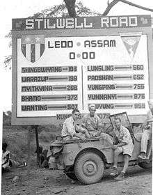
After the initial section to Shingbwiyang, more sections followed: Warazup, Myitkyina, and Bhamo, 600 km (370 mi) from Ledo. At that point the road joined a spur of the old Burma road and, although improvements to further sections followed, the road was passable. The spur passed through Namkham 558 km (347 mi) from Ledo and finally at the Mong-Yu road junction, 748 km (465 mi) from Ledo, the Ledo Road met the Burma Road. To get to the Mong-Yu junction the Ledo Road had to span 10 major rivers and 155 secondary streams, averaging one bridge every 4.5 km (2.8 mi).
For the first convoys, if they turned right, they were on their way to Lashio 160 km (99 mi) to the south through Japanese-occupied Burma. If they turned left, Wanting lay 100 km (60 mi) to the north just over the China-Burma border. However, by late 1944, the road still did not reach China; by this time, tonnage airlifted over the Hump to China had significantly expanded with the arrival of more modern transport aircraft.
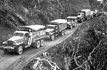
In late 1944, barely two years after Stilwell accepted responsibility for building the Ledo Road, it connected to the Burma Road though some sections of the road beyond Myitkyina at Hukawng Valley were under repair due to heavy monsoon rains. It became a highway stretching from Assam, India to Kunming, China 1,736 km (1,079 mi) length. On 12 January 1945, the first convoy of 113 vehicles, led by General Pick, departed from Ledo; they reached Kunming, China on 4 February 1945. In the six months following its opening, trucks carried 129,000 tons of supplies from India to China.[7] Twenty-six thousand trucks that carried the cargo (one way) were handed over to the Chinese.[7]
As General Chennault had predicted, supplies carried over the Ledo Road at no time approached tonnage levels of supplies airlifted monthly into China over the Hump.[8] The road, however, complemented the airlift. The capture of the Myitkyina airstrip enabled the Air Transport Command "to fly a more southerly route without fear of Japanese fighters, thus shortening and flattening the Hump trip with astonishing results."[9] In July 1943 the air tonnage was 5,500 rising to 8,000 in September and 13,000 in November.[10] After the capture of Myitkyina deliveries jumped from 18,000 tons in June 1944 to 39,000 in November 1944.[9]
In July 1945, the last full month before the end of the war, 71,000 tons of supplies were flown over the Hump, compared to only 6,000 tons using the Ledo Road; the airlift operation continued in operation until the end of the war, with a total tonnage of 650,000 tons compared to 147,000 for the Ledo Road.[5][8] By the time supplies were flowing over the Ledo Road in large quantities, operations in other theaters had shaped the course of the war against Japan.[4]
When flying over the Hukawng Valley during the monsoon, Mountbatten asked his staff the name of the river below them. An American officer replied, "That's not a river, it's the Ledo Road."[11]
American Army units assigned to the Ledo Road
The units initially assigned to the initial section were:[12]
- 45th Engineer General Service Regiment (An African-American Unit)
- 823rd Aviation Engineer Battalion (EAB) (An African-American Unit)
In 1943 they were joined by:
- 848th EAB (An African-American Unit)
- 849th EAB (An African-American Unit)
- 858th EAB (An African-American Unit)
- 1883rd EAB (An African-American Unit)
- 236th Combat Engineer Battalion
From the middle of April until the middle of May 1944 Company A of the 879th Airborne Engineer Battalion worked 24 hours a day on the Ledo Road, construction of their base camp and Shingbwiyang airfield, before deploying to Myitkyina to improve the facilities of an old British airfield recently recaptured from the Japanese.[13][14]
Work continued through 1944 in late December it was opened for the transport of logistics. In January 1945, four of the black EABs (along with three white battalions) continued working on the now renamed Stilwell Road, improving and widening it. Indeed, one of these African American units was assigned the task of improving the road that extended into China.[12]
Comments on the construction of the road
Winston Churchill called the project "an immense, laborious task, unlikely to be finished until the need for it has passed".
The British Field Marshal William Slim who commanded the British Fourteenth Army in India/Burma wrote of the Ledo Road:
I agreed with Stilwell that the road could be built. I believed that, properly equipped and efficiently led, Chinese troops could defeat Japanese if, as would be the case with his Ledo force, they had a considerable numerical superiority. On the engineering side I had no doubts. We had built roads over country as difficult, with much less technical equipment than the Americans would have. My British engineers, who had surveyed the trace for the road for the first eighty miles [130 km], were quite confident about that. We were already, on the Central front, maintaining great labour forces over equally gimcrack lines of communication. Thus far Stilwell and I were in complete agreement, but I did not hold two articles of his faith. I doubted the overwhelming war-winning value of this road, and, in any case, I believed it was starting from the wrong place. The American amphibious strategy in the Pacific, of hopping from island to island would, I was sure, bring much quicker results than an overland advance across Asia with a Chinese army yet to be formed. In any case, if the road was to be really effective, its feeder railway should start from Rangoon, not Calcutta.— William Slim.[15]
Post World War II
After Burma was liberated, the road gradually fell into disrepair. In 1955 the Oxford-Cambridge Overland Expedition drove from London to Singapore and back. They followed the road from Ledo to Myitkyina and beyond (but not to China). The book First Overland written about this expedition by Tim Slessor (1957) reported that bridges were down in the section between Pangsau Pass and Shingbwiyang. In February 1958 the Expedition of Eric Edis and his team also used the road from Ledo to Myitkyina en route to Rangoon, Singapore and Australia. Ten months later they returned in the opposite direction. In his book about this expedition The Impossible Takes a Little Longer Edis (2008) reports that they have removed a yellow sign with India/Burma on it from the Indian/Burmese border and that they have donated it to the Imperial War Museum in London. For many years, travel into the region was also restricted by the Government of India. Because of continuous clashes between insurgents (who were seeking shelter in Burma) and the Indian Armed Forces, India imposed harsh restrictions between 1962 and the mid-1990s on travel into Burma.
Since an improvement in relations between India and Myanmar, travel has improved and tourism has begun near Pangsayu Pass (at the Lake of No Return). Recent attempts to travel the full road have met with varying results. At present the Nampong-Pangsau Pass section is passable in four-wheel drive vehicles. The road on the Burmese side is now reportedly fit for vehicular traffic. Donovan Webster reached Shingbwiyang on wheels in 2001, and in mid-2005 veterans of the Burma Star Association were invited to join a "down memory lane" trip to Shingbwiyang organised by a politically well-connected travel agent. These groups successfully travelled the road but none made any comment on the political or human rights situation on Burma afterward.
Burmese from Pangsau village saunter nonchalantly across Pangsau Pass down to Nampong in India for marketing, for the border is open despite the presence of insurgents on both sides. There are Assam Rifles and Burma Army posts at Nampong and Pangsau respectively. But the rules for locals in these border areas do not necessarily apply to westerners. The governments of both countries keep careful watch on the presence of westerners in the border areas and the land border is officially closed. Those who cross without permission risk arrest or problems with smugglers/insurgents in the area.
Current state
In recent years, the Burmese government has focused on the reconstruction of the Ledo Road as an alternative to the existing Lashio-Kunming Burma Road. The Chinese government completed construction of the Myitkyina-Kambaiti section in 2007 and the Rangoon-based Yuzana Company started constructing the section between Myitkyina and Tanai. India's Government, however, fears that the road may be useful to millitants in North East India who have hideouts in Myanmar.[16][17][18]
In 2010 the BBC described the road: "Much of the road has been swallowed up by jungle. It is barely passable on foot and is considered too dangerous to use by many because of the presence of Burmese and Indian ethnic insurgents in the area....At present the road from Myitkyina to the Chinese border - along with the brief Indian section - is usable."[2]
In 2015, it was not possible to travel the Ledo Road due to border restrictions.[19] In 2015, the Chinese section from Namyun village to Pangsau Pass in Burma was a "heavily rutted muddy track" through the jungle according to a BBC correspondent.[19]
See also
- The Ledo Road. General Joseph W. Stilwell's Highway to China.
- Northeast Indian Railways during World War II. The Allies had problems supplying the depots at Ledo with all the logistical support needed by the Northern Front and the Chinese National Army.
- South-East Asian Theatre of World War II
- Pangsau Pass
- South East Asia Command
- Changlang
- The Stilwell Road (film)
Notes
- ↑ Bhaumik, Subir (11 August 2009). "India not to reopen key WWII road". BBC News. Retrieved 2010-05-07.
- 1 2 3 Bhaumik, Subir. "Will the famous Indian WWII Stilwell Road reopen?". BBC News. Retrieved 11 March 2016.
- ↑ location of Ledo
- 1 2 Sherry, Mark D., China Defensive 1942-1945, United States Army Center of Military History, CBI Background. Chapter: "China Defensive"
- 1 2 Xu, p. 191
- ↑ Sankar, Anand (14 February 2009). "On the road to China". Business Standard. Retrieved 2015-05-16.
- 1 2 American Embassy in China, U.S. Embassy Marks 60th Anniversary of Ledo Road, U.S. Embassy Press Briefing and Release, 2 February 2005
- 1 2 Schoenherr Steven,The Burma Front, History Department at the University of San Diego
- 1 2 Tuchman, Barbara W. (1971). Stilwell and the American Experience in China, 1911-45. Macmillan. p. 484
- ↑ Tuchman, Barbara W. (1971). Stilwell and the American Experience in China, 1911-45. Macmillan. p. 376
- ↑ Moser, p. 139
- 1 2 Staff. EAB in China-Burma-India, National Museum of the U.S. Air Force, Retrieved 2008-10-01
- ↑ 879th Airborne Engineers Official Battalion History declassified NND957710
- ↑ Zaitsoff, Mark P. (7 September 2010). Goldblatt, Gary, ed. "879th Engineer Battalion (aviation):Engineers by Glider to Myitkyina – Company A, 879th Engineers 17 May 1944". CBI Order of Battle, linages and history. Retrieved March 2012. Check date values in:
|access-date=(help) - ↑ Slim, start of Chapter XII: The Northern Front
- ↑ Staff. Resident's homes on Ledo Road to move back 20 feet, Kachin News Group (KNG), 7 August 2008
- ↑ Human Rights Documentation Unit, Burma Human Rights Yearbook 2007, National Coalition Government of the Union of Burma, September 2008. p. 214
- ↑ http://ibnlive.in.com/news/stilwell-road-indochina-road-to-peace/163192-3.html
- 1 2 Coomes, Phil (10 August 2015). "The Stilwell Road 70 years on". BBC. Retrieved 11 March 2016.
References
- Baruah, Sri Surendra. The Stilwell Road a historical review on the website of Tinsukia District in India.
- Hindah, Radhe. (NIC Changlang District Unit), A profile of Changlang District: Stilwell Road, the website of the Changlang District in India. (a mirror) A History of the road and the proposed reopening as International Highway.
- Moser, Don (1978). China, Burma, India Time-Life Books
- Slim, William Defeat into Victory, ISBN 1-56849-077-1. Chapter XII: The Northern Front
- Staff. US Mil In China-Burma-India on the website of the National Museum of the United States Air Force
- Weidenburner, Carl Warren. Ledo Road Signs
- Xu, Guangqiu. War Wings: The United States and Chinese Military Aviation, 1929-1949, Greenwood Publishing Group (2001), ISBN 0-313-32004-7, ISBN 978-0-313-32004-0
Further reading
- Allen, Louis. Burma: The Longest War 1941-1945, Cassell; New edition (2000) ISBN 1-84212-260-6.
- Choudhuri, Atonu. Monumental neglect of war graves - Discovered in 1997, Jairampur cemetery gets entangled in red tape, Calcutta Telegraph, 29 January 2008
- Cochrane, S. Stilwell's Road www.chindit.net (1999–2003)
- Edis, Eric (2008). The Impossible Takes a Little Longer, Lightning Source UK Ltd (2008), ISBN 978-1-4092-0301-8.
- Gardener, S. Neal, A facsimile of the Ex-CBI Roundup July 1954 Issue, pg 20. Also additional photos of unit patches website CBI GardenerWorld
- Jenkins, Mark The Ghost Road Outside Magazine October 2003
- Khaund, Surajit. Kalam urged to reopen Stillwell Road to Reach Burma (archived from original) Mizzima News (www.mizzima.com) 28 March 2005. "Guwahati: Pursuing to reach the Burma market in the wake of improved bilateral relation, Indian Minister of state for external Affairs Bijay Krishna Handique has submitted a memorandum to President APJ Abdul Kalam for reopening of the famous Stilwell Road which connects India, Burma and China" (backup site)
- The Ledo Road; "Pick's Pike" follows Stilwell's advance in Burma Adapted for the internet from Life Magazine 14 August 1944 issue. (One of many facsimiles of original documents about the CBI on the Website of by Carl W. Weidenburner)
- A war-time engineering miracle (backup) in The Myanmar Times Vol. 5, No. 99, 21–27 January 2002
- McRae, Jr., Bennie J. 858th Engineer Aviation Battalion LWF PUBLICATIONS
- Latimer Jon, Burma: The Forgotten War, John Murray, (2004). ISBN 0-7195-6576-6. Chapter 13: 'Stilwell in the North'
- Reagan, Ronald (narraor). Stilwell Road (1945) A 51-minute documentary that, describes why and how the Ledo Road was built.
- Seay, Geraldine. African Americans and the Ledo Stilwell Road. ""
- Slessor, Tim (1957) . First Overland, Signal Books Ltd (2005), ISBN 1-904955-14-2.
- Tun, Khaing Recent photos of Ledo Road website of CBI Expeditions
- Webster, Donovan. "The Burma Road: The Epic Story of the China-Burma-India Theater in World War" by ; Farrar, Straus and Giroux (US), Hardback (2003), ISBN 0-374-11740-3 also Pan (UK), Paperback (2005), ISBN 0-330-42703-2
- Weidenburner, Carl Warren. The Ledo Road
- Weidenburner, Carl Warren. Mile posts and time line
- Los Angeles Times: Burma's Stilwell Road: A backbreaking World War II project is revived.
| Wikimedia Commons has media related to Ledo Road. |
Coordinates: 27°41′18″N 95°55′57″E / 27.68839°N 95.93262°E