Lefktro
| Lefktro Λεύκτρο | |
|---|---|
|
View of Kardamyli | |
 Lefktro | |
|
Location within the regional unit 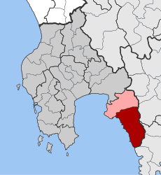 | |
| Coordinates: 36°51′N 22°16′E / 36.850°N 22.267°ECoordinates: 36°51′N 22°16′E / 36.850°N 22.267°E | |
| Country | Greece |
| Administrative region | Peloponnese |
| Regional unit | Messenia |
| Municipality | West Mani |
| Districts | 19 |
| • Municipal unit | 222.981 km2 (86.093 sq mi) |
| Highest elevation | 1,300 m (4,300 ft) |
| Lowest elevation | 0 m (0 ft) |
| Population (2011)[1] | |
| • Municipal unit | 4,699 |
| • Municipal unit density | 21/km2 (55/sq mi) |
| Time zone | EET (UTC+2) |
| • Summer (DST) | EEST (UTC+3) |
| Postal code | 24022 |
| Area code(s) | 2721 |
| Vehicle registration | KM |
| Website | www.lefktro.gr/english/ |
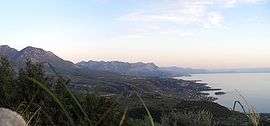
Lefktro (Greek: Λεύκτρο) is a village and a former municipality in Messenia, Peloponnese, Greece. Since the 2011 local government reform it is part of the municipality West Mani, of which it is a municipal unit.[2] The municipal unit has an area of 222.981 km2.[3] Its population is 4,699 (2011). The seat of the municipality was in Kardamyli. The village Lefktro is located above the larger village of Stoupa. Also known as Choriadaki (little town), it contains some restored Mani towers and a few newer houses, virtually all built in the traditional style, of local stone. A ten-minute walk to the sea and Stoupa's beach, it is on the slopes leading up to the Taygetos mountains.
Local communities
| Community | English | Greek | Population (2011) |
|---|---|---|---|
| 1 | Agios Nikolaos | Άγιος Νικόλαος | 331 |
| 2 | Agios Nikon | Άγιος Νίκων | 79 |
| 3 | Exochori | Εξωχώρι | 359 |
| 4 | Thalames | Θαλάμες | 77 |
| 5 | Kardamyli | Καρδαμύλη | 417 |
| 6 | Karyovouni | Καρυοβούνι | 42 |
| 7 | Kastania | Καστανέα | 102 |
| 8 | Lagkada | Λαγκάδα | 111 |
| 9 | Milea | Μηλέα | 153 |
| 10 | Neochori | Νεοχώρι | 1,399 |
| 11 | Nomitsi | Νομίτσι | 105 |
| 12 | Platsa | Πλάτσα | 346 |
| 13 | Proastio | Προάστιο | 364 |
| 14 | Prosilio | Προσήλιο | 171 |
| 15 | Pyrgos | Πύργος | 95 |
| 16 | Rigklia | Ρίγκλια | 214 |
| 17 | Saidona | Σαϊδόνα | 47 |
| 18 | Trachila | Τραχήλα | 174 |
| 19 | Tseria | Τσέρια | 192 |
| Total (2011) | 4,699 | ||
References
- ↑ "Απογραφή Πληθυσμού - Κατοικιών 2011. ΜΟΝΙΜΟΣ Πληθυσμός" (in Greek). Hellenic Statistical Authority.
- ↑ Kallikratis law Greece Ministry of Interior (Greek)
- ↑ "Population & housing census 2001 (incl. area and average elevation)" (PDF) (in Greek). National Statistical Service of Greece.
This article is issued from Wikipedia - version of the 12/2/2016. The text is available under the Creative Commons Attribution/Share Alike but additional terms may apply for the media files.