Lepenac
| Lepenac (Lepenci, Лепенац, Лепенец) | |
|---|---|
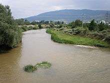 Lepenac through Macedonia | |
| Country | Kosovo, Macedonia |
| Basin | |
| Main source |
Kodža Balkan mountain, Kosovo[lower-alpha 1] 1,820 m (5,970 ft) (source), 262 m (860 ft) (mouth) |
| River mouth | Vardar, at Skopje, Macedonia |
| Basin size | 770 km2 (300 sq mi) |
| Physical characteristics | |
| Length | 75 km (47 mi) |
The Lepenac (Albanian: Lepenci ; Macedonian: ![]() Лепенец ; Serbian: Лепенац , Lepenac) is a river in southern Kosovo[lower-alpha 1] and northern Macedonia, a 75 km (47 mi) long left tributary to the Vardar river.
Лепенец ; Serbian: Лепенац , Lepenac) is a river in southern Kosovo[lower-alpha 1] and northern Macedonia, a 75 km (47 mi) long left tributary to the Vardar river.
Sirinić
The Lepenac springs out on the Kodža Balkan mountain, east of the city of Prizren, Kosovo, at an altitude of 1,820 m (5,971 ft). It flows eastward, into the župa of Sirinić, between the Žar mountain from the north and alongside the northern slopes of the Šar Mountains from the south. From the Šar Mountains it receives many small tributaries, most notably the Suva reka, as it passes next to the villages of Sevce and Jazhincë, the ski resort of Brezovica and a small town and regional center of Štrpce.
The Lepenac continues between the Šar Mountains from the south and Nerodimka mountain from the north, next to the villages of Biti e Poshtëme, Gotovushë, Brod and Doganaj, where the river makes an elbow turn to the south entering the Kosovo field.
Veliko Kosovo and Kačanik gorge
For several kilometers the Lepenac flows parallel to the Nerodimka river, flows next to the villages of Kovaçefc and Bob, and receives its major tributary the Nerodimka from the left at the town of Kačanik, at the beginning of the Kačanik gorge.
The gorge, as the narrowest part of the Lepenac river valley, is located between the Šar Mountains on the west and Skopska Crna Gora on the east and connects the Kosovo field and Skopje depressions. The gorge is 23 km (14 mi) long, carved in the limestone and slate terrain. Higher parts of the gorge are actually formed by the ancient outflow of the now extinct lake. The village of Pustenik and small town of Đeneral Janković are located in the gorge. After Đeneral Janković, the Lepenac becomes a border river between Kosovo and Macedonia, before it leaves the gorge after the village of Seçishtë and leaves Kosovo after the course of 60 km (37 mi).
Skopje depression
For the remaining 15 km (9 mi), the Lepenac flows through the low Skopje depression, part of the composite valley of the river Vardar. Immediately entering the Greater Skopje area, it receives several small streams from the left, from the Skopska Crna Gora mountain. It passes next to the ruins of the ancient city of Scupi, but has no major settlements on its Macedonian course, before it reaches the northern suburbs of Skopje, Bardovci and Novo Selo, and empties into the Vardar at the Skopje's northern borough of Gjorče Petrov at an altitude of 262 m (860 ft).
Characteristics
The Lepenac belongs to the Aegean Sea drainage basin, with its own drainage area of 770 km2 (297 sq mi) (695 km2 or 268 sq mi in Kosovo, 75 km2 or 29 sq mi in Macedonia). It is not navigable.
The Kačanik gorge is a route for the both road and railway Kraljevo-Priština-Skopje.
The river has a potential for hydroelectrical production, but even though being a part of the former Ibar-Lepenac Hydrosystem project, it is not much used, either for energy production or irrigation.
The Lepenac was a part of the artificial bifurcation, as the Nerodimka connected both Lepenac and Sitnica rivers via a canal, thus connecting Aegean and Black Sea drainage basins, but the canal was covered after the World War II.
Notes and references
Notes:
- 1 2 Kosovo is the subject of a territorial dispute between the Republic of Kosovo and the Republic of Serbia. The Republic of Kosovo unilaterally declared independence on 17 February 2008, but Serbia continues to claim it as part of its own sovereign territory. The two governments began to normalise relations in 2013, as part of the Brussels Agreement. Kosovo has received recognition as an independent state from 110 out of 193 United Nations member states.
References:
- Mala Prosvetina Enciklopedija, Third edition (1985); Prosveta; ISBN 86-07-00001-2
- Jovan Đ. Marković (1990): Enciklopedijski geografski leksikon Jugoslavije; Svjetlost-Sarajevo; ISBN 86-01-02651-6
Coordinates: 42°01′N 21°24′E / 42.017°N 21.400°E