Lewis River (Washington)
| Lewis River | |
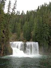
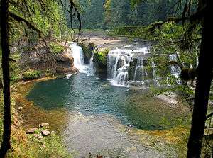 Lower Falls of the Lewis River | |
| Name origin: A. Lee Lewis, early settler | |
| Country | United States |
|---|---|
| State | Washington |
| County | Skamania, Clark, and Cowlitz |
| Source | Mount Adams |
| - location | Cascade Range, Skamania County, Washington |
| - elevation | 7,194 ft (2,193 m) [1] |
| - coordinates | 46°13′28″N 121°31′44″W / 46.22444°N 121.52889°W [2] |
| Mouth | Columbia River |
| - location | opposite St. Helens, Oregon, and on the border between Cowlitz and Clark counties, Washington |
| - elevation | 10 ft (3 m) [2] |
| - coordinates | 45°51′04″N 122°46′49″W / 45.85111°N 122.78028°WCoordinates: 45°51′04″N 122°46′49″W / 45.85111°N 122.78028°W [2] |
| Length | 95 mi (153 km) [3] |
| Basin | 1,046 sq mi (2,709 km2) [4] |
| Discharge | for mouth (average); max and min at Ariel, WA |
| - average | 6,125 cu ft/s (173 m3/s) [5] |
| - max | 129,000 cu ft/s (3,653 m3/s) |
| - min | 807.2 cu ft/s (23 m3/s) |
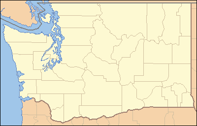 Location of the mouth of the Lewis River in Washington | |
The Lewis River is a tributary of the Columbia River, about 95 miles (153 km) long, in southwestern Washington in the United States. It drains part of the Cascade Range north of the Columbia River. The drainage basin of the Lewis River covers about 1,046 square miles (2,709 km2).[4] The river's mean annual discharge is about 6,125 cubic feet per second (173.4 m3/s).[5] Unlike nearby Lewis County and Fort Lewis the Lewis River was not named for Meriwether Lewis, but rather for A. Lee Lewis, an early settler who homesteaded near the mouth of the river.[6]
Course
The Lewis River rises in the Cascades in northeastern Skamania County, high on the west flank of Mount Adams, approximately 75 miles (121 km) northeast of Portland, Oregon. It flows generally southwest through Gifford Pinchot National Forest, across central Skamania County, passing south of Mount St. Helens. It forms the boundary, along the Dark Divide on its north side, between Cowlitz County, to the north, and Clark County, to the south. Towns along the river include Cougar, Ariel, and Woodland. In its lower 10 miles (16 km), it turns sharply south, then west, and enters the Columbia from the east, opposite St. Helens, Oregon, approximately 15 miles (24 km) north of Vancouver, Washington. The mouth of the Lewis River is at Columbia river mile (RM) 87 or river kilometer (RK) 140.[5]
Near the confluence with the Columbia River, the Lewis River is joined by the East Fork Lewis River. The main Lewis River, sometimes called the North Fork Lewis River,[2] forms the boundary between Clark and Cowlitz counties, while the East Fork divides Clark County in half. The East Fork flows westward from headwaters on the western flanks of Lookout Mountain in Skamania County. Parks along the East Fork include Moulton Falls, Lucia Falls, Lewisville, and Paradise Point. A variant name of the East Fork is the South Fork Lewis River.[7]
River modifications
It is impounded for hydroelectricity in its middle course by Swift Dam, forming Swift Reservoir; Yale Dam, forming Yale Lake; and Merwin Dam, forming Lake Merwin.
See also
References
- ↑ Source elevation derived from Google Earth search using GNIS source coordinates.
- 1 2 3 4 "Lewis River". Geographic Names Information System (GNIS). United States Geological Survey (USGS). October 10, 1979. Retrieved October 13, 2008.
- ↑ "Online Topographic Maps from the United States Geological Survey". TopoQuest. Retrieved October 14, 2008.
- 1 2 "Description: Lewis River Drainage, Mount St. Helens, Washington". United States Geological Survey. 1999. Retrieved October 14, 2008.
- 1 2 3 Lower Columbia Fish Recovery Board (December 2004). "Volume II – Subbasin Plan Chapter G – NF and EF Lewis" (pdf). Lower Columbia Salmon Recovery and Fish & Wildlife Subbasin Plan. Northwest Power and Conservation Council. Retrieved October 14, 2008.
- ↑ Phillips, James W. (1971). Washington State Place Names. University of Washington Press. ISBN 0-295-95158-3.
- ↑ "East Fork Lewis River". Geographic Names Information System (GNIS). United States Geological Survey (USGS). September 10, 1979. Retrieved October 13, 2008.
External links
| Wikimedia Commons has media related to Lewis River. |
- USGS: Lewis River Basin
- North Fork Lewis River Photo Essay Documentary produced by Oregon Field Guide