Leyte
 Location within the Philippines | |
| Geography | |
|---|---|
| Location | South East Asia |
| Coordinates | 10°50′N 124°50′E / 10.833°N 124.833°ECoordinates: 10°50′N 124°50′E / 10.833°N 124.833°E |
| Archipelago | Visayas |
| Adjacent bodies of water | |
| Area | 7,367.6 km2 (2,844.6 sq mi)[1] |
| Administration | |
| Region | Eastern Visayas |
| Provinces | |
| Largest settlement | Tacloban City (pop. 242,089) |
| Demographics | |
| Population | 2,388,518 (2015)[2] |
| Pop. density | 324.2 /km2 (839.7 /sq mi) |
| Ethnic groups | |
Leyte /ˈleɪtɛ/ is an island in the Visayas group of the Philippines.
Politically, the island is divided into two provinces: (Northern) Leyte and Southern Leyte. Territorially, Southern Leyte includes the island of Panaon to its south. To the north of Leyte is the island province of Biliran, a former sub-province of Leyte.
The major cities of Leyte are Tacloban, on the eastern shore at the northwest corner of Leyte Gulf, and Ormoc, on the west coast. The island was once the location of Mairete, a historic community which was ruled by Datu Ete. Before being colonized by Spain, the island was once home to indigenous animist Warays to the East and other indigenous animist Visayan groups to the west.
Leyte today is notable for the geothermal electric power plants near Ormoc.
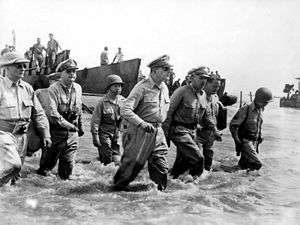
However, Leyte is most famous for its role in the reconquest of the Philippines in World War II. On 20 October 1944, General Douglas MacArthur waded ashore on Leyte, saying, "I have returned", but the Japanese did not give up so easily, as the ensuing Battle of Leyte proved. The convergence of naval forces resulted in the four-day Battle of Leyte Gulf, the largest naval battle in history.
Geography
The island measures about 180 kilometres (110 mi) north-south and about 65 kilometres (40 mi) at its widest point. In the north it nearly joins the island of Samar, separated by the San Juanico Strait, which becomes as narrow as 2 kilometres (1.2 mi) in some places. The island province of Biliran is also to the north of Leyte and is joined to Leyte island by a bridge across the narrow Biliran Strait. To the south, Leyte is separated from Mindanao by the Surigao Strait. To the east, Leyte is somewhat "set back" from the Philippine Sea of the Pacific Ocean, Samar to the northeast and the Dinagat Islands to the southeast forming the Leyte Gulf. To the west is the Camotes Sea.
Leyte is mostly heavily forested and mountainous, but the Leyte Valley in the northeast has much agriculture.
Demographics
| Population of Leyte Island | ||
|---|---|---|
| Year | Pop. | ±% p.a. |
| 1990 | 1,689,756 | — |
| 2000 | 1,952,496 | +1.46% |
| 2010 | 2,188,295 | +1.15% |
| 2015 | 2,388,518 | +1.68% |
| Source: National Statistics Office | ||
Historical and interesting sites
The Leyte Provincial capital is the seat of the provincial government where there is a historic mural depicting the First Mass of Limasawa in the Orient and the landing of General Douglas MacArthur.
The MacArthur Landing Memorial National Park in Red Beach, Palo, marks the 1944 landing by the American liberation forces. It also has a lagoon where a life-size statue of Gen. MacArthur stands. MacArthur's true landing took place at Dulag, Leyte.
Lake Danao is a violin-shaped lake hemmed by cloud-capped mountain ranges.
Kalanggaman Island in Palompon, Leyte is a virgin island with pure white sand. The ecological atmosphere of the island had been preserved by the municipality.
The Sto. Nino Shrine and Heritage Museum boasts the painting of the fourteen stations of the cross done by Filipino artists and a bas-relief of the legend of the first Filipino man and woman (Malakas and Maganda).
The San Juanico Bridge is the longest bridge in the Philippines.
Leyte Island is the birthplace of the Tinikling dance, popular throughout the Philippines.
On Friday, 8 November 2013, Super Typhoon Yolanda (Haiyan) destroyed 70-80% of the structures in its path on Leyte province. An estimated 10,000 people died and up to 620,000 people were displaced across the region.[3]
In popular culture
The 1959 Japanese film Nobi ("Fires on the Plain"), though filmed in Japan, is set in Leyte in 1945.
The film was remade in 2014 under the same name; this version was filmed in the Philippines.
References
- ↑ "Islands by Land Area". Island Directory Tables. United Nations Environment Programme. Retrieved 12 June 2013.
- ↑ Census of Population (2015): Highlights of the Philippine Population 2015 Census of Population (Report). PSA. Retrieved 20 June 2016.
- ↑ Mogato, Manuel; Ng, Roli (10 November 2013). "Philippines storm kills estimated 10,000, destruction hampers rescue efforts". Reuters. Retrieved 9 March 2016.
External links
 Media related to Leyte (island) at Wikimedia Commons
 Leyte Island travel guide from Wikivoyage
- Leyte Island - TA.com