Typhoon Haiyan
| Typhoon (JMA scale) | |
|---|---|
| Category 5 (Saffir–Simpson scale) | |
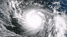
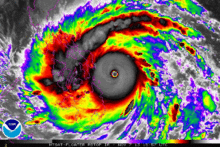
 Typhoon Haiyan at peak intensity on November 7 | |
| Formed | November 3, 2013 |
| Dissipated | November 11, 2013 |
| Highest winds |
10-minute sustained: 230 km/h (145 mph) 1-minute sustained: 315 km/h (195 mph) |
| Lowest pressure | 895 hPa (mbar); 26.43 inHg |
| Fatalities | 6,340 confirmed, 1,061 missing |
| Damage |
$3.86 billion (2013 USD) (Preliminary total) |
| Areas affected | |
| Part of the 2013 Pacific typhoon season | |
Typhoon Haiyan, known as Super Typhoon Yolanda in the Philippines, was one of the most intense tropical cyclones on record, which devastated portions of Southeast Asia, particularly the Philippines, on November 8, 2013.[1] It is the deadliest Philippine typhoon on record,[2] killing at least 10,000 people in that country alone.[3] Haiyan is also the strongest storm recorded at landfall. In January 2014, bodies were still being found.[4]
The thirtieth named storm of the 2013 Pacific typhoon season, Haiyan originated from an area of low pressure several hundred kilometers east-southeast of Pohnpei in the Federated States of Micronesia on November 2, 2013. Tracking generally westward, environmental conditions favored tropical cyclogenesis and the system developed into a tropical depression the following day. After becoming a tropical storm and attaining the name Haiyan at 0000 UTC on November 4, the system began a period of rapid intensification that brought it to typhoon intensity by 1800 UTC on November 5. By November 6, the Joint Typhoon Warning Center (JTWC) assessed the system as a Category 5-equivalent super typhoon on the Saffir-Simpson hurricane wind scale; the storm passed over the island of Kayangel in Palau shortly after attaining this strength.
Thereafter, it continued to intensify; at 1200 UTC on November 7, the Japan Meteorological Agency (JMA) upgraded the storm's maximum ten-minute sustained winds to 230 km/h (145 mph), the highest in relation to the cyclone. The Hong Kong Observatory put the storm's maximum ten-minute sustained winds at 285 km/h (180 mph)[5] prior to landfall in the central Philippines, while the China Meteorological Administration estimated the maximum two-minute sustained winds at the time to be around 78 m/s (280 km/h or 175 mph). At the same time, the JTWC estimated the system's one-minute sustained winds to 315 km/h (195 mph), unofficially making Haiyan the strongest tropical cyclone ever observed based on wind speed, a record which would then be surpassed by Hurricane Patricia in 2015 at 345 km/h (215 mph).[6] It's also the strongest tropical cyclone in the Eastern Hemisphere; several others have recorded lower central pressure readings. Several hours later, the eye of the cyclone made its first landfall in the Philippines at Guiuan, Eastern Samar. Gradually weakening, the storm made five additional landfalls in the country before emerging over the South China Sea. Turning northwestward, the typhoon eventually struck northern Vietnam as a severe tropical storm on November 10. Haiyan was last noted as a tropical depression by the JMA the following day.
The cyclone caused catastrophic destruction in the Visayas, particularly on Samar and Leyte. According to UN officials, about 11 million people have been affected – many have been left homeless.[7]
Meteorological history

On November 2, the Joint Typhoon Warning Center (JTWC) began monitoring a broad low-pressure area about 425 kilometers (265 miles) east-southeast of Pohnpei, one of the states in the Federated States of Micronesia.[nb 1] Moving through a region favoring tropical cyclogenesis,[9] the Japan Meteorological Agency (JMA) classified the developing system as a tropical depression early on November 3.[10][nb 2] Subsequent intensification resulted in the JMA upgrading the system to a tropical storm and assigning it the name Haiyan (Chinese: 海燕; literally: "petrel") at 0000 UTC on November 4.[10] Tracking generally westward along the southern periphery of a subtropical ridge,[12] rapid intensification ensued by November 5 as a central dense overcast with an embedded eye began developing; the JMA classified Haiyan as a typhoon later that day.[10] By November 6, the Philippine Atmospheric, Geophysical and Astronomical Services Administration (PAGASA) assigned the storm the local name Yolanda as it approached their area of responsibility.[13] Intensification slowed somewhat during the day, though the JTWC estimated the storm to have attained Category 5-equivalent super typhoon status on the Saffir–Simpson hurricane wind scale around 1200 UTC.[nb 3][15] Later, the eye of the typhoon passed over the island of Kayangel in Palau.[16]
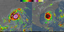
Around 1200 UTC on November 7, Haiyan attained ten-minute sustained winds of 230 km/h (145 mph) and a maximum intensity (lowest barometric pressure) of 895 mbar (hPa; 26.43 inHg).[10] Six hours later, the JTWC estimated Haiyan to have attained one-minute sustained winds of 315 km/h (195 mph) and gusts up to 378 km/h (235 mph), according to preliminary track data.[17]
The storm displayed some characteristics of an annular tropical cyclone, though a strong convective band remained present along the western side of the system.[17] At 2040 UTC on November 7, Typhoon Haiyan made landfall in Guiuan, Eastern Samar at peak intensity with ten-minute sustained winds of 230 km/h (145 mph) as measured by PAGASA.[18] The JTWC's unofficial estimate of one-minute sustained winds of 315 km/h (195 mph) would, by that measure, make Haiyan the most powerful storm ever recorded to strike land.[19] Interaction with land caused slight degradation of the storm's structure, though it remained an exceptionally powerful storm when it struck Tolosa, Leyte around 2300 UTC.[20] The typhoon made four additional landfalls as it traversed the Visayas:[21] Daanbantayan, Bantayan Island, Concepcion, and Busuanga Island. A weakened Haiyan, with its core disrupted by interaction with the Philippines, emerged over the South China Sea late on November 8.[22] Environmental conditions ahead of the storm soon became less favorable, as cool stable air began wrapping into the western side of the circulation.[23] Continuing across the South China Sea, Haiyan turned more northwesterly late on November 9 and through November 10 as it moved around the southwestern edge of the subtropical ridge previously steering it westward.[24] Rapid weakening ensued as Haiyan approached its final landfall in Vietnam,[25] ultimately striking the country near Haiphong around 2100 UTC as a severe tropical storm.[10] Once onshore, the storm quickly diminished and was last noted as it dissipated over Guangxi Province, China during November 11.[10]
Preparations
Micronesia and Palau
Upon JTWC's declaration of Tropical Depression 31W on November 3, a tropical storm warning was issued for Chuuk Lagoon, Losap, and Poluwat in the Federated States of Micronesia. Further west, Faraulep, Satawal, and Woleai, were placed under a typhoon watch while Fananu and Ulul were placed under a tropical storm watch.[26] The following day, the tropical storm warning expanded to include Satawal while a typhoon warning was issued for Woleai.[27] Much of Yap State and the islands of Koror and Kayangel in Palau were placed under a typhoon watch.[28] The government issued a mandatory evacuation for Kayangel, and although most residents ignored the warning, they all survived the storm.[16] As Haiyan progressed westward, the easternmost advisories were gradually discontinued.[28] As Haiyan intensified into a typhoon on November 5, warnings were raised across Palau and Yap State.[29][30] Government offices in Melekeok were used as an evacuation building for Palau.[31] Despite mandatory evacuation orders, most residents on Kayangel remained on the island and rode out the typhoon.[32]
Philippines
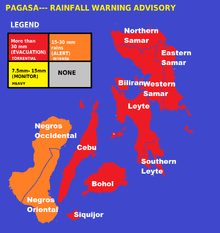
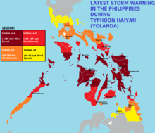
Shortly before Typhoon Haiyan entered the Philippine Area of Responsibility on November 6, PAGASA raised Public Storm Warning Signal (PSWS) No.1, the lowest of four levels, for much of the Visayas and Mindanao.[33] As the storm continued to approach the country, warnings expanded into Luzon and increased in severity for eastern areas.[34] By the evening of November 7, PSWS No. 4, the highest level of warning which indicates winds in excess of 185 km/h (115 mph) are expected, was raised for Biliran Island, Eastern Samar, Leyte, Northern Cebu, Metro Cebu, Samar, and Southern Leyte.[35][36] Through November 8, the coverage of PSWS No. 4 continued to expand, with areas in southern Luzon being included.[37]
Officials placed police officers in the Bicol Region ahead of the storm.[38] In the provinces of Samar and Leyte, classes were canceled, and residents in flood- and landslide-prone areas were required to evacuate.[39] Some of the storm-threatened areas were affected by an earlier earthquake in Bohol.[40] Then-Philippine President Noynoy Aquino requested the military to deploy planes and helicopters to the region expected to be affected.[41] As Haiyan was moving very fast, PAGASA issued warnings at different levels to about 60 of the 80 provinces, including the capital Metro Manila.[42] On November 8, the International Charter on Space and Major Disasters was activated, providing widespread charitable satellite coverage to relief organizations.[43]
Southern China
The State Flood Control and Drought Relief Headquarters hoisted a level three emergency response in the provinces of Hainan, Guangdong and Guangxi. All fishing vessels were urged to return to ports by noon on 9 November.[44] The Hong Kong Observatory issued the Strong Monsoon Signal at 19:10 HKT on 9 November,[45] and it was still in place on 13 November.[46]
Vietnam
On November 8, Prime Minister Nguyen Tan Dung activated the highest state of preparedness in the country.[47] Approximately 600,000 people across southern and central provinces were evacuated while a further 200,000 were evacuated in northern provinces. Alerts were sent to 85,328 seagoing vessels, with a collective crew of 385,372 people, to sail to safer waters away from the storm. Requests were sent to China, Malaysia, Indonesia, and the Philippines to aid any fishermen who needed immediate shelter from the typhoon.[48] Threatening Vietnam after two other typhoons, Wutip and Nari, there were concerns that the storm would cause significant damage to homes with makeshift repairs.[49] Roughly 460,000 military personnel and other authorities were mobilized to assist in evacuation efforts.[48] Hundreds of flights were canceled across the country while schools were closed on November 11. On the small island of Cồn Cỏ, all residents were moved to underground shelters with enough supplies for several days.[50] The International Federation of Red Cross and Red Crescent Societies (IFRC) branches in Vietnam prepared relief stockpiles, consisting of food, water, housing material, and ₫6.6 billion (US$310,000) in funds.[48] The local United Nations Resident Coordinator, Pratibha Mehta, praised the government's actions and credited them with saving numerous lives.[47] However, there were complaints by many residents that the warnings came too late.[50]
Impact
Micronesia and Palau
On Kayangel in Palau, a high storm surge damaged several houses,[31] while strong winds downed trees.[16] Despite residents' refusal to evacuate, no fatalities or major injuries took place on the island. Helicopters were flown to the island to survey damage and provide relief supplies. The government planned to evacuate those who were left homeless from the island.[32] Koror, Babeldaob and Kayangel each lost access to water and power.[16] In Koror, winds reaching as high as 120 km/h (75 mph) blew out rooftops and downed trees and power lines. A causeway linking an offshore hospital to the main island was temporarily shut down after being inundated by water.[51] On the northern end of Babeldaob, Haiyan damaged schools and buildings.[31] Lying closest to Haiyan at the time of the typhoon's passage, Kayangel was flooded in its entirety, and all homes were destroyed. Though no people were killed there, 69 others were displaced by the storm.[51]
Philippines
| |||||||||||||||||||||||||||||||||||||||||||||||||||||||||||||||||||||||||||||||||||||
|
SOURCE: Data gathered from the last update by National Disaster Risk Reduction and Management Council (NDRRMC) as of April 17, 2014.[52] | |||||||||||||||||||||||||||||||||||||||||||||||||||||||||||||||||||||||||||||||||||||
_making_landfall_on_Leyte_Island.gif)
| Costliest Philippine typhoons | ||||||||||||||||||||||||||||||||||||||||||||||||||||||||||||||||||||||||||||||||||||||||||||||||||||||||||||||||||||||||||||||||||||||||||||||||||||||||||||||||||||||||||||||||||||||||||||||||||||||||||||||||||||||||||||||||||||||||||||||||||||||||||||||||||||||||||||||||||||||||||||||||||||||||||||||||||||||||||||||||||||||||||||||||||||||||||||||||||||||||||||||||||||||||||||||||||||||||||||||||||||||||||||||||||||||||||||||||||||||||||||||||||||||||||||||||||||||||||||||||||||||||||||||||||||||||||||||||||||||||||||||
|---|---|---|---|---|---|---|---|---|---|---|---|---|---|---|---|---|---|---|---|---|---|---|---|---|---|---|---|---|---|---|---|---|---|---|---|---|---|---|---|---|---|---|---|---|---|---|---|---|---|---|---|---|---|---|---|---|---|---|---|---|---|---|---|---|---|---|---|---|---|---|---|---|---|---|---|---|---|---|---|---|---|---|---|---|---|---|---|---|---|---|---|---|---|---|---|---|---|---|---|---|---|---|---|---|---|---|---|---|---|---|---|---|---|---|---|---|---|---|---|---|---|---|---|---|---|---|---|---|---|---|---|---|---|---|---|---|---|---|---|---|---|---|---|---|---|---|---|---|---|---|---|---|---|---|---|---|---|---|---|---|---|---|---|---|---|---|---|---|---|---|---|---|---|---|---|---|---|---|---|---|---|---|---|---|---|---|---|---|---|---|---|---|---|---|---|---|---|---|---|---|---|---|---|---|---|---|---|---|---|---|---|---|---|---|---|---|---|---|---|---|---|---|---|---|---|---|---|---|---|---|---|---|---|---|---|---|---|---|---|---|---|---|---|---|---|---|---|---|---|---|---|---|---|---|---|---|---|---|---|---|---|---|---|---|---|---|---|---|---|---|---|---|---|---|---|---|---|---|---|---|---|---|---|---|---|---|---|---|---|---|---|---|---|---|---|---|---|---|---|---|---|---|---|---|---|---|---|---|---|---|---|---|---|---|---|---|---|---|---|---|---|---|---|---|---|---|---|---|---|---|---|---|---|---|---|---|---|---|---|---|---|---|---|---|---|---|---|---|---|---|---|---|---|---|---|---|---|---|---|---|---|---|---|---|---|---|---|---|---|---|---|---|---|---|---|---|---|---|---|---|---|---|---|---|---|---|---|---|---|---|---|---|---|---|---|---|---|---|---|---|---|---|---|---|---|---|---|---|---|---|---|---|---|---|---|---|---|---|---|---|---|---|---|---|---|---|---|---|---|---|---|---|---|---|---|---|---|---|---|---|---|---|---|---|---|---|---|---|---|---|---|---|---|---|---|---|---|---|---|---|---|---|---|---|---|---|---|---|---|---|---|---|---|---|---|---|---|---|---|---|---|---|---|---|---|---|---|---|---|---|---|---|---|---|---|---|---|---|---|---|---|---|---|---|---|---|---|---|---|---|---|---|---|---|---|---|---|---|---|---|---|---|---|---|---|---|
Typhoon Haiyan, called typhoon "Yolanda" in the Philippines, caused catastrophic damage throughout much of the islands of Leyte, where cities and towns were largely destroyed.[55] As of April 17, the National Disaster Risk Reduction and Management Council (NDRRMC) confirmed 6,300 fatalities across the country, 5,877 of those taking place in the Eastern Visayas.[3] The actual death toll remains unclear, being claimed to be at least 10,000 by the victims from Tacloban City, Leyte alone. As of November 13, Red Cross estimated that 22,000 people were missing while approximately 65,500 people were listed as such through Google Person Finder. Google, however, cautioned that this value is not to be read into, as shown during the 2011 Tōhoku earthquake and tsunami when more than 600,000 names were listed in contrast to the final death toll of roughly 20,000.[55] In Surigao City, 281.9 mm (11.10 in) of rainfall was recorded, much of which fell in under 12 hours.[56] Storm surges were also recorded in many places. In the island of Leyte and Samar, PAGASA measured 5–6 meter (15–19 ft) waves.[57] In Tacloban, Leyte, the terminal building of Tacloban Airport was destroyed by a 5.2 m (17 ft) storm surge up to the height of the second story.[58] Along the airport, a storm surge of 4 m (13 ft) was estimated.[59] Waves of 4.6 m (15 ft) were also estimated.[60] On the western coast of Samar, the storm surge was not as significant.[61] Guiuan in Eastern Samar was the point of Haiyan's first landfall, and was severely affected due to the typhoon's impacts.[62] Nearly all structures in the township suffered at least partial damage, many of which were completely flattened.[63] For several days following Haiyan's first landfall, the damage situation in the fishing town remained unclear due to lack of communication.[64] However, the damage could finally be assessed after Philippine Air Force staff arrived in Guiuan on November 10.[65] There was widespread devastation from the storm surge in Tacloban City especially in San Jose, with many buildings being destroyed, trees knocked over or broken, and cars piled up.[60] The low-lying areas on the eastern side of Tacloban city were hardest hit, with some areas completely washed away. Flooding also extended for 1 km (0.62 mi) inland on the east coast of the province.[60] City administrator Tecson John Lim stated that roughly 90 percent of the city had been destroyed.[55] Journalists on the ground have described the devastation as, "off the scale, and apocalyptic".[66] Most families in Samar and Leyte lost some family members or relatives; families came in from outlying provinces looking for relatives, especially children, who may have been washed away.[67] The entire first floor of the Tacloban City Convention Center, which was serving as an evacuation shelter, was submerged by storm surge. Many residents in the building were caught off-guard by the fast rising waters and subsequently drowned or were injured in the building.[68] Although wind speeds were extreme, the major cause of damage and loss of life appears to have been storm surge. The major focus of devastation appears to have been on the east coast of Samar and Leyte, with a particular focus on Tacloban, because of its location between Samar and Leyte, and the large population in low-lying areas.[61] Philippine Department of the Interior and Local Government (DILG) Secretary Mar Roxas said the scale of the relief operation that was now required was overwhelming, with some places described as a wasteland of mud and debris.[69] Sebastian Rhodes Stampa, head of a UN disaster assessment co-ordination team, said there was "destruction on a massive scale" in Tacloban. "There are cars thrown like tumbleweed and the streets are strewn with debris. The last time I saw something of this scale was in the aftermath of the [2004] Indian Ocean tsunami."[60] There is little communication in the city, and no mobile phone coverage. Up the east coast of the Leyte there are numerous towns and villages that are completely cut off without any assistance. Large parts of Leyte and Samar are without power and may have no power for a month.[66] The storm crossed the Visayas region for almost a day, causing widespread flooding. In Cebu and Bohol, struck by a magnitude 7.2 earthquake two weeks before, cities were also severely devastated.[70] During the morning of November 8, media stations across the country were able to broadcast live the destruction of Haiyan. However, before afternoon, all communications on the Visayas region failed. The Presidential Communications Department of President Benigno Aquino III had difficulty contacting DILG Secretary Mar Roxas and Defense Secretary Voltaire Gazmin in Tacloban City to plan relief.[71] Widespread power interruptions, landslides and flash floods were also reported. Major roads were blocked by trees, and impassable. 453 domestic and international airline flights were canceled. Some airports were also closed on November 8 and 9. Ferries were affected. Relief and rescue efforts were underway by November 9, but some places remained isolated and out of communication due to severe damage.[72] China and TaiwanTyphoon Haiyan reached Hainan Province, where severe damage took place and six people were killed in various incidents.[73] The hardest hit area was Qionghai, where roughly 3,500 people across 20 villages were isolated due to extensive flooding.[74] Direct economic losses in Hainan amounted to ¥4.9 billion (US$803 million).[73] In Guangxi Province to the north, heavy rains up to 380 mm (15 in) fell and wind gusts reached 100 km/h (60 mph).[75] An estimated 1.21 million people were affected, of whom 26,300 were evacuated. Two people died while four others went missing after a car fell off a flooded road into a river near Beihai.[76] Losses throughout Guangxi amounted to ¥275 million (US$45 million).[73][75] Approximately 900 homes and 25,500 hectares of crops were destroyed, while 8,500 homes were damaged. Additionally, an estimated 3 million people were affected by the storm throughout Southern China.[77] A cargo ship broke moorings at Sanya on November 8;[78] three members of the crew drowned while four others went missing.[75] One person also went missing off the coast of Lantau Island, Hong Kong.[79] Along the coast of New Taipei, 16 people were swept out to sea by three 8 m (26 ft) waves. After several hours of search and rescue, eight were hospitalized while the other eight drowned. This was considered the largest loss of life from waves in Taiwan in several years.[80] VietnamHaiyan made landfall as a severe tropical storm in Quảng Ninh Province on November 10 and produced high winds and widespread heavy rainfall which affected northern Vietnam.[81] Rainfall totals of up to 461 mm (18.1 in) and wind gusts of up to 147 km/h (91 mph) were recorded.[81] Ten people were killed while they were preparing for Haiyan's landfall, while no one was killed after the system made landfall; however, 4 people are missing in Quảng Ninh Province.[81] AftermathDue to extensive damage and high death toll, PAGASA announced that the name Yolanda would be stricken off the typhoon naming lists.[82][83] PAGASA chose the name Yasmin to replace Yolanda for the 2017 season. During their 2014 annual session the ESCAP/WMO Typhoon Committee announced that the name Haiyan would also be retired from its naming lists on January 1, 2015, and was therefore replaced by the name Bailu.[84] Philippines Animated satellite comparison of power outages across the Visayas following Typhoon Haiyan. 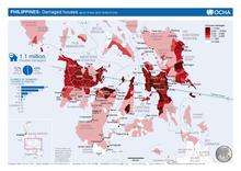 Map of damaged houses by municipality showing track of storm, from the United Nations, as of November 18, 2013 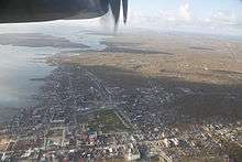 An aerial view of Guiuan, the town where the typhoon made its first landfall By November 11, the provinces of Aklan, Capiz, Cebu, Iloilo, Leyte, Palawan, and Samar, were placed under a state of national calamity, allowing the government to use state funds for relief and rehabilitation and to control prices of basic goods.[85] Additionally, approximately ₱30.6 million (US$700,000) had been allocated in relief assistance by the NDRRMC. Local and national agencies deployed a collective 18,177 personnel, 844 vehicles, 44 seagoing vessels, and 31 aircraft for various operations.[3] CBCP also declared 8 days of mourning for victims of the typhoon on the same date.[86] World Health Organization Representative in the Philippines Dr Julie Hall noted that while many survivors requiring medical attention in the first week suffer from trauma and fractures, the concern shifts toward chronic conditions as the weeks pass. The WHO coordinated the massive international response to help the Philippine government meet the acute need for healthcare services in the affected areas.[87] Extreme damage to infrastructure throughout the region posed logistical problems that greatly slowed relief efforts. Though aid was flown into local airports, most of it remained there as roads remained closed.[88] According to estimates on November 13, only 20 percent of the affected population in Tacloban City was receiving aid. With lack of access to clean water, some residents dug up water pipes and boiled water from there in order to survive. Thousands of people sought to evacuate the city via C-130 cargo planes, however, the slow process fueled further aggravation. Reports of escaped prisoners raping women in the city prompted a further urgency to evacuate. One resident was quoted as saying "Tacloban is a dead city."[55] Due to the lack of electricity, planes could only operate during the daylight, further slowing the evacuations. At dawn on November 12, thousands of people broke through fences and rushed planes only to be forced back by police and military personnel. A similar incident occurred later that day as a U.S. cargo plane was landing.[89] On November 14, a correspondent from the BBC reported Tacloban to be a "war zone," although the situation soon stabilized when the presence of government law enforcement was increased. Safety concerns prompted several relief agencies to back out of the operation, and some United Nations staff were pulled out for safety reasons. A message circulating among the agencies urged them to not go into Tacloban for this reason.[90] On the west coast of Leyte Island, residents in Ormoc were fearing that the focus on Tacloban City would leave them without aid. Though not as hard hit, roughly 90 percent of the city was damaged or destroyed and supplies were running low. Hospitals in the city were either shut down or working at partial capacity, leaving many of the nearly 2,000 injured in the city without medical assistance. In nearby Baybay, lack of assistance fueled anger and incited looting for survival.[91] In the coastal community Guiuan, which took the full brunt of the typhoon, Mayor Christopher Gonzalez is credited with saving countless lives after he incessantly urged residents to evacuate. He referred to the storm as "delubyo (deluge)," which roughly translates to Armageddon. Of the town's 45,000 residents, 87 died, 931 were injured, and 23 others were listed as missing. U.S. Navy Capt. Russell Hays, a medical officer, estimated that a storm of Haiyan's caliber could have killed as many as 4,500 in Guiuan alone had it not been for the mayor's efforts.[92] On November 18, the government of the Philippines launched an online portal, called the Foreign Aid Transparency Hub (FaiTH), that provides the public a transparency view of the funds and other aids received by the government from the international community.[93][94] To lead the management and rehabilitation efforts of the central provinces in the Philippines affected by Typhoon Haiyan, Philippines President Benigno Aquino III appointed Panfilo Lacson as Typhoon Haiyan Rehabilation Czar.[95] Environmental impact Devastated coconut trees in Guiuan Typhoon Haiyan knocked over Power Barge 103 of NAPOCOR in Estancia, Iloilo causing an oil spill.[96][97][98][99] As a result of the typhoon, the government is planning to replant mangroves in coastal areas while preserving the remaining ones.[100] Affected residents were allowed to return to their homes by the Department of Health on December 7, 2013 after an air quality test found out that benzene levels in affected areas reached near-zero parts per million. Earlier, residents were asked to evacuate affected areas as the benzene levels had reached unhealthy amounts.[101] Looting and violence The remains of a home destroyed by the storm in Tacloban City. Throughout Tacloban City, widespread looting took place in the days following Haiyan's passage. In some instances, relief trucks were attacked and had food stolen in the city. Two of the city's malls and numerous grocery stores were subjected to looting. A fuel depot in the city was guarded by armed police while 200 additional officers were dispatched to assist.[102] Security checkpoints have since been set up all over Tacloban and a curfew was imposed on residents to prevent more attacks.[103] Philippine military forces also prevented members of the New People's Army from ambushing a relief convoy bound for Samar in Matnog, Sorsogon, killing two.[104] President Benigno Aquino III considered declaring martial law in hopes of restoring order in affected areas.[105][106] Looting intensified as slow recovery efforts forced residents to seek any means necessary to survive. Tacloban city administrator Tecson John Lim stated, "The looting is not criminality. It is self-preservation." The Chicago Tribune reported that some areas were on the brink of anarchy, though Interior Secretary Mar Roxas denied such claims.[55] Further complicating efforts to retain order was the lack of officers reporting for work. In Tacloban, only 100 of the city's 1,300 police personnel reported for duty.[89] In Alangalang, just west of Tacloban, eight people were crushed to death after the walls of a warehouse collapsed during a raid on a government rice stockpile. Approximately 33,000 bags of rice, each weighing 50 kg (110 lb), were stolen. Warehouses were also raided in Jaro and Palo. Throughout the city of Tacloban itself, people began looting from homes as stores had been completely emptied.[55] Criticism of government response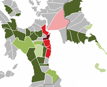 Color coded map of Eastern Visayas showing the number of deaths caused by Typhoon Haiyan. More than 1,000 500-999 100-499 50-99 25-49 1-24 0 Condemnations of slow government action in the relief effort in response to the typhoon mounted days after the storm had passed. Media reports criticized the Aquino administration for apparent lack of preparation and coordination among government agencies in the aid operation.[107][108] Up until November 12, five days after the typhoon struck, survivors continued to struggle with basic necessities such as food, water, and shelter while remote towns in Leyte and Samar were yet to be reached by aid.[109] The Philippine government responded by saying that they have dealt with the tragedy "quite well" but the response had been slow due to the breakdown of the local governance in affected areas where officials and employees, who were usually the first to respond in these events, were victims of the typhoon themselves.[110] Cabinet Secretary Jose Rene Almendras said that the national government had to take over despite logistical challenges and assured it is working toward providing aid the quickest way possible to the survivors.[111] The national Government was also criticized for putting the responsibility of handling the dead to the Bureau of Fire instead to the Department of Health. Dr. Racquel Fortun, one of the forensic experts to go to the area three days after the typhoon insisted that handling of the bodies is a health matter and therefore a responsibility of DOH.[112] Humanitarian crisis and population displacementThe Philippines faced a humanitarian crisis days after the typhoon hit much of the Visayas with 1.9 million homeless and more than 6,000,000 displaced.[113] In Tacloban alone, ninety percent of the structures are either destroyed or damaged while other cities, such as Ormoc, are reporting similar damage.[114] The United Nations fear that the possibility of the spread of disease is high due to the lack of food, water, shelter, and medication. Casualties have been reported as a result of the lack of aid in affected areas and the number of dead is likely to rise.[115] As a result of the damage in Tacloban and much of Leyte, thousands of people who once lived in the area left and made their way into less affected areas such as Cebu and Manila.[116] Catbalogan reported that their population more than doubled after the typhoon with the influx of refugees into the city.[117] Around 20,000 people have fled to Manila as a result of the storm.[118] International responseMain article: Humanitarian response to Typhoon Haiyan
Supranational bodies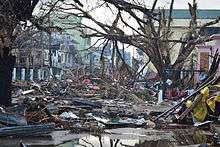 Debris littering the streets of Tacloban City on November 14, nearly a week after the storm struck. The United Nations said it was going to increase critical relief operations as a result of the devastation caused by the typhoon. Its Manila office issued a statement that read, "Access remains a key challenge as some areas are still cut off from relief operations. Unknown numbers of survivors do not have basic necessities such as food, water and medicines and remain inaccessible for relief operations, as roads, airports and bridges were destroyed or covered in wreckage."[209] The United Nations also began relief operations by this time; however, the severe damage to infrastructure hampered efforts to distribute supplies.[102] The UN activated the Cluster System, in which groups of humanitarian organizations (UN and non-UN) work to restore health, shelter, nutrition and economic activity.[210] The World Health Organization, which leads the Health Cluster, the largest one, has developed guidance on donations of medicine and healthcare equipment, so that the Philippines receives supplies appropriate for this emergency. According to WHO, many people suffered cuts, wounds, and broken bones during the disaster and others were injured in flooding that followed the typhoon.[211] Interpol announced that they would send in Interpol officers from Lyon to help local law enforcement identify any of the corpses that are unidentified.[212] The World Health Organization has spearheaded initiatives among help workers, especially from the Department of Health (Philippines), in extending Psychological First Aid to people in typhoon-affected areas. WHO Representative in the country Dr Julie Hall foresees long-lasting effects from the typhoon. She calls for increased preparedness to give support to families and communities for the long-term, citing the need for more trained field workers.[213] Celebrities, companies, and NGOsAmerican band Journey donated $350,000 to help relief efforts in the Philippines, and its lead singer had a message for his homeland: "Don't Stop Believin'". Arnel Pineda (the band's Filipino vocalist) and the rest of the band announced the donation on November 15, 2013. It will go to the United Nations World Food Programme, which is providing Filipinos with food assistance. The donation should provide 1.4 million meals.[214] IKEA, Walmart, Samsung, and HSBC are among those taking advantage of the event to donate to those in need.[215][216] Northwestern Mutual announced they will donate $100,000 to the American Red Cross.[217] The Coca-Cola Company says they have donated $2.5 million of their advertising budget to the relief efforts as of November 25.[218] By mid-December FIFA donated $1 million.[219] DHL deployed its Asia Pacific Disaster Response Team to the disaster areas to provide on-the-ground logistics support to assist with the relief effort in the aftermath of the devastating Typhoon Haiyan. Three rotating teams made up of volunteer employees from the Asia Pacific region were based at the Mactan Cebu Airport on Cebu island, providing support and assistance to the country's most affected areas west of Leyte Island, including Guiuan, Roxas, and Tacloban city.[220] Many smaller initiatives were founded as well - e.g. to prepare by donating to children a typhoon-ready backpack as floating device.[221] 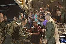 U.S. Marines assisting in the Philippine disaster relief. Sixteen-time NBA Champions Los Angeles Lakers donated $150,000 [222] to the Philippine Red Cross to aid the typhoon affected victims. During their home game against the Memphis Grizzlies, Kobe Bryant handed the check to the Junior NBA players representing the Philippines. His team mate, Pau Gasol, pledged to donate $1,000 per point to UNICEF[223] with the directive to help victims of Super Typhoon Haiyan in the country as well. He scored 24 points in a won game against the Golden State Warriors. Major League Baseball donated $200,000 to UNICEF and the American Red Cross, with Commissioner Bud Selig encouraging fans to donate to the organizations.[224] UNICEF delivered portable toilets and hygiene supplies to the region and also appealed for $34 million to help the four million children affected.[225] The American Red Cross announced that they collected $11 million in donations for the Philippines Relief Fund.[226] Mercy Corps dispatched a "emergency response" team to help with humanitarian efforts.[227] MAP International launched medical relief efforts providing over $10 million in medicines and supplies to the Philippines. Among the NGO responses, among the most comprehensive disaster response came from the Taiwan-based "Buddhist Tzu Chi Foundation"., which organized a large-scale cash-for-work program in Tacloban from Nov 20 to Dec 8 with up to 31,000 participants per day, totaling nearly 300,000 day shifts. This operation not only helped clean out the thousands of tons of debris covering the city, but also kick-started the local economy. Tzu Chi also contributed emergency cash aid of 8000, 12000 or 15000 pesos depending on family size for over 60,000 families in the affected areas of Tacloban, Ormoc, Palo, Tanauan and Tunga, and has been providing free clinics, hot meals, and temporary class rooms for over 15 schools in the area. Doctors Without Borders is sending 200 tons of aid.[207][228] The International Society for Krishna Consciousness's Food For Life Global, the world's largest vegan food relief organisation, raised money and provided vegan meals in the Philippines to Typhoon Haiyan survivors.[229][230] Other NGOs run by faith-based organisations that raised money and/or aided in the disaster relief efforts of Typhoon Haiyan included Catholic Relief Services,[231] Catholic Medical Mission Board (CMMB),[231] Adventist Development and Relief Agency (ADRA),[231] LDS Philanthropies,[232] American Jewish Joint Distribution Committee (AJJDC),[231] Samaritan's Purse,[231] Salvation Army,[231] Christian Children's Fund of Canada,[231] MAP International and World Vision.[231] The Iglesia Ni Cristo (INC), the largest indigenous Christian church based in the Philippines held series of massive relief distributions and medical and dental missions to affected population of the storm to different parts of Visayas.[233] The humanitarian mission was done under the "Lingap sa Mamamayan" (Aid for Humanity) project in cooperation with the Felix Y. Manalo (FYM) Foundation Inc., the INC’s charitable arm.[234][235] The church conducted the largest walk for a cause in the world (walkathon) on February 15, 2014, dubbed as 'Iglesia Ni Cristo World Wide Walk for Those Affected by Typhoon Yolanda/Haiyan'.[236][237] The walk for a cause raised millions of money to help the victims of the super typhoon for the construction of their houses and shelters. The aim of the activity is to make the world understand that Haiyan survivors are still in dare need of help and financial assistance. Indeed, the worldwide walk caught the attention of the world when it breaks two Guinness world records as the largest charity walk in a single venue (Manila, Philippines) with 175,000 participants, and largest charity walk in 24 hours for multiple venues (from Christchurch, New Zealand to Hawaii, USA) in 13 time zones, 54 countries, 24 hours with 519, 521 participants.[238][239] Celebrities such as David and Victoria Beckham,[240] Stephen Colbert,[241] Kim Kardashian,[242] David Guetta,[243] and The X Factor contributed to the fundraisng.[244] On November 26, iTunes released a compilation album entitled Songs for the Philippines featuring different artists, including Katy Perry, Madonna, Bob Dylan, and The Beatles.[245] All proceeds will go to the Philippine Red Cross.[245] One Republic donated $100,000 on November 30, 2013.[246] Other celebrities that offered their support included Linkin Park, The Offspring,[247] Alicia Keys,[248] and Justin Bieber.[249] On the day of his death, actor Paul Walker attended a charity event for his organization, Reach Out Worldwide, for the victims of the typhoon that was held right before his accident.[250] On March 11, 2014, a benefit concert called The Pinoy Relief Benefit Concert was held at Madison Square Garden in New York, City. Jennifer Hudson, Pentatonix, A Great Big World, Plain White T's, Jessica Sanchez, Charice and REO Brothers performed. Special guests also included Dr. Oz, Dante Basco, Bobby Lopez, Kristen Anderson-Lopez and Apl.de.ap. 100% of proceeds raised directly went to the Typhoon Haiyan survivors.[251] Pinoy Relief was created to help survivors and focus on three specific areas: restoring livelihoods, building classrooms and providing shelter in partnership with local NGOs, Habitat for Humanity Philippines and Operation Blessing Philippines.[252] On March 13, 2016, former United States of America vice president Al Gore, visited Tacloban and delivered his speech in front of the survivors of Haiyan. He also dropped by at the MV Eva Jocelyn, a cargo ship that washed out inland during the typhoon and now converted into a memorial park.[253] Politics involving aid relief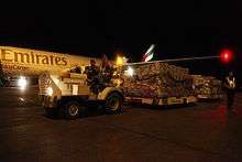 First UK-funded humanitarian flight arrives at Mactan-Cebu International Airport. 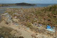 The island of Binuluanguan overflown by a helicopter from HMS Daring. The aid contributions of China and the United States were given focus with regards to their involvement in the politics of the Philippines.[254] Apart from having the two largest economies in the world, both countries are involved in a complex relationship with the island country. China is currently disputing the Spratly Islands in the South China Sea with the Philippines while the United States used to be an occupying power and currently has a mutual defense treaty with the islands.[255] China was initially criticized for its meager contribution of US $100,000 cash each from the government and the Chinese Red Cross to the typhoon victims, which led to commentary about its disputes with the Philippines.[256] Earlier in 2013, the Philippines sued China over the nine-dotted line. Commentators attribute this low amount to China's intentions to isolate the Philippines while strengthening its ties with the rest of Southeast Asia.[257] The move had mixed reactions from the public of China with some commending its decision while others, such as The Global Times, insisted that China should be a responsible power. China later increased its contributions by US$1.64 million in supplies [133][258] and sent its naval hospital ship Peace Ark for disaster relief."[134] The contributions of the United States was in contrast to that of China. It gave the Philippines an amount of US$51.9 million worth of aid apart and deployed the United States Marines, United States Navy and United States Air Force in order to assist with the humanitarian operations.[259] This was seen by observers as part of the Asia pivot that the United States government had previously announced. The Philippine government had been discussing with the U.S. plans regarding the deployment of U.S. military troops within the country. Aid contributions of the U.S. was seen as a sign of goodwill in order to further strengthen relations.[260] VietnamFollowing Typhoon Haiyan's landfall in Vietnam, widespread search and rescue missions took place in the affected provinces. Damage assessments were also conducted in 13 provinces to determine what aid was needed. The IFRC began distribution of relief supplies and assisted residents in returning home by November 12. Operations regarding the aftermath of Typhoon Wutip were temporarily suspended due to Haiyan.[48] Climate changePolitical leaders and climate scientists connected the typhoon to climate change, both at the time and subsequently.[261] The 2013 United Nations Climate Change Conference was coincidentally in progress when the typhoon struck and Yeb Saño, the lead negotiator of the Philippines delegation, received a standing ovation at the conference when he declared a hunger strike. In solidarity with my countrymen who are struggling to find food back home, I will now commence a voluntary fasting for the climate; this means I will voluntarily refrain from eating food during this COP, until a meaningful outcome is in sight. Several delegates, including American delegate Collin Reese, joined him in fasting. Sixty people from Climate Action Network, an umbrella group of environmental non-governmental organisations, also joined the hunger strike.[263] The correlation between the increasing intensity of storms and the progression of climate change was discussed by climate scientists. "Typhoons, hurricanes and all tropical storms draw their vast energy from the warmth of the sea. We know sea-surface temperatures are warming pretty much around the planet, so that's a pretty direct influence of climate change on the nature of the storm," said Will Steffen, director of the Australian National University climate change institute.[264] Myles Allen, head of the climate dynamics group at the University of Oxford, said that "The current consensus is that climate change is not making the risk of hurricanes any greater, but there are physical arguments and evidence that there is a risk of more intense hurricanes."[264] The Huffington Post made the point that the 70% deforestation of the Philippines since 1900, as reported by the national Forest Management Bureau, made far more lethal flooding from cyclones like Haiyan more likely.[265] The IPCC Fifth Assessment Report had stated in September of the same year that "Time series of cyclone indices such as power dissipation, an aggregate compound of tropical cyclone frequency, duration, and intensity that measures total wind energy by tropical cyclones, show upward trends in the North Atlantic and weaker upward trends in the western North Pacific since the late 1970s."[264] In popular mediaA detailed analysis of Typhoon Haiyan and its destruction in the Philippines was featured in a documentary called Megastorm: World's Biggest Typhoon. It aired on December 30, 2013 on Discovery Channel.[266] See also
Notes
References
External links
| ||||||||||||||||||||||||||||||||||||||||||||||||||||||||||||||||||||||||||||||||||||||||||||||||||||||||||||||||||||||||||||||||||||||||||||||||||||||||||||||||||||||||||||||||||||||||||||||||||||||||||||||||||||||||||||||||||||||||||||||||||||||||||||||||||||||||||||||||||||||||||||||||||||||||||||||||||||||||||||||||||||||||||||||||||||||||||||||||||||||||||||||||||||||||||||||||||||||||||||||||||||||||||||||||||||||||||||||||||||||||||||||||||||||||||||||||||||||||||||||||||||||||||||||||||||||||||||||||||||||||||||||
