Liawenee
| Liawenee Tasmania | |||||||
|---|---|---|---|---|---|---|---|
 Liawenee | |||||||
| Coordinates | 41°53′58.92″S 146°40′9.84″E / 41.8997000°S 146.6694000°ECoordinates: 41°53′58.92″S 146°40′9.84″E / 41.8997000°S 146.6694000°E | ||||||
| Population |
303 [1] | ||||||
| Established | 11 June 1920 | ||||||
| Postcode(s) | 7030 | ||||||
| Elevation | 1,065 m (3,494 ft) | ||||||
| Location | 122 km (76 mi) NNW [2] of Hobart | ||||||
| |||||||
Liawenee (/laɪɑ:wi:ni:/) is a small town in Tasmania, Australia built near Great Lake and the River Ouse, and was established on 11 June 1920. The town is known for its fishing at nearby Great Lake and hosts several fishing events.[3]
Liawenee and surrounding Miena Dam experience annual mean maximum temperatures of 12.6 [4] and 10.1 [5] respectively and are thus amongst the coldest permanently inhabited places in Australia; irrespective of Miena Dam Liawenee is colder on this metric than notable mainland sites of a similar altitude such as Nimmitabel (15.6)[6] and Cooma (19.4)[7] as well as Thredbo village (13.5)[8] - a station of considerably greater altitude (1380m AMSL). Within Tasmania, only the uninhabited summits of Mount Wellington (Kunanyi) and Mount Read record lower annual mean maximum temperatures (7.8[9] and 8.7[10] respectively) although other mountains of Tasmania that currently lack weather stations may experience similar or colder conditions also.
Origins
Liawenee's name was derived from a Tasmanian Aboriginal word meaning 'frigid'.
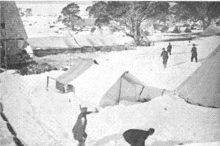
It was founded in June 1920 as a camp for the workers at the nearby hydro-electric undertaking as well as some other towns such as Miena. In its humble beginnings the population consisted entirely of the workers at the hydro-electric plant and their families; the houses were wood and canvas.[11]
In this time the camp boasted three cottages where married couples lived, and a so-called hospital that was only twice the size of a house making it more of a first aid clinic. The original layout included blacksmiths, bakeries and a chaff store which made up the requirements for a workforce making it a work camp rather than a village. During the Second World War the town became much larger, but settlers consisted mainly of men who were paid for their work yet could find no place to spend the money, nor a place to deliver mail.[12]
The first Liawenee Post Office opened on 1 October 1919 and closed in 1922. The second opened on 2 February 1948 but closed in 1953.[13] At present Liawenee consists of a police station and several buildings.
Geography
Liawenee is located along the Lake highway among the central Tasmanian mountains. The mountains surrounding Liawenee include Split rock, Willow Run Hill, Headlam Hill, McDowall Hill with the latter being the tallest. It is known as the twelfth highest locality in Tasmania and the nearest beach is 100 kilometres (62 mi) west south west from Liawenee’s centre. The rough terrain suits bush-walking and mountain biking, except during winter, and the nearest populated area is Miena, about 13 km south. The section of the highway to Miena will be sealed during 2015.
Climate
Owing to its high altitude location in the far south of Australia, Liawenee is one of the few places in the continent with a subpolar oceanic climate (Köppen Cfc). February temperatures still range between 4 °C (39 °F) to 17 °C (63 °F) which is colder than most mainland Australian winters south of about Geraldton in Western Australia.[14] Even though their summers are cool-mild they still have the occasional day where a northerly wind blows causing temperatures to climb into the mid to high twenties but rarely into the thirties. The coldest day on record was set on 9 July 1997 where the temperature did not rise above −2.0 °C (28.4 °F). A record low of −12.1 °C (10.2 °F) was recorded at Liawenee on the morning of 9 July 2013. As a result, Liaweene is among the coldest places in Australia in terms of maximum temperature.
Days below 10 °C (50 °F) have been recorded in summer with the coldest day in summer being a mere 6 °C (43 °F) recorded on 8 January 1994.[15] The town spends an annual average of only 0.7 days above 30 °C (86 °F) and 0.1 of that over 35 °C (95 °F) but in contrast it spends a massive 210.2 days below 2 °C (36 °F) and 142.4 of that below freezing. It spends about 136 cloudy days a year which peaks in July at 15 days and drops to an average of 8 days in February, but it still has about 206 days of measurable precipitation each year. The humidity is high but the lack of warm weather means that it rarely becomes uncomfortable. The annual mean 9am humidity is 82% and the annual mean 3pm humidity is 67%.
| Climate data for Liawenee | |||||||||||||
|---|---|---|---|---|---|---|---|---|---|---|---|---|---|
| Month | Jan | Feb | Mar | Apr | May | Jun | Jul | Aug | Sep | Oct | Nov | Dec | Year |
| Record high °C (°F) | 35.0 (95) |
31.6 (88.9) |
29.5 (85.1) |
24.0 (75.2) |
19.8 (67.6) |
14.5 (58.1) |
12.1 (53.8) |
16.8 (62.2) |
19.2 (66.6) |
25.4 (77.7) |
29.5 (85.1) |
32.0 (89.6) |
35.0 (95) |
| Average high °C (°F) | 18.6 (65.5) |
18.7 (65.7) |
16.2 (61.2) |
12.7 (54.9) |
9.2 (48.6) |
6.2 (43.2) |
5.5 (41.9) |
6.4 (43.5) |
9.1 (48.4) |
11.9 (53.4) |
14.7 (58.5) |
17.0 (62.6) |
12.2 (54) |
| Average low °C (°F) | 5.5 (41.9) |
5.5 (41.9) |
3.7 (38.7) |
2.0 (35.6) |
0.3 (32.5) |
−1.1 (30) |
−1.5 (29.3) |
−1.8 (28.8) |
−0.5 (31.1) |
0.7 (33.3) |
2.1 (35.8) |
3.9 (39) |
1.6 (34.9) |
| Record low °C (°F) | −4.0 (24.8) |
−3.5 (25.7) |
−5.0 (23) |
−6.5 (20.3) |
−8.9 (16) |
−10.4 (13.3) |
−12.1 (10.2) |
−11.1 (12) |
−7.7 (18.1) |
−6.4 (20.5) |
−5.6 (21.9) |
−4.3 (24.3) |
−10.4 (13.3) |
| Average precipitation mm (inches) | 67.6 (2.661) |
48.7 (1.917) |
53.9 (2.122) |
78.9 (3.106) |
89.7 (3.531) |
99.7 (3.925) |
128.6 (5.063) |
122.1 (4.807) |
111.9 (4.406) |
91.8 (3.614) |
75.0 (2.953) |
75.8 (2.984) |
1,042.1 (41.028) |
| Average rainy days | 12.9 | 10.2 | 13.4 | 17.1 | 18.8 | 20.3 | 23.0 | 22.5 | 19.9 | 18.4 | 15.8 | 14.3 | 206.6 |
| Mean monthly sunshine hours | 269.7 | 243.0 | 235.6 | 177.0 | 145.7 | 108.0 | 108.5 | 161.2 | 180.0 | 238.7 | 255.0 | 275.9 | 2,398.3 |
| Source: Bureau of Meteorology[15] | |||||||||||||
References
- ↑ "2011 Census QuickStats: Miena". Australian Bureau of Statistics. Retrieved 2016-01-27.
- ↑ "Information about Liawenee(7030) in Tasmania". Myboot.com.au. Retrieved 2010-05-08.
- ↑ "Liawenee Open Weekend — Fishing Tasmania". Fishingtasmania.net. 1999-02-22. Retrieved 2010-05-08.
- ↑ "Climate statistics for Australian locations: Summary Statistics Liawenee". Australian Bureau of Meteorology. Retrieved 2016-01-27.
- ↑ "Climate statistics for Australian locations: Summary Statistics Miena Dam". Australian Bureau of Meteorology. Retrieved 2016-01-27.
- ↑ "Climate statistics for Australian locations: Summary Statistics Nimmitabel". Australian Bureau of Meteorology. Retrieved 2016-01-27.
- ↑ "Climate statistics for Australian locations: Summary Statistics Cooma". Australian Bureau of Meteorology. Retrieved 2016-01-27.
- ↑ "Climate statistics for Australian locations: Summary Statistics Thredbo Village". Australian Bureau of Meteorology. Retrieved 2016-01-27.
- ↑ "Monthly mean maximum temperature, Kunanyi (Mount Wellington Pinnacle)". Australian Bureau of Meteorology. Retrieved 2016-01-27.
- ↑ "Monthly mean maximum temperature, Mount Read". Australian Bureau of Meteorology. Retrieved 2016-01-27.
- ↑ /11477213?searchTerm=Liawenee+settlement
- ↑ The developing Tasmanian mountain towns
- ↑ Premier Postal History. "Post Office List". Premier Postal Auctions. Retrieved 16 June 2012.
- ↑ Once you are in this site Ctrl F liawenee to locate my source
- 1 2 "Climate statistics for Liawenee". Bureau of Meteorology. Retrieved 22 April 2016.