| NM# |
Monument name |
Description |
Image |
Townland |
Location
|
|---|
| 645 | Altar (tomb) | Wedge Tomb | | Altar |
51°30′49″N 9°38′38″W / 51.51373°N 9.64398°W / 51.51373; -9.64398 |
| 314 | Ardskeagh | Church | | Ardskeagh |
52°12′32″N 8°44′30″W / 52.20897°N 8.74164°W / 52.20897; -8.74164 |
| 301 | Ballybeg | Dovecote |  | Ballybeg East |
52°13′13″N 8°40′11″W / 52.22023°N 8.66984°W / 52.22023; -8.66984 |
| 301 | Ballybeg | Tower | 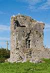 | Ballybeg West |
52°13′12″N 8°40′07″W / 52.21989°N 8.66851°W / 52.21989; -8.66851 |
| 301 | Ballybeg Abbey | Friary (Augustinian) |  | Buttevant |
52°13′10″N 8°40′11″W / 52.21941°N 8.66976°W / 52.21941; -8.66976 |
| 22 | Templekieran, Clear Island | Church & Cross inscribed pillar | | Ballyieragh North |
51°26′00″N 9°30′00″W / 51.43333°N 9.5°W / 51.43333; -9.5 |
| 425 | Ballinacarriga Castle | Castle | 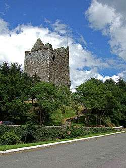 | Dunmanway |
51°42′20″N 9°01′54″W / 51.70561°N 9.03175°W / 51.70561; -9.03175 |
| 641 | Barryscourt Castle | Castle |  | Carrigtwohill |
51°54′17″N 8°15′34″W / 51.90462°N 8.25937°W / 51.90462; -8.25937 |
| 594 | Blossomfort | Ringfort | | Blossomfort |
52°10′07″N 8°44′24″W / 52.16869°N 8.73988°W / 52.16869; -8.73988 |
| 558 | Glanworth | Medieval tower |  | Boherash |
52°11′21″N 8°21′20″W / 52.189069°N 8.355511°W / 52.189069; -8.355511 |
| 558 | Glanworth Castle | Castle | 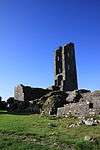 | Glanworth |
52°11′17″N 8°21′17″W / 52.18817°N 8.3547°W / 52.18817; -8.3547 |
| 558 | Rock Abbey, Glanworth | Friary (Franciscan) | 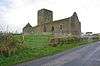 | Boherash |
52°11′21″N 8°21′22″W / 52.18911°N 8.35625°W / 52.18911; -8.35625 |
| 450 | Breeny More | Stone Circle & boulder burials | | Breeny More |
51°44′28″N 9°22′32″W / 51.7412°N 9.3755°W / 51.7412; -9.3755 |
| 202 | Buttevant Abbey | Friary (Franciscan) | 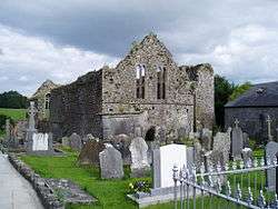 | Buttevant |
52°13′52″N 8°40′09″W / 52.23124°N 8.66909°W / 52.23124; -8.66909 |
| 233 | Cahervagliar | Ringfort | | Cappeen West |
51°47′35″N 8°59′49″W / 51.79310°N 8.99694°W / 51.79310; -8.99694 |
| 660 | Carrigagulla | Stone Circle |  | Ballinagree |
52°00′01″N 8°54′59″W / 52.000410°N 8.916359°W / 52.000410; -8.916359 |
| 255 | Carrigaphooca Castle | Castle | 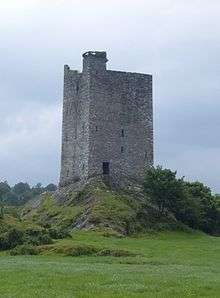 | Macroom |
51°54′19″N 8°57′45″W / 51.90531°N 8.96248°W / 51.90531; -8.96248 |
| 255 | Carrigaphooca stone circle | Stone Circle | | Carrigaphooca |
51°54′35″N 9°01′30″W / 51.909610°N 9.024975°W / 51.909610; -9.024975 |
| 656 | Castledonovan Castle | Castle | 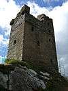 | Castledonovan |
51°41′32″N 9°16′57″W / 51.69211°N 9.28259°W / 51.69211; -9.28259 |
| 281 | Mallow Castle | Castle | 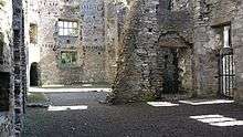 | Castlelands |
52°08′05″N 8°38′18″W / 52.13459°N 8.63824°W / 52.13459; -8.63824 |
| 536 | Clodagh | Standing Stones - Pair | | Clodagh, County Cork |
51°41′53″N 9°13′27″W / 51.69804°N 9.22428°W / 51.69804; -9.22428 |
| 240 | Conna Castle | Castle |  | Conna |
52°05′40″N 8°06′06″W / 52.09454°N 8.10170°W / 52.09454; -8.10170 |
| 592 | Carn Tierna | Hillfort & Cairn | | Coolcarron, Corrin |
52°06′54″N 8°16′58″W / 52.114982°N 8.282754°W / 52.114982; -8.282754 |
| 565 | Coolcoulaghta | Standing Stones - Pair | | Coolcoulaghta |
51°35′48″N 9°32′36″W / 51.59669°N 9.54334°W / 51.59669; -9.54334 |
| 395 | Coole Upper | Two Churches | 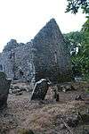 | Coole Upper |
52°06′31″N 8°12′12″W / 52.10873°N 8.20338°W / 52.10873; -8.20338 |
| 600 | Derryarkane | Stone Circle & Standing Stone | | Derryarkane |
51°43′43″N 9°22′19″W / 51.72859°N 9.37206°W / 51.72859; -9.37206 |
| 296 | Drishane Castle | Castle |  | Drishane More |
52°04′31″N 9°02′55″W / 52.07515°N 9.04849°W / 52.07515; -9.04849 |
| 339 | Dromaneen Castle | Castle |  | Dromaneen |
52°07′35″N 8°43′50″W / 52.12636°N 8.73066°W / 52.12636; -8.73066 |
| 381 | Drombeg Stone | Circle, Hut Site & Fulacht Fiadh | 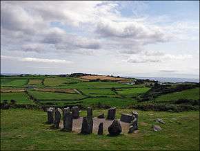 | Glandore |
51°33′52″N 9°05′13″W / 51.56455°N 9.08702°W / 51.56455; -9.08702 |
| 169 | Sherkin Abbey | Friary (Franciscan) |  | Sherkin Island |
51°28′28″N 9°23′58″W / 51.474487°N 9.399394°W / 51.474487; -9.399394 |
| 374 | Farranahineeny | Stone Row | | Farranahineeny |
51°47′42″N 9°08′20″W / 51.79494°N 9.13888°W / 51.79494; -9.13888 |
| 284 | Knockdrum Stone Fort | Cashel | 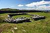 | Farrandau |
51°31′36″N 9°11′39″W / 51.52669°N 9.19413°W / 51.52669; -9.19413 |
| 426 | Ballycrovane | Ogham Stone | 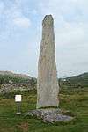 | Faunkill and the Woods |
51°42′47″N 9°56′41″W / 51.71315°N 9.94460°W / 51.71315; -9.94460 |
| 535 | Charles Fort | Star-Shaped-Fort | 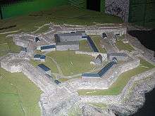 | Summer Cove |
51°41′47″N 8°29′56″W / 51.6965°N 8.499°W / 51.6965; -8.499 |
| 552 | Greenhill | Ogham Stones | | Greenhill |
52°04′42″N 8°36′28″W / 52.07826°N 8.60785°W / 52.07826; -8.60785 |
| 502 | Island | Wedge Tomb | | Island |
52°04′03″N 8°34′43″W / 52.06762°N 8.57854°W / 52.06762; -8.57854 |
| 490 | Kilbolane Castle | Castle | 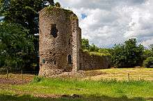 | Milford |
52°20′20″N 8°51′04″W / 52.339°N 8.851°W / 52.339; -8.851 |
| 182 | Kilcrea Abbey | Friary (Franciscan) |  | Ovens |
51°51′54″N 8°42′41″W / 51.86498°N 8.71128°W / 51.86498; -8.71128 |
| 316 | Kileenemer | Church |  | Killeenemer |
52°12′56″N 8°19′43″W / 52.21546°N 8.32850°W / 52.21546; -8.32850 |
| 436 | Kilnaruane/Bantry Pillar Stone | Shaft of High Cross | 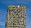 | Kilnaruane |
51°40′17″N 9°28′05″W / 51.67132°N 9.46799°W / 51.67132; -9.46799 |
| 420 | Knocknakilla | Stone Circle | 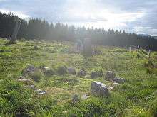 | Macroom and Millstreet |
52°00′22″N 9°01′25″W / 52.00618°N 9.02355°W / 52.00618; -9.02355 |
| 318 | Labbacallee wedge tomb | Wedge Tomb |  | Glanworth |
52°10′11″N 8°20′13″W / 52.16984°N 8.33689°W / 52.16984; -8.33689 |
| 18 | Labbamolaga | Church & Grave slabs | 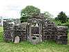 | Labbamolaga |
52°18′39″N 8°20′51″W / 52.31080°N 8.34761°W / 52.31080; -8.34761 |
| 333 | Liscarroll Castle | Castle |  | Liscarroll |
52°15′40″N 8°48′12″W / 52.26108°N 8.80338°W / 52.26108; -8.80338 |
| 571 | Lissacresig | Stone Circle | | Lissacresig |
51°55′33″N 9°03′49″W / 51.92590°N 9.06369°W / 51.92590; -9.06369 |
| 571 | Lissacresig | Ringfort | | Lissacresig |
51°55′43″N 9°03′59″W / 51.92863°N 9.06642°W / 51.92863; -9.06642 |
| | Maughanasilly | Stone Row | | Maughanasilly |
51°46′14″N 9°23′11″W / 51.7706°N 9.3865°W / 51.7706; -9.3865 |
| 411 | Castlelyons Friary | Friary (Carmelite)[1] |  | Mohera |
52°05′21″N 8°14′01″W / 52.08918°N 8.23366°W / 52.08918; -8.23366 |
| 525 | James Fort | Star-Shaped-Fort & Blockhouse | 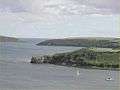 | Castlepark |
51°41′59″N 8°30′37″W / 51.69964°N 8.51028°W / 51.69964; -8.51028 |
| 517 | Kanturk Castle | Castle | 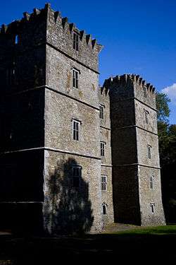 | Kanturk |
52°09′55″N 8°54′10″W / 52.16530°N 8.90279°W / 52.16530; -8.90279 |
| 580 | Skeagh Cairn | Ring barrow & Cairn | | Skeagh |
51°34′29″N 9°20′18″W / 51.574745°N 9.338471°W / 51.574745; -9.338471 |
| | Mount Gabriel | Prehistoric copper mines | | Schull |
51°33′07″N 9°31′51″W / 51.551977°N 9.530854°W / 51.551977; -9.530854 |
| 618 | Kinneigh Round Tower | Round Tower | 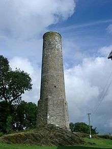 | Castletown-Kinneigh |
51°45′50″N 8°58′31″W / 51.76394°N 8.97539°W / 51.76394; -8.97539 |
| 21 | Timoleague Abbey | Friary (Franciscan) |  | Timoleague |
51°38′35″N 8°45′49″W / 51.64302°N 8.76351°W / 51.64302; -8.76351 |
| 360 | Desmond Castle or The French Prison, Kinsale | Tower House | 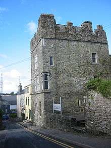 | Kinsale |
51°42′26″N 8°31′29″W / 51.70736°N 8.52484°W / 51.70736; -8.52484 |
| 299 | Tullylease | Church & Grave Slabs | 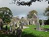 | Tullylease |
52°19′00″N 8°56′23″W / 52.31669°N 8.93965°W / 52.31669; -8.93965 |
| 634 | Michael Collins birth place | Site with historic associations |  | Woodfield |
51°36′40″N 8°58′42″W / 51.61102°N 8.97834°W / 51.61102; -8.97834 |
| 286 | North Abbey, Youghal | Friary (Dominican) |  | Youghal |
51°57′27″N 7°51′16″W / 51.95744°N 7.85454°W / 51.95744; -7.85454 |