List of Scheduled prehistoric Monuments in Powys (Radnorshire)

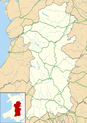
Powys is the largest administrative county in Wales. With an over a quarter of Wales's land area, covering much of the eastern half of the country, it is a county of remote uplands, low population and no coastline. It was created in more or less its current form in 1974, and is the only one of the large county units created at that time to have been carried forward intact at the 1996 local government re-organisation. It comprises three historic counties, namely Montgomeryshire, Radnorshire, and most of Brecknockshire. There are 950 Scheduled monuments within the county, which is far more than can be sensibly covered in one list. Each of the 3 historic counties is therefore listed separately, and each of these has two lists - one for the prehistoric sites and one for the Roman, medieval and post-medieval sites.

This list shows the prehistoric sites in Radnorshire, which occupies the central third of Powys. The River Wye separates it from Brecknockorshire to the south, and Montgomeryshire forms the northern third of Powys. There are 139 prehistoric scheduled monuments in the Radnorshire area. Of these, only two are neolithic burial sites. An extraordinary 117 are likely to date from the Bronze age, mainly burial sites of various sorts but also including a cup-marked stone, 11 stone circles and stone alignments, and 17 standing stones. There are 20 Iron Age hillforts, defensive and other enclosures.

The lists of Scheduled Monuments in Powys are as follows:-

Scheduled Ancient Monuments (SAMs) have statutory protection. It is illegal to disturb the ground surface or any standing remains. The compilation of the list is undertaken by Cadw Welsh Historic Monuments, which is an executive agency of the National Assembly of Wales.[1] The list of scheduled monuments below is supplied by Cadw[2] with additional material from RCAHMW and Clwyd-Powys Archaeological Trust.

Scheduled prehistoric Monuments in Radnorshire

Image Name Site type Community Location Details Period SAM No
& Refs
Clyro Court chambered tomb Chambered tomb Clyro 52°04′52″N 3°09′03″W / 52.0811°N 3.1509°W / 52.0811; -3.1509 (Clyro Court chambered tomb),
SO212431
A long cairn (32m in length) with traces of a chamber. Prehistoric
(Neolithic)
RD203
[3]
Beddau Folau Chambered Tomb Chambered tomb Rhayader 52°16′53″N 3°34′54″W / 52.2815°N 3.5817°W / 52.2815; -3.5817 (Beddau Folau Chambered Tomb),
SN921659
Well preserved Neolithic or Bronze Age tomb next to a public footpath. Four upright slabs remain, and two more lying down. Scheduled in 2003. Also written as Beddaufolau. Prehistoric
(Neolithic)
RD202
[4]
Castell y Garn Round cairn Abbey Cwmhir 52°21′05″N 3°26′32″W / 52.3515°N 3.4421°W / 52.3515; -3.4421 (Castell y Garn),
SO019735
Prehistoric
RD114
[5]
Domen-ddu round barrows Round barrow Abbey Cwmhir 52°23′37″N 3°26′46″W / 52.3936°N 3.4461°W / 52.3936; -3.4461 (Domen-ddu round barrows),
SO016782
Prehistoric
RD248
[6]
Fowler's Arm Chair Stone Circle & Round Cairns, Banc Du Stone circle Abbey Cwmhir 52°24′08″N 3°24′37″W / 52.4021°N 3.4102°W / 52.4021; -3.4102 (Fowler's Arm Chair Stone Circle & Round Cairns, Banc Du),
SO041791
Prehistoric
RD039
[7]
Fuallt Standing Stone Standing stone Abbey Cwmhir 52°24′17″N 3°26′05″W / 52.4047°N 3.4347°W / 52.4047; -3.4347 (Fuallt Standing Stone),
SO024794
Prehistoric
RD193
[8]
Llyn Dwr Cairn Cairn Abbey Cwmhir 52°18′59″N 3°24′00″W / 52.3164°N 3.3999°W / 52.3164; -3.3999 (Llyn Dwr Cairn),
SO046696
Prehistoric
RD161
[9]
Llyn Dwr Standing Stone Standing stone Abbey Cwmhir 52°18′59″N 3°23′55″W / 52.3163°N 3.3985°W / 52.3163; -3.3985 (Llyn Dwr Standing Stone),
SO047696
Prehistoric
RD160
[10]
The Mount Round Barrow near Maes-y-Gwaelod Round barrow Abbey Cwmhir 52°22′07″N 3°27′14″W / 52.3685°N 3.4539°W / 52.3685; -3.4539 (The Mount Round Barrow near Maes-y-Gwaelod),
SO011754
Prehistoric
RD073
[11]
Aberedw Hill Round Barrows Round barrow Aberedw 52°08′15″N 3°20′49″W / 52.1374°N 3.3469°W / 52.1374; -3.3469 (Aberedw Hill Round Barrows),
SO079496
Prehistoric
RD074
[12]
Cefn Wylfre Round Barrows Round barrow Aberedw 52°09′03″N 3°14′59″W / 52.1509°N 3.2498°W / 52.1509; -3.2498 (Cefn Wylfre Round Barrows),
SO145510
Prehistoric
RD178
[13]
Llanbedr Hill Cist Cairn Round cairn Aberedw 52°07′39″N 3°15′42″W / 52.1276°N 3.2616°W / 52.1276; -3.2616 (Llanbedr Hill Cist Cairn),
SO137484
Prehistoric
RD182
[14]
Llwyn-y-wrach standing stone Standing stone Aberedw 52°08′02″N 3°20′42″W / 52.1338°N 3.3451°W / 52.1338; -3.3451 (Llwyn-y-wrach standing stone),
SO080492
Prehistoric
RD243
[15]
Banc Gorddwr, round barrow on NW side of Round barrow Beguildy 52°26′41″N 3°18′35″W / 52.4448°N 3.3097°W / 52.4448; -3.3097 (Banc Gorddwr, round barrow on NW side of),
SO110837
Prehistoric
RD250
[16]
Banc Gorddwr, round barrow on S side of Round barrow Beguildy 52°26′16″N 3°18′28″W / 52.4377°N 3.3079°W / 52.4377; -3.3079 (Banc Gorddwr, round barrow on S side of),
SO111830
Prehistoric
RD251
[17]
Beacon Hill Round Barrows Round barrow Beguildy 52°22′58″N 3°12′41″W / 52.3829°N 3.2114°W / 52.3829; -3.2114 (Beacon Hill Round Barrows),
SO176767
Prehistoric
RD111
[18]
Round Barrow Near Pennant Pound Round barrow Beguildy 52°23′09″N 3°08′37″W / 52.3857°N 3.1437°W / 52.3857; -3.1437 (Round Barrow Near Pennant Pound),
SO222770
Prehistoric
RD090
[19]
Round Barrow S of Meagram's Corner Round barrow Beguildy 52°23′48″N 3°09′46″W / 52.3968°N 3.1627°W / 52.3968; -3.1627 (Round Barrow S of Meagram's Corner),
SO209782
Prehistoric
RD088
[20]
Three Round Barrows NW of Fiddler's Green Farm Round barrow Beguildy 52°25′50″N 3°18′22″W / 52.4305°N 3.3062°W / 52.4305; -3.3062 (Three Round Barrows NW of Fiddler's Green Farm),
SO112821
Prehistoric
RD084
[21]
Warren Hill Round Barrow Round barrow Beguildy 52°23′29″N 3°15′35″W / 52.3914°N 3.2596°W / 52.3914; -3.2596 (Warren Hill Round Barrow),
SO143777
Prehistoric
RD105
[22]
Llwyn-Ceubren Round Barrow Round barrow Disserth and Trecoed 52°13′17″N 3°22′38″W / 52.2213°N 3.3773°W / 52.2213; -3.3773 (Llwyn-Ceubren Round Barrow),
SO060590
Prehistoric
RD127
[23]
Two Cooking Mounds 350m W of Llwynceubren, Howey Burnt mound Disserth and Trecoed 52°13′18″N 3°22′35″W / 52.2218°N 3.3764°W / 52.2218; -3.3764 (Two Cooking Mounds 350m W of Llwynceubren, Howey),
SO060590
Prehistoric
RD141
[24]
Gilwern Brook round barrow Round barrow Gladestry 52°11′51″N 3°11′38″W / 52.1974°N 3.1938°W / 52.1974; -3.1938 (Gilwern Brook round barrow),
SO185561
Prehistoric
RD242
[25]
Llanfihangel Hill round barrow Round barrow Gladestry 52°11′33″N 3°11′12″W / 52.1926°N 3.1867°W / 52.1926; -3.1867 (Llanfihangel Hill round barrow),
SO189555
Prehistoric
RD241
[26]
Maesgwyn round barrow Round barrow Glasbury 52°05′02″N 3°13′18″W / 52.084°N 3.2218°W / 52.084; -3.2218 (Maesgwyn round barrow),
SO163435
Prehistoric
RD246
[27]
Neuadd-Glan-Gwy Standing Stone Standing stone Glasbury 52°03′43″N 3°16′33″W / 52.062°N 3.2757°W / 52.062; -3.2757 (Neuadd-Glan-Gwy Standing Stone),
SO126411
Prehistoric
RD128
[28]
Bryntwppa stone row Stone row Glascwm 52°10′41″N 3°19′56″W / 52.1781°N 3.3323°W / 52.1781; -3.3323 (Bryntwppa stone row),
SO089541
Prehistoric
RD236
[29]
Carneddau round cairns Round cairn Glascwm 52°10′52″N 3°22′18″W / 52.1811°N 3.3718°W / 52.1811; -3.3718 (Carneddau round cairns),
SO063545
Prehistoric
RD235
[30]
Carneddau, cairn on N end of Round cairn Glascwm 52°11′16″N 3°21′58″W / 52.1877°N 3.3661°W / 52.1877; -3.3661 (Carneddau, cairn on N end of),
SO067552
Prehistoric
RD221
[31]
Carneddau, round cairn on N end of Round cairn Glascwm 52°11′21″N 3°22′01″W / 52.1893°N 3.367°W / 52.1893; -3.367 (Carneddau, round cairn on N end of),
SO066554
Prehistoric
RD220
[32]
Castle Bank ring cairn Ring cairn Glascwm 52°11′19″N 3°20′27″W / 52.1885°N 3.3408°W / 52.1885; -3.3408 (Castle Bank ring cairn),
SO084553
Prehistoric
RD228
[33]
Cefn Wylfre Stone Circle and Round Barrow Stone circle Glascwm 52°09′04″N 3°15′30″W / 52.1511°N 3.2583°W / 52.1511; -3.2583 (Cefn Wylfre Stone Circle and Round Barrow),
SO140510
Prehistoric
RD177
[34]
Cilberllan ring cairn Ring cairn Glascwm 52°10′50″N 3°20′44″W / 52.1806°N 3.3455°W / 52.1806; -3.3455 (Cilberllan ring cairn),
SO081544
Prehistoric
RD226
[35]
Court standing stone Standing stone Glascwm 52°12′08″N 3°20′26″W / 52.2021°N 3.3406°W / 52.2021; -3.3406 (Court standing stone),
SO084568
Prehistoric
RD225
[36]
Court stone row Stone row Glascwm 52°12′11″N 3°20′06″W / 52.2031°N 3.3349°W / 52.2031; -3.3349 (Court stone row),
SO088569
Prehistoric
RD224
[37]
Cwm standing stone Standing stone Glascwm 52°11′52″N 3°18′56″W / 52.1977°N 3.3156°W / 52.1977; -3.3156 (Cwm standing stone),
SO101563
Prehistoric
RD229
[38]
Cwm-berwyn round cairn Round cairn Glascwm 52°10′45″N 3°21′07″W / 52.1793°N 3.3519°W / 52.1793; -3.3519 (Cwm-berwyn round cairn),
SO076543
Prehistoric
RD222
[39]
Cwm-Maerdy Standing Stone Standing stone Glascwm 52°13′15″N 3°15′27″W / 52.2207°N 3.2574°W / 52.2207; -3.2574 (Cwm-Maerdy Standing Stone),
SO142587
Prehistoric
RD113
[40]
Gelli Hill Round Barrow Round barrow Glascwm 52°12′55″N 3°19′13″W / 52.2154°N 3.3203°W / 52.2154; -3.3203 (Gelli Hill Round Barrow),
SO098582
Prehistoric
RD034
[41]
Gelli Hill Stone Circle Stone circle Glascwm 52°12′59″N 3°19′31″W / 52.2163°N 3.3252°W / 52.2163; -3.3252 (Gelli Hill Stone Circle),
SO095583
Prehistoric
RD028
[42]
Giant's Grave round cairn Round cairn Glascwm 52°10′52″N 3°15′32″W / 52.181°N 3.2589°W / 52.181; -3.2589 (Giant's Grave round cairn),
SO140543
Prehistoric
RD218
[43]
Gilwern Hill round cairn Round cairn Glascwm 52°13′09″N 3°19′44″W / 52.2191°N 3.329°W / 52.2191; -3.329 (Gilwern Hill round cairn),
SO093587
Prehistoric
RD239
[44]
Gilwern Hill, Round Cairn on NE of Round cairn Glascwm 52°13′22″N 3°19′16″W / 52.2227°N 3.3211°W / 52.2227; -3.3211 (Gilwern Hill, Round Cairn on NE of),
SO098590
Prehistoric
RD240
[45]
Gwernfach round cairn Round cairn Glascwm 52°12′08″N 3°19′22″W / 52.2021°N 3.3229°W / 52.2021; -3.3229 (Gwernfach round cairn),
SO096568
Prehistoric
RD227
[46]
Hundred House round barrow Round barrow Glascwm 52°10′47″N 3°17′55″W / 52.1798°N 3.2985°W / 52.1798; -3.2985 (Hundred House round barrow),
SO113543
Prehistoric
RD230
[47]
Six Stones Stone Circle Stone circle Glascwm 52°09′25″N 3°13′30″W / 52.157°N 3.2251°W / 52.157; -3.2251 (Six Stones Stone Circle),
SO162516
Prehistoric
RD026
[48]
The Fedw Stone Circle 360m W of Llanboidy Wood Stone circle Glascwm 52°12′48″N 3°15′19″W / 52.2132°N 3.2554°W / 52.2132; -3.2554 (The Fedw Stone Circle 360m W of Llanboidy Wood),
SO143579
Prehistoric
RD027
[49]
Upper House round cairns Round cairn Glascwm 52°12′13″N 3°20′57″W / 52.2036°N 3.3491°W / 52.2036; -3.3491 (Upper House round cairns),
SO079570
Prehistoric
RD223
[50]
Coventry Round Barrow Round barrow Llanbadarn Fynydd 52°24′19″N 3°16′50″W / 52.4052°N 3.2805°W / 52.4052; -3.2805 (Coventry Round Barrow),
SO129793
Prehistoric
RD103
[51]
Moel Dod round barrow Round barrow Llanbadarn Fynydd 52°22′46″N 3°21′23″W / 52.3794°N 3.3565°W / 52.3794; -3.3565 (Moel Dod round barrow),
SO077765
Prehistoric
RD249
[52]
Cae-glas Round Barrows Round barrow Llanbister 52°23′37″N 3°15′58″W / 52.3935°N 3.2662°W / 52.3935; -3.2662 (Cae-glas Round Barrows),
SO138780
Prehistoric
RD104
[53]
Gors Lydan Round Barrows Round barrow Llanbister 52°22′58″N 3°17′07″W / 52.3828°N 3.2853°W / 52.3828; -3.2853 (Gors Lydan Round Barrows),
SO126768
Prehistoric
RD106
[54]
Rhos Crug Round Barrows Round barrow Llanbister 52°21′40″N 3°13′28″W / 52.3612°N 3.2245°W / 52.3612; -3.2245 (Rhos Crug Round Barrows),
SO167743
Prehistoric
RD110
[55]
Round Barrow to W of Ty'n-y-ddol Hill Round barrow Llanbister 52°24′10″N 3°16′38″W / 52.4028°N 3.2771°W / 52.4028; -3.2771 (Round Barrow to W of Ty'n-y-ddol Hill),
SO132790
Prehistoric
RD252
[56]
Bongam Bank Round Barrows Round barrow Llandrindod Wells 52°14′30″N 3°21′06″W / 52.2417°N 3.3518°W / 52.2417; -3.3518 (Bongam Bank Round Barrows),
SO077612
Prehistoric
RD007
[57]
Broomy Hill standing stone Standing stone Llandrindod Wells 52°13′34″N 3°21′38″W / 52.2262°N 3.3606°W / 52.2262; -3.3606 (Broomy Hill standing stone),
SO071595
Prehistoric
RD232
[58]
Broomy Hill, standing stone on N Standing stone Llandrindod Wells 52°13′45″N 3°21′34″W / 52.2293°N 3.3595°W / 52.2293; -3.3595 (Broomy Hill, standing stone on N),
SO072598
Prehistoric
RD233
[59]
Broomy Hill, standing stone on S Standing stone Llandrindod Wells 52°13′21″N 3°21′51″W / 52.2225°N 3.3643°W / 52.2225; -3.3643 (Broomy Hill, standing stone on S),
SO069591
Prehistoric
RD231
[60]
Little Hill Round Barrows Round barrow Llandrindod Wells 52°13′37″N 3°21′29″W / 52.227°N 3.358°W / 52.227; -3.358 (Little Hill Round Barrows),
SO073596
Prehistoric
RD009
[61]
Pant Purlas Round Barrow Round barrow Llandrindod Wells 52°14′20″N 3°21′21″W / 52.2389°N 3.3557°W / 52.2389; -3.3557 (Pant Purlas Round Barrow),
SO075609
Prehistoric
RD010
[62]
Carneddau Round Cairn Round cairn Llanelwedd 52°10′37″N 3°22′01″W / 52.177°N 3.367°W / 52.177; -3.367 (Carneddau Round Cairn),
SO066540
Prehistoric
RD122
[63]
Carneddau, standing stone to SSW of Standing stone Llanelwedd 52°10′17″N 3°22′28″W / 52.1713°N 3.3744°W / 52.1713; -3.3744 (Carneddau, standing stone to SSW of),
SO061534
Prehistoric
RD219
[64]
Black Mixen, round barrow to NW of Round barrow Llanfihangel Rhydithon 52°16′44″N 3°11′14″W / 52.279°N 3.1873°W / 52.279; -3.1873 (Black Mixen, round barrow to NW of),
SO190652
Prehistoric
RD256
[65]
Cwm Bwch round barrow pair Round barrow Llanfihangel Rhydithon 52°16′36″N 3°12′34″W / 52.2766°N 3.2095°W / 52.2766; -3.2095 (Cwm Bwch round barrow pair),
SO175649
Prehistoric
RD255
[66]
Great Rhos Round Barrow Round barrow Llanfihangel Rhydithon 52°16′09″N 3°12′34″W / 52.2693°N 3.2094°W / 52.2693; -3.2094 (Great Rhos Round Barrow),
SO175641
Prehistoric
RD254
[67]
Shepherd's Tump Round Barrow Round barrow Llanfihangel Rhydithon 52°16′49″N 3°14′24″W / 52.2802°N 3.2399°W / 52.2802; -3.2399 (Shepherd's Tump Round Barrow),
SO155653
Prehistoric
RD253
[68]
Dol-y-Fan Round Cairn Round cairn Llanyre 52°14′30″N 3°26′15″W / 52.2416°N 3.4375°W / 52.2416; -3.4375 (Dol-y-Fan Round Cairn),
SO019613
Prehistoric
RD125
[69]
Carn Wen cairn Kerb cairn Nantmel 52°17′03″N 3°29′12″W / 52.2841°N 3.4867°W / 52.2841; -3.4867 (Carn Wen cairn),
SN986661
Prehistoric
RD205
[70]
Round Barrow NE of Cefn-Ceido Hall Round barrow Nantmel 52°18′17″N 3°29′25″W / 52.3046°N 3.4902°W / 52.3046; -3.4902 (Round Barrow NE of Cefn-Ceido Hall),
SN984684
Prehistoric
RD083
[71]
Ty-Lettice Round Barrow Round barrow Nantmel 52°18′24″N 3°28′57″W / 52.3068°N 3.4824°W / 52.3068; -3.4824 (Ty-Lettice Round Barrow),
SN990686
Prehistoric
RD082
[72]
Black Mixen Round Barrow Round barrow New Radnor 52°16′18″N 3°10′44″W / 52.2718°N 3.179°W / 52.2718; -3.179 (Black Mixen Round Barrow),
SO196643
Prehistoric
RD257
[73]
Bryn y Maen Alignment (Four Stones) Stone alignment New Radnor 52°12′11″N 3°14′10″W / 52.2031°N 3.236°W / 52.2031; -3.236 (Bryn y Maen Alignment (Four Stones)),
SO156568
Prehistoric
RD069
[74]
Bryn y Maen Round Barrow Round barrow New Radnor 52°12′13″N 3°14′07″W / 52.2035°N 3.2354°W / 52.2035; -3.2354 (Bryn y Maen Round Barrow),
SO156565
Prehistoric
RD109
[75]
Llannerch cup-marked rock Cup-marked stone New Radnor 52°13′08″N 3°14′05″W / 52.2189°N 3.2347°W / 52.2189; -3.2347 (Llannerch cup-marked rock),
SO157585
Prehistoric
RD234
[76]
The Whimble Barrow Round barrow New Radnor 52°15′22″N 3°09′57″W / 52.2562°N 3.1659°W / 52.2562; -3.1659 (The Whimble Barrow),
SO205626
Prehistoric
RD191
[77]
Bronze Age Round Barrows on Whinyard Rocks Round barrow Old Radnor 52°15′40″N 3°09′40″W / 52.261°N 3.1612°W / 52.261; -3.1612 (Bronze Age Round Barrows on Whinyard Rocks),
SO208631
Prehistoric
RD190
[78]
Hindwell Farm Round Barrows Round barrow Old Radnor 52°14′29″N 3°05′47″W / 52.2414°N 3.0965°W / 52.2414; -3.0965 (Hindwell Farm Round Barrows),
SO252609
Prehistoric
RD063
[79]
Red Hill Bronze Age Barrows Round barrow Old Radnor 52°15′55″N 3°09′12″W / 52.2653°N 3.1533°W / 52.2653; -3.1533 (Red Hill Bronze Age Barrows),
SO214636
Prehistoric
RD189
[80]
Standing Stone 400m ENE of Four Stones Standing stone Old Radnor 52°14′29″N 3°06′04″W / 52.2414°N 3.1011°W / 52.2414; -3.1011 (Standing Stone 400m ENE of Four Stones),
SO249609
Prehistoric
RD064
[81]
The Four Kings - geograph.org.uk - 413375.jpg
Four Stones Standing stone Old Radnor 52°14′25″N 3°06′21″W / 52.2402°N 3.1059°W / 52.2402; -3.1059 (The Four Stones),
SO245607
Four regularly spaced stones set as corners of a rectangle (or 'four-poster stone circle'). The name 'Four Stones' has been in use at least since the 17th century. Prehistoric
RD004
[82]
Two Round Barrows NE of Harpton Court Round barrow Old Radnor 52°14′00″N 3°06′57″W / 52.2334°N 3.1157°W / 52.2334; -3.1157 (Two Round Barrows NE of Harpton Court),
SO238600
Prehistoric
RD048
[83]
Worsell Wood cairn cemetery Round cairn Old Radnor 52°12′48″N 3°05′13″W / 52.2134°N 3.087°W / 52.2134; -3.087 (Worsell Wood cairn cemetery),
SO258577
Prehistoric
RD151
[84]
Bailey Bedw Ring Cairn Ring cairn Painscastle 52°05′23″N 3°13′13″W / 52.0897°N 3.2202°W / 52.0897; -3.2202 (Bailey Bedw Ring Cairn),
SO164441
Prehistoric
RD180
[85]
Begwns round cairn Round cairn Painscastle 52°05′42″N 3°14′12″W / 52.0951°N 3.2368°W / 52.0951; -3.2368 (Begwns round cairn),
SO153448
Prehistoric
RD245
[86]
Begwns standing stone Standing stone Painscastle 52°05′48″N 3°14′20″W / 52.0967°N 3.2389°W / 52.0967; -3.2389 (Begwns standing stone),
SO152449
Prehistoric
RD244
[87]
Blaenhenllan round cairn Round cairn Painscastle 52°06′06″N 3°18′36″W / 52.1017°N 3.31°W / 52.1017; -3.31 (Blaenhenllan round cairn),
SO103456
Prehistoric
RD217
[88]
Lane Farm Round Barrow Round barrow Painscastle 52°07′04″N 3°11′53″W / 52.1177°N 3.198°W / 52.1177; -3.198 (Lane Farm Round Barrow),
SO180472
Prehistoric
RD144
[89]
Twyn y Garth Round Barrows Round barrow Painscastle 52°05′05″N 3°18′13″W / 52.0848°N 3.3035°W / 52.0848; -3.3035 (Twyn y Garth Round Barrows),
SO107437
Prehistoric
RD065
[90]
Cwmbrith Round Cairn Round cairn Penybont 52°14′07″N 3°20′19″W / 52.2352°N 3.3386°W / 52.2352; -3.3386 (Cwmbrith Round Cairn),
SO086605
Prehistoric
RD156
[91]
Ffrwd standing stone Standing stone Penybont 52°13′48″N 3°19′59″W / 52.23°N 3.3331°W / 52.23; -3.3331 (Ffrwd standing stone),
SO090599
Prehistoric
RD238
[92]
Pawl Hir Ring Cairn Ring cairn Penybont 52°13′36″N 3°19′03″W / 52.2268°N 3.3175°W / 52.2268; -3.3175 (Pawl Hir Ring Cairn),
SO101595
Prehistoric
RD167
[93]
Carn Nant-y-ffald cairn Round cairn Rhayader 52°21′10″N 3°36′57″W / 52.3528°N 3.6158°W / 52.3528; -3.6158 (Carn Nant-y-ffald cairn),
SN900739
Prehistoric
RD207
[94]
Carn Wen cairn Platform Cairn Rhayader 52°21′06″N 3°36′44″W / 52.3516°N 3.6123°W / 52.3516; -3.6123 (Carn Wen cairn),
SN902738
Prehistoric
RD206
[95]
Carn y Groes cairn Round cairn Rhayader 52°22′29″N 3°38′44″W / 52.3747°N 3.6456°W / 52.3747; -3.6456 (Carn y Groes cairn),
SN880764
Prehistoric
RD208
[96]
Carreg Bica Round Cairn Round cairn Rhayader 52°16′38″N 3°34′38″W / 52.2772°N 3.5773°W / 52.2772; -3.5773 (Carreg Bica Round Cairn),
SN924655
Prehistoric
RD200
[97]
Cefn Llanerchi Standing Stones Stone alignment Rhayader 52°15′31″N 3°36′55″W / 52.2587°N 3.6154°W / 52.2587; -3.6154 (Cefn Llanerchi Standing Stones),
SN898635
Prehistoric
RD198
[98]
Cefn Troedrhiw-drain cist Cist burial Rhayader 52°17′13″N 3°37′53″W / 52.2869°N 3.6315°W / 52.2869; -3.6315 (Cefn Troedrhiw-drain cist),
SN888666
Prehistoric
RD214
[99]
Cistfaen barrows Round barrow Rhayader 52°22′41″N 3°40′12″W / 52.378°N 3.67°W / 52.378; -3.67 (Cistfaen barrows),
SN864768
Prehistoric
RD210
[100]
Cistfaen cairns Round cairn Rhayader 52°22′45″N 3°40′15″W / 52.3793°N 3.6708°W / 52.3793; -3.6708 (Cistfaen cairns),
SN863770
Prehistoric
RD209
[101]
Clap yr Arian cairn Round cairn Rhayader 52°19′02″N 3°33′43″W / 52.3173°N 3.5619°W / 52.3173; -3.5619 (Clap yr Arian cairn),
SN936699
Prehistoric
RD212
[102]
Esgair Beddau cairns Round cairn Rhayader 52°18′26″N 3°39′57″W / 52.3071°N 3.6659°W / 52.3071; -3.6659 (Esgair Beddau cairns),
SN865689
Prehistoric
RD216
[103]
Glog Fawr Platform Cairn Platform Cairn Rhayader 52°16′54″N 3°34′40″W / 52.2818°N 3.5778°W / 52.2818; -3.5778 (Glog Fawr Platform Cairn),
SN924660
Prehistoric
RD201
[104]
Nant Cletwr barrow Round barrow Rhayader 52°18′20″N 3°39′23″W / 52.3055°N 3.6565°W / 52.3055; -3.6565 (Nant Cletwr barrow),
SN871687
Prehistoric
RD215
[105]
Nant Gwynllyn Standing stone Standing stone Rhayader 52°18′55″N 3°34′05″W / 52.3153°N 3.568°W / 52.3153; -3.568 (Nant Gwynllyn Standing stone),
SN932697
Prehistoric
RD196
[106]
Nant y Llyn cist Cist burial Rhayader 52°18′30″N 3°34′09″W / 52.3082°N 3.5691°W / 52.3082; -3.5691 (Nant y Llyn cist),
SN931689
Prehistoric
RD211
[107]
Nant y Llyn Stone Row Stone alignment Rhayader 52°18′28″N 3°34′09″W / 52.3079°N 3.5691°W / 52.3079; -3.5691 (Nant y Llyn Stone Row),
SN931689
Prehistoric
RD197
[108]
Rhos y Gelynnen Ring Cairn Ring cairn Rhayader 52°15′17″N 3°36′14″W / 52.2547°N 3.6039°W / 52.2547; -3.6039 (Rhos y Gelynnen Ring Cairn),
SN906630
Prehistoric
RD194
[109]
Rhos y Gelynnen Stone Row Stone row Rhayader 52°15′18″N 3°36′18″W / 52.2549°N 3.605°W / 52.2549; -3.605 (Rhos y Gelynnen Stone Row),
SN905630
Prehistoric
RD195
[110]
Y Glog Fawr cairn Round cairn Rhayader 52°17′00″N 3°34′58″W / 52.2832°N 3.5828°W / 52.2832; -3.5828 (Y Glog Fawr cairn),
SN921661
Prehistoric
RD213
[111]
Bronze Age round barrow NW of Glan-marteg Round barrow St Harmon 52°21′18″N 3°28′50″W / 52.3551°N 3.4805°W / 52.3551; -3.4805 (Bronze Age round barrow NW of Glan-marteg),
SN992740
Prehistoric
RD042
[112]
Bronze Age tumulus north of Beili Haulwen Round barrow St Harmon 52°21′36″N 3°28′35″W / 52.3599°N 3.4763°W / 52.3599; -3.4763 (Bronze Age tumulus north of Beili Haulwen),
SN995745
Prehistoric
RD192
[113]
Cnych Round Barrow Round barrow St Harmon 52°22′07″N 3°28′48″W / 52.3687°N 3.4799°W / 52.3687; -3.4799 (Cnych Round Barrow),
SN993755
Prehistoric
RD115
[114]
Creggin Round Barrow Round barrow St Harmon 52°19′33″N 3°29′54″W / 52.3259°N 3.4983°W / 52.3259; -3.4983 (Creggin Round Barrow),
SN979708
Prehistoric
RD078
[115]
Crugyn Tumulus Round barrow St Harmon 52°20′23″N 3°29′41″W / 52.3397°N 3.4948°W / 52.3397; -3.4948 (Crugyn Tumulus),
SN982723
Prehistoric
RD040
[116]
Cwm y Saeson Standing Stone Standing stone St Harmon 52°22′51″N 3°32′34″W / 52.3808°N 3.5429°W / 52.3808; -3.5429 (Cwm y Saeson Standing Stone),
SN950769
Prehistoric
RD119
[117]
Pont Marteg, cairn circle to E of Cairn circle St Harmon 52°19′56″N 3°31′42″W / 52.3323°N 3.5282°W / 52.3323; -3.5282 (Pont Marteg, cairn circle to E of),
SN959715
Prehistoric
RD204
[118]
Round Barrow 400m NNW of Beili Hwlyn Round barrow St Harmon 52°21′16″N 3°29′02″W / 52.3544°N 3.4839°W / 52.3544; -3.4839 (Round Barrow 400m NNW of Beili Hwlyn),
SN990739
Prehistoric
RD041
[119]
Standing Stone & Round Barrow SE of Henriw Round barrow St Harmon 52°23′10″N 3°31′24″W / 52.3862°N 3.5234°W / 52.3862; -3.5234 (Standing Stone & Round Barrow SE of Henriw),
SN964775
Prehistoric
RD070
[120]
Llethrau Camp Enclosure Beguildy 52°26′28″N 3°15′51″W / 52.441°N 3.2641°W / 52.441; -3.2641 (Llethrau Camp),
SO141833
Prehistoric
RD107
[121]
Tyn'n-y-Cwm Camp Enclosure Beguildy 52°26′33″N 3°14′49″W / 52.4426°N 3.247°W / 52.4426; -3.247 (Tyn'n-y-Cwm Camp),
SO153834
Prehistoric
RD120
[122]
Castle Bank Hillfort Hillfort Glascwm 52°11′43″N 3°20′14″W / 52.1954°N 3.3373°W / 52.1954; -3.3373 (Castle Bank Hillfort),
SO086560
Prehistoric
RD149
[123]
Cwm Berwyn Camp Hillfort Glascwm 52°11′03″N 3°21′28″W / 52.1841°N 3.3578°W / 52.1841; -3.3578 (Cwm Berwyn Camp),
SO072548
Prehistoric
RD123
[124]
Graig Camp Hillfort Glascwm 52°13′02″N 3°16′22″W / 52.2171°N 3.2729°W / 52.2171; -3.2729 (Graig Camp),
SO131584
Prehistoric
RD112
[125]
The Gaer hillfort Hillfort Glascwm 52°11′03″N 3°20′21″W / 52.1841°N 3.3392°W / 52.1841; -3.3392 (The Gaer hillfort),
SO085548
Prehistoric
RD237
[126]
Wern Camp Hillfort Glascwm 52°10′28″N 3°13′33″W / 52.1745°N 3.2259°W / 52.1745; -3.2259 (Wern Camp),
SO162536
Prehistoric
RD130
[127]
Castell Tinboeth Hillfort Llanbadarn Fynydd 52°22′10″N 3°20′14″W / 52.3694°N 3.3371°W / 52.3694; -3.3371 (Castell Tinboeth),
SO090754
Prehistoric
RD038
[128]
Castell y Blaidd Enclosure Llanbadarn Fynydd 52°24′33″N 3°17′17″W / 52.4092°N 3.2881°W / 52.4092; -3.2881 (Castell y Blaidd),
SO124797
Prehistoric
RD102
[129]
Camp SW of Castell Cwm Aran Hillfort Llanddewi Ystradenny 52°19′20″N 3°15′15″W / 52.3223°N 3.2542°W / 52.3223; -3.2542 (Camp SW of Castell Cwm Aran),
SO146700
Prehistoric
RD094
[130]
Camp W of Cwm Cefn y Gaer Hillfort Llanddewi Ystradenny 52°19′09″N 3°18′01″W / 52.3193°N 3.3004°W / 52.3193; -3.3004 (Camp W of Cwm Cefn y Gaer),
SO114698
Prehistoric
RD093
[131]
Cwm Cefn y Gaer Hillfort Llanddewi Ystradenny 52°19′14″N 3°17′26″W / 52.3206°N 3.2905°W / 52.3206; -3.2905 (Cwm Cefn y Gaer),
SO121699
Prehistoric
RD011
[132]
Carreg-Wiber Bank Earthwork Earthwork (unclassified) Llandrindod Wells 52°13′34″N 3°20′33″W / 52.2261°N 3.3425°W / 52.2261; -3.3425 (Carreg-Wiber Bank Earthwork),
SO084595
Prehistoric
RD031
[133]
Caer Einon Camp Hillfort Llanelwedd 52°10′04″N 3°22′13″W / 52.1677°N 3.3703°W / 52.1677; -3.3703 (Caer Einon Camp),
SO063530
Prehistoric
RD014
[134]
Glog Camp Enclosure Llangunllo 52°18′48″N 3°07′38″W / 52.3132°N 3.1272°W / 52.3132; -3.1272 (Glog Camp),
SO232689
Prehistoric
RD098
[135]
Water-Break-its-Neck Promontory Fort Promontory fort - inland Llangunllo 52°21′14″N 3°12′06″W / 52.354°N 3.2016°W / 52.354; -3.2016 (Water-Break-its-Neck Promontory Fort),
SO182735
Prehistoric
RD265
[136]
Burfa Camp Hillfort Old Radnor 52°14′34″N 3°03′00″W / 52.2429°N 3.0499°W / 52.2429; -3.0499 (Burfa Camp),
SO284610
Prehistoric
RD013
[137]
Castle Ring Enclosure Old Radnor 52°15′57″N 3°04′34″W / 52.2657°N 3.0762°W / 52.2657; -3.0762 (Castle Ring),
SO266636
Prehistoric
RD062
[138]
Hindwell Palisaded Enclosure Palisaded Enclosure Old Radnor 52°14′22″N 3°05′37″W / 52.2395°N 3.0935°W / 52.2395; -3.0935 (Hindwell Palisaded Enclosure),
SO254607
Prehistoric
RD247
[139]
Coed-swydd Enclosure Enclosure - Defensive Penybont 52°16′24″N 3°15′59″W / 52.2734°N 3.2665°W / 52.2734; -3.2665 (Coed-swydd Enclosure),
SO136646
Prehistoric
RD262
[140]
Llandegley Rocks Hillfort Hillfort Penybont 52°14′54″N 3°16′07″W / 52.2482°N 3.2685°W / 52.2482; -3.2685 (Llandegley Rocks Hillfort),
SO135619
Prehistoric
RD264
[141]
Clyro Court chambered tomb
Beddau Folau Chambered Tomb
Castell y Garn
Domen-ddu round barrows
Fowler's Arm Chair Stone Circle & Round Cairns, Banc Du
Fuallt Standing Stone
Llyn Dwr Cairn
Llyn Dwr Standing Stone
The Mount Round Barrow near Maes-y-Gwaelod
Aberedw Hill Round Barrows
Cefn Wylfre Round Barrows
Llanbedr Hill Cist Cairn
Llwyn-y-wrach standing stone
Banc Gorddwr, round barrow on NW side of
Banc Gorddwr, round barrow on S side of
Beacon Hill Round Barrows
Round Barrow Near Pennant Pound
Round Barrow S of Meagram's Corner
Three Round Barrows NW of Fiddler's Green Farm
Warren Hill Round Barrow
Llwyn-Ceubren Round Barrow
Two Cooking Mounds 350m W of Llwynceubren, Howey
Gilwern Brook round barrow
Llanfihangel Hill round barrow
Maesgwyn round barrow
Neuadd-Glan-Gwy Standing Stone
Bryntwppa stone row
Carneddau round cairns
Carneddau, cairn on N end of
Carneddau, round cairn on N end of
Castle Bank ring cairn
Cefn Wylfre Stone Circle and Round Barrow
Cilberllan ring cairn
Court standing stone
Court stone row
Cwm standing stone
Cwm-berwyn round cairn
Cwm-Maerdy Standing Stone
Gelli Hill Round Barrow
Gelli Hill Stone Circle
Giant's Grave round cairn
Gilwern Hill round cairn
Gilwern Hill, Round Cairn on NE of
Gwernfach round cairn
Hundred House round barrow
Six Stones Stone Circle
The Fedw Stone Circle 360m W of Llanboidy Wood
Upper House round cairns
Coventry Round Barrow
Moel Dod round barrow
Cae-glas Round Barrows
Gors Lydan Round Barrows
Rhos Crug Round Barrows
Round Barrow to W of Ty'n-y-ddol Hill
Bongam Bank Round Barrows
Broomy Hill standing stone
Broomy Hill, standing stone on N
Broomy Hill, standing stone on S
Little Hill Round Barrows
Pant Purlas Round Barrow
Carneddau Round Cairn
Carneddau, standing stone to SSW of
Black Mixen, round barrow to NW of
Cwm Bwch round barrow pair
Great Rhos Round Barrow
Shepherd's Tump Round Barrow
Dol-y-Fan Round Cairn
Carn Wen cairn
Round Barrow NE of Cefn-Ceido Hall
Ty-Lettice Round Barrow
Black Mixen Round Barrow
Bryn y Maen Alignment (Four Stones)
Bryn y Maen Round Barrow
Llannerch cup-marked rock
The Whimble Barrow
Bronze Age Round Barrows on Whinyard Rocks
Hindwell Farm Round Barrows
Red Hill Bronze Age Barrows
Standing Stone 400m ENE of Four Stones
The Four Stones
Two Round Barrows NE of Harpton Court
Worsell Wood cairn cemetery
Bailey Bedw Ring Cairn
Begwns round cairn
Begwns standing stone
Blaenhenllan round cairn
Lane Farm Round Barrow
Twyn y Garth Round Barrows
Cwmbrith Round Cairn
Ffrwd standing stone
Pawl Hir Ring Cairn
Carn Nant-y-ffald cairn
Carn Wen cairn
Carn y Groes cairn
Carreg Bica Round Cairn
Cefn Llanerchi Standing Stones
Cefn Troedrhiw-drain cist
Cistfaen barrows
Cistfaen cairns
Clap yr Arian cairn
Esgair Beddau cairns
Glog Fawr Platform Cairn
Nant Cletwr barrow
Nant Gwynllyn Standing stone
Nant y Llyn cist
Nant y Llyn Stone Row
Rhos y Gelynnen Ring Cairn
Rhos y Gelynnen Stone Row
Y Glog Fawr cairn
Bronze Age round barrow NW of Glan-marteg
Bronze Age tumulus north of Beili Haulwen
Cnych Round Barrow
Creggin Round Barrow
Crugyn Tumulus
Cwm y Saeson Standing Stone
Pont Marteg, cairn circle to E of
Round Barrow 400m NNW of Beili Hwlyn
Standing Stone & Round Barrow SE of Henriw
Llethrau Camp
Tyn'n-y-Cwm Camp
Castle Bank Hillfort
Cwm Berwyn Camp
Graig Camp
The Gaer hillfort
Wern Camp
Castell Tinboeth
Castell y Blaidd
Camp SW of Castell Cwm Aran
Camp W of Cwm Cefn y Gaer
Cwm Cefn y Gaer
Carreg-Wiber Bank Earthwork
Caer Einon Camp
Glog Camp
Water-Break-its-Neck Promontory Fort
Burfa Camp
Castle Ring
Hindwell Palisaded Enclosure
Coed-swydd Enclosure
Llandegley Rocks Hillfort
Scheduled Monuments in Powys, Wales.
=Neolithic =Bronze Age =Iron Age

See also

References

  1. Cadw: Ancient Monuments and Scheduling. Accessed 25 April 2013
  2. Cadw will send their list as a spreadsheet, or other electronic formats, on request, as indicated at www.whatdotheyknow.com. This list uses information dated May 2012
  3. coflein NPRN: 306309. GGAT PRN not yet identified. Cadw SAM: RD203: Clyro Court chambered tomb
  4. coflein NPRN: 261705. GGAT PRN not yet identified. Cadw SAM: RD202: Beddau Folau Chambered Tomb
  5. coflein NPRN: not yet identified. GGAT PRN not yet identified. Cadw SAM: RD114: Castell y Garn
  6. coflein NPRN: not yet identified. GGAT PRN not yet identified. Cadw SAM: RD248: Domen-ddu round barrows
  7. coflein NPRN: not yet identified. GGAT PRN not yet identified. Cadw SAM: RD039: Fowler's Arm Chair Stone Circle & Round Cairns, Banc Du
  8. coflein NPRN: not yet identified. GGAT PRN not yet identified. Cadw SAM: RD193: Fuallt Standing Stone
  9. coflein NPRN: not yet identified. GGAT PRN not yet identified. Cadw SAM: RD161: Llyn Dwr Cairn
  10. coflein NPRN: not yet identified. GGAT PRN not yet identified. Cadw SAM: RD160: Llyn Dwr Standing Stone
  11. coflein NPRN: not yet identified. GGAT PRN not yet identified. Cadw SAM: RD073: The Mount Round Barrow near Maes-y-Gwaelod
  12. coflein NPRN: not yet identified. GGAT PRN not yet identified. Cadw SAM: RD074: Aberedw Hill Round Barrows
  13. coflein NPRN: not yet identified. GGAT PRN not yet identified. Cadw SAM: RD178: Cefn Wylfre Round Barrows
  14. coflein NPRN: not yet identified. GGAT PRN not yet identified. Cadw SAM: RD182: Llanbedr Hill Cist Cairn
  15. coflein NPRN: not yet identified. GGAT PRN not yet identified. Cadw SAM: RD243: Llwyn-y-wrach standing stone
  16. coflein NPRN: not yet identified. GGAT PRN not yet identified. Cadw SAM: RD250: Banc Gorddwr, round barrow on NW side of
  17. coflein NPRN: not yet identified. GGAT PRN not yet identified. Cadw SAM: RD251: Banc Gorddwr, round barrow on S side of
  18. coflein NPRN: not yet identified. GGAT PRN not yet identified. Cadw SAM: RD111: Beacon Hill Round Barrows
  19. coflein NPRN: not yet identified. GGAT PRN not yet identified. Cadw SAM: RD090: Round Barrow Near Pennant Pound
  20. coflein NPRN: not yet identified. GGAT PRN not yet identified. Cadw SAM: RD088: Round Barrow S of Meagram's Corner
  21. coflein NPRN: not yet identified. GGAT PRN not yet identified. Cadw SAM: RD084: Three Round Barrows NW of Fiddler's Green Farm
  22. coflein NPRN: not yet identified. GGAT PRN not yet identified. Cadw SAM: RD105: Warren Hill Round Barrow
  23. coflein NPRN: not yet identified. GGAT PRN not yet identified. Cadw SAM: RD127: Llwyn-Ceubren Round Barrow
  24. coflein NPRN: not yet identified. GGAT PRN not yet identified. Cadw SAM: RD141: Two Cooking Mounds 350m W of Llwynceubren, Howey
  25. coflein NPRN: not yet identified. GGAT PRN not yet identified. Cadw SAM: RD242: Gilwern Brook round barrow
  26. coflein NPRN: not yet identified. GGAT PRN not yet identified. Cadw SAM: RD241: Llanfihangel Hill round barrow
  27. coflein NPRN: not yet identified. GGAT PRN not yet identified. Cadw SAM: RD246: Maesgwyn round barrow
  28. coflein NPRN: not yet identified. GGAT PRN not yet identified. Cadw SAM: RD128: Neuadd-Glan-Gwy Standing Stone
  29. coflein NPRN: not yet identified. GGAT PRN not yet identified. Cadw SAM: RD236: Bryntwppa stone row
  30. coflein NPRN: not yet identified. GGAT PRN not yet identified. Cadw SAM: RD235: Carneddau round cairns
  31. coflein NPRN: not yet identified. GGAT PRN not yet identified. Cadw SAM: RD221: Carneddau, cairn on N end of
  32. coflein NPRN: not yet identified. GGAT PRN not yet identified. Cadw SAM: RD220: Carneddau, round cairn on N end of
  33. coflein NPRN: not yet identified. GGAT PRN not yet identified. Cadw SAM: RD228: Castle Bank ring cairn
  34. coflein NPRN: not yet identified. GGAT PRN not yet identified. Cadw SAM: RD177: Cefn Wylfre Stone Circle and Round Barrow
  35. coflein NPRN: not yet identified. GGAT PRN not yet identified. Cadw SAM: RD226: Cilberllan ring cairn
  36. coflein NPRN: not yet identified. GGAT PRN not yet identified. Cadw SAM: RD225: Court standing stone
  37. coflein NPRN: not yet identified. GGAT PRN not yet identified. Cadw SAM: RD224: Court stone row
  38. coflein NPRN: not yet identified. GGAT PRN not yet identified. Cadw SAM: RD229: Cwm standing stone
  39. coflein NPRN: not yet identified. GGAT PRN not yet identified. Cadw SAM: RD222: Cwm-berwyn round cairn
  40. coflein NPRN: not yet identified. GGAT PRN not yet identified. Cadw SAM: RD113: Cwm-Maerdy Standing Stone
  41. coflein NPRN: not yet identified. GGAT PRN not yet identified. Cadw SAM: RD034: Gelli Hill Round Barrow
  42. coflein NPRN: not yet identified. GGAT PRN not yet identified. Cadw SAM: RD028: Gelli Hill Stone Circle
  43. coflein NPRN: not yet identified. GGAT PRN not yet identified. Cadw SAM: RD218: Giant's Grave round cairn
  44. coflein NPRN: not yet identified. GGAT PRN not yet identified. Cadw SAM: RD239: Gilwern Hill round cairn
  45. coflein NPRN: not yet identified. GGAT PRN not yet identified. Cadw SAM: RD240: Gilwern Hill, Round Cairn on NE of
  46. coflein NPRN: not yet identified. GGAT PRN not yet identified. Cadw SAM: RD227: Gwernfach round cairn
  47. coflein NPRN: not yet identified. GGAT PRN not yet identified. Cadw SAM: RD230: Hundred House round barrow
  48. coflein NPRN: not yet identified. GGAT PRN not yet identified. Cadw SAM: RD026: Six Stones Stone Circle
  49. coflein NPRN: not yet identified. GGAT PRN not yet identified. Cadw SAM: RD027: The Fedw Stone Circle 360m W of Llanboidy Wood
  50. coflein NPRN: not yet identified. GGAT PRN not yet identified. Cadw SAM: RD223: Upper House round cairns
  51. coflein NPRN: not yet identified. GGAT PRN not yet identified. Cadw SAM: RD103: Coventry Round Barrow
  52. coflein NPRN: not yet identified. GGAT PRN not yet identified. Cadw SAM: RD249: Moel Dod round barrow
  53. coflein NPRN: not yet identified. GGAT PRN not yet identified. Cadw SAM: RD104: Cae-glas Round Barrows
  54. coflein NPRN: not yet identified. GGAT PRN not yet identified. Cadw SAM: RD106: Gors Lydan Round Barrows
  55. coflein NPRN: not yet identified. GGAT PRN not yet identified. Cadw SAM: RD110: Rhos Crug Round Barrows
  56. coflein NPRN: not yet identified. GGAT PRN not yet identified. Cadw SAM: RD252: Round Barrow to W of Ty'n-y-ddol Hill
  57. coflein NPRN: not yet identified. GGAT PRN not yet identified. Cadw SAM: RD007: Bongam Bank Round Barrows
  58. coflein NPRN: not yet identified. GGAT PRN not yet identified. Cadw SAM: RD232: Broomy Hill standing stone
  59. coflein NPRN: not yet identified. GGAT PRN not yet identified. Cadw SAM: RD233: Broomy Hill, standing stone on N
  60. coflein NPRN: not yet identified. GGAT PRN not yet identified. Cadw SAM: RD231: Broomy Hill, standing stone on S
  61. coflein NPRN: not yet identified. GGAT PRN not yet identified. Cadw SAM: RD009: Little Hill Round Barrows
  62. coflein NPRN: not yet identified. GGAT PRN not yet identified. Cadw SAM: RD010: Pant Purlas Round Barrow
  63. coflein NPRN: not yet identified. GGAT PRN not yet identified. Cadw SAM: RD122: Carneddau Round Cairn
  64. coflein NPRN: not yet identified. GGAT PRN not yet identified. Cadw SAM: RD219: Carneddau, standing stone to SSW of
  65. coflein NPRN: not yet identified. GGAT PRN not yet identified. Cadw SAM: RD256: Black Mixen, round barrow to NW of
  66. coflein NPRN: not yet identified. GGAT PRN not yet identified. Cadw SAM: RD255: Cwm Bwch round barrow pair
  67. coflein NPRN: not yet identified. GGAT PRN not yet identified. Cadw SAM: RD254: Great Rhos Round Barrow
  68. coflein NPRN: not yet identified. GGAT PRN not yet identified. Cadw SAM: RD253: Shepherd's Tump Round Barrow
  69. coflein NPRN: not yet identified. GGAT PRN not yet identified. Cadw SAM: RD125: Dol-y-Fan Round Cairn
  70. coflein NPRN: not yet identified. GGAT PRN not yet identified. Cadw SAM: RD205: Carn Wen cairn
  71. coflein NPRN: not yet identified. GGAT PRN not yet identified. Cadw SAM: RD083: Round Barrow NE of Cefn-Ceido Hall
  72. coflein NPRN: not yet identified. GGAT PRN not yet identified. Cadw SAM: RD082: Ty-Lettice Round Barrow
  73. coflein NPRN: not yet identified. GGAT PRN not yet identified. Cadw SAM: RD257: Black Mixen Round Barrow
  74. coflein NPRN: not yet identified. GGAT PRN not yet identified. Cadw SAM: RD069: Bryn y Maen Alignment (Four Stones)
  75. coflein NPRN: not yet identified. GGAT PRN not yet identified. Cadw SAM: RD109: Bryn y Maen Round Barrow
  76. coflein NPRN: not yet identified. GGAT PRN: 988. Cadw SAM: RD234: Llannerch cup-marked rock
  77. coflein NPRN: not yet identified. GGAT PRN not yet identified. Cadw SAM: RD191: The Whimble Barrow
  78. coflein NPRN: not yet identified. GGAT PRN not yet identified. Cadw SAM: RD190: Bronze Age Round Barrows on Whinyard Rocks
  79. coflein NPRN: not yet identified. GGAT PRN not yet identified. Cadw SAM: RD063: Hindwell Farm Round Barrows
  80. coflein NPRN: not yet identified. GGAT PRN not yet identified. Cadw SAM: RD189: Red Hill Bronze Age Barrows
  81. coflein NPRN: not yet identified. GGAT PRN not yet identified. Cadw SAM: RD064: Standing Stone 400m ENE of Four Stones
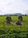
  82. coflein NPRN: not yet identified. GGAT PRN: 1072. Cadw SAM: RD004: The Four Stones
  83. coflein NPRN: not yet identified. GGAT PRN not yet identified. Cadw SAM: RD048: Two Round Barrows NE of Harpton Court
  84. coflein NPRN: not yet identified. GGAT PRN not yet identified. Cadw SAM: RD151: Worsell Wood cairn cemetery
  85. coflein NPRN: not yet identified. GGAT PRN not yet identified. Cadw SAM: RD180: Bailey Bedw Ring Cairn
  86. coflein NPRN: not yet identified. GGAT PRN not yet identified. Cadw SAM: RD245: Begwns round cairn
  87. coflein NPRN: not yet identified. GGAT PRN not yet identified. Cadw SAM: RD244: Begwns standing stone
  88. coflein NPRN: not yet identified. GGAT PRN not yet identified. Cadw SAM: RD217: Blaenhenllan round cairn
  89. coflein NPRN: not yet identified. GGAT PRN not yet identified. Cadw SAM: RD144: Lane Farm Round Barrow
  90. coflein NPRN: not yet identified. GGAT PRN not yet identified. Cadw SAM: RD065: Twyn y Garth Round Barrows
  91. coflein NPRN: not yet identified. GGAT PRN not yet identified. Cadw SAM: RD156: Cwmbrith Round Cairn
  92. coflein NPRN: not yet identified. GGAT PRN not yet identified. Cadw SAM: RD238: Ffrwd standing stone
  93. coflein NPRN: not yet identified. GGAT PRN not yet identified. Cadw SAM: RD167: Pawl Hir Ring Cairn
  94. coflein NPRN: not yet identified. GGAT PRN not yet identified. Cadw SAM: RD207: Carn Nant-y-ffald cairn
  95. coflein NPRN: not yet identified. GGAT PRN not yet identified. Cadw SAM: RD206: Carn Wen cairn
  96. coflein NPRN: not yet identified. GGAT PRN not yet identified. Cadw SAM: RD208: Carn y Groes cairn
  97. coflein NPRN: not yet identified. GGAT PRN not yet identified. Cadw SAM: RD200: Carreg Bica Round Cairn
  98. coflein NPRN: not yet identified. GGAT PRN not yet identified. Cadw SAM: RD198: Cefn Llanerchi Standing Stones
  99. coflein NPRN: not yet identified. GGAT PRN not yet identified. Cadw SAM: RD214: Cefn Troedrhiw-drain cist
  100. coflein NPRN: not yet identified. GGAT PRN not yet identified. Cadw SAM: RD210: Cistfaen barrows
  101. coflein NPRN: not yet identified. GGAT PRN not yet identified. Cadw SAM: RD209: Cistfaen cairns
  102. coflein NPRN: not yet identified. GGAT PRN not yet identified. Cadw SAM: RD212: Clap yr Arian cairn
  103. coflein NPRN: not yet identified. GGAT PRN not yet identified. Cadw SAM: RD216: Esgair Beddau cairns
  104. coflein NPRN: not yet identified. GGAT PRN not yet identified. Cadw SAM: RD201: Glog Fawr Platform Cairn
  105. coflein NPRN: not yet identified. GGAT PRN not yet identified. Cadw SAM: RD215: Nant Cletwr barrow
  106. coflein NPRN: not yet identified. GGAT PRN not yet identified. Cadw SAM: RD196: Nant Gwynllyn Standing stone
  107. coflein NPRN: not yet identified. GGAT PRN not yet identified. Cadw SAM: RD211: Nant y Llyn cist
  108. coflein NPRN: not yet identified. GGAT PRN not yet identified. Cadw SAM: RD197: Nant y Llyn Stone Row
  109. coflein NPRN: not yet identified. GGAT PRN not yet identified. Cadw SAM: RD194: Rhos y Gelynnen Ring Cairn
  110. coflein NPRN: not yet identified. GGAT PRN not yet identified. Cadw SAM: RD195: Rhos y Gelynnen Stone Row
  111. coflein NPRN: not yet identified. GGAT PRN not yet identified. Cadw SAM: RD213: Y Glog Fawr cairn
  112. coflein NPRN: not yet identified. GGAT PRN not yet identified. Cadw SAM: RD042: Bronze Age round barrow NW of Glan-marteg
  113. coflein NPRN: not yet identified. GGAT PRN not yet identified. Cadw SAM: RD192: Bronze Age tumulus north of Beili Haulwen
  114. coflein NPRN: not yet identified. GGAT PRN not yet identified. Cadw SAM: RD115: Cnych Round Barrow
  115. coflein NPRN: not yet identified. GGAT PRN not yet identified. Cadw SAM: RD078: Creggin Round Barrow
  116. coflein NPRN: not yet identified. GGAT PRN not yet identified. Cadw SAM: RD040: Crugyn Tumulus
  117. coflein NPRN: not yet identified. GGAT PRN not yet identified. Cadw SAM: RD119: Cwm y Saeson Standing Stone
  118. coflein NPRN: not yet identified. GGAT PRN not yet identified. Cadw SAM: RD204: Pont Marteg, cairn circle to E of
  119. coflein NPRN: not yet identified. GGAT PRN not yet identified. Cadw SAM: RD041: Round Barrow 400m NNW of Beili Hwlyn
  120. coflein NPRN: not yet identified. GGAT PRN not yet identified. Cadw SAM: RD070: Standing Stone & Round Barrow SE of Henriw
  121. coflein NPRN: not yet identified. GGAT PRN not yet identified. Cadw SAM: RD107: Llethrau Camp
  122. coflein NPRN: not yet identified. GGAT PRN not yet identified. Cadw SAM: RD120: Tyn'n-y-Cwm Camp
  123. coflein NPRN: not yet identified. GGAT PRN not yet identified. Cadw SAM: RD149: Castle Bank Hillfort
  124. coflein NPRN: not yet identified. GGAT PRN not yet identified. Cadw SAM: RD123: Cwm Berwyn Camp
  125. coflein NPRN: not yet identified. GGAT PRN not yet identified. Cadw SAM: RD112: Graig Camp
  126. coflein NPRN: not yet identified. GGAT PRN not yet identified. Cadw SAM: RD237: The Gaer hillfort
  127. coflein NPRN: not yet identified. GGAT PRN not yet identified. Cadw SAM: RD130: Wern Camp
  128. coflein NPRN: not yet identified. GGAT PRN not yet identified. Cadw SAM: RD038: Castell Tinboeth
  129. coflein NPRN: not yet identified. GGAT PRN not yet identified. Cadw SAM: RD102: Castell y Blaidd
  130. coflein NPRN: 306169. CPAT PRN: 1107. Cadw SAM: RD094: Camp SW of Castell Cwm Aran
  131. coflein NPRN: not yet identified. GGAT PRN not yet identified. Cadw SAM: RD093: Camp W of Cwm Cefn y Gaer
  132. coflein NPRN: not yet identified. GGAT PRN not yet identified. Cadw SAM: RD011: Cwm Cefn y Gaer
  133. coflein NPRN: not yet identified. GGAT PRN not yet identified. Cadw SAM: RD031: Carreg-Wiber Bank Earthwork
  134. coflein NPRN: not yet identified. GGAT PRN not yet identified. Cadw SAM: RD014: Caer Einon Camp
  135. coflein NPRN: not yet identified. GGAT PRN not yet identified. Cadw SAM: RD098: Glog Camp
  136. coflein NPRN: not yet identified. GGAT PRN not yet identified. Cadw SAM: RD265: Water-Break-its-Neck Promontory Fort
  137. coflein NPRN: not yet identified. GGAT PRN not yet identified. Cadw SAM: RD013: Burfa Camp
  138. coflein NPRN: not yet identified. GGAT PRN not yet identified. Cadw SAM: RD062: Castle Ring
  139. coflein NPRN: not yet identified. GGAT PRN not yet identified. Cadw SAM: RD247: Hindwell Palisaded Enclosure
  140. coflein NPRN: not yet identified. GGAT PRN not yet identified. Cadw SAM: RD262: Coed-swydd Enclosure
  141. coflein NPRN: not yet identified. GGAT PRN not yet identified. Cadw SAM: RD264: Llandegley Rocks Hillfort
This article is issued from Wikipedia - version of the 11/28/2016. The text is available under the Creative Commons Attribution/Share Alike but additional terms may apply for the media files.