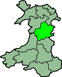
Montgomeryshire
| Montgomeryshire Welsh: Sir Drefaldwyn | |
|---|---|
 | |
 Ancient extent of Montgomeryshire | |
| Area | |
| • 1831 | 483,323 acres (1,955.94 km2) |
| • 2011 | 537,000 acres (2,170 km2) |
| Population | |
| • 1831 | 66,482[1] |
| • 2011 | 63,779 |
| Density | |
| • 1831 | 0.1/acre |
| History | |
| • Succeeded by | Powys |
| Chapman code | MGY |
| Government |
Montgomeryshire County Council (1889–1974) |
| • HQ | Montgomery |
Montgomeryshire, also known as Maldwyn (Welsh: Sir Drefaldwyn meaning "the Shire of Baldwin's town") is one of thirteen historic counties and a former administrative county of Wales. It is named after its county town, Montgomery, which in turn is named after one of William the Conqueror's main counsellors, Roger de Montgomerie, who was the 1st Earl of Shrewsbury.
Montgomeryshire today constitutes the northern part of the principal area of Powys. The population of Montgomeryshire was 63,779 according to the 2011 census,[2] with a low population density of 29 people per square km. The current area is 2,174 square km (839 square miles).
The largest town is Newtown, followed by Welshpool and Llanidloes.
History
The Treaty of Montgomery was signed in Montgomeryshire on 29 September 1267.
With the introduction of the Laws in Wales Acts 1535–1542 the marcher lordships were incorporated into the new counties of Denbighshire and Montgomeryshire. In terms of historic counties, Montgomeryshire is bounded to the north by Denbighshire, to the east and south east by Shropshire (an English county), to the south by Radnorshire, to the south west by Cardiganshire and to the west and north west by Merionethshire.
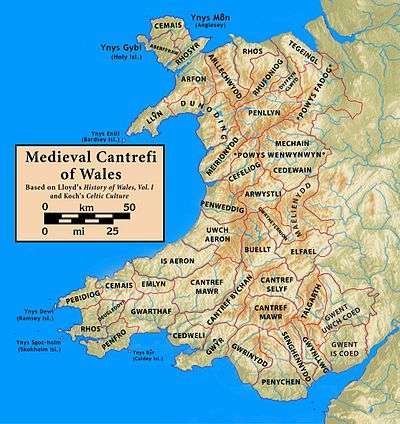
Montgomeryshire was formed from the cantrefi of:[3]
- Y Fyrnwy (commotes of Mochnant Uwch Rhaeadr, Mechain Is Coed and Llanerch Hudol)
- Llyswynaf (commotes of Caereinion and Mechain Uwch Coed)
- Maelienydd (part) (commote of Ceri at the extreme north of the cantref)
- Ystlyg (commotes of Deuddwr, Ystrad Marchell and Y Gorddwr Isaf)
- Cedewain (commotes of Cynan, Cyfeiliog and Mawddwy)
- Arwystli (commotes of Arwystli Is Coed and Arwystli Uwch Coed)
Montgomeryshire consists of a significant proportion of the medieval kingdom of Powys Wenwynwyn.
Montgomeryshire was the birthplace of Welsh Catholic martyr Saint Richard Gwyn (in 1537).
Local government
see also: Townships in Montgomeryshire.
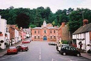
From 1889 to 1974 the county became an administrative county with a county council. Montgomery, the traditional county town, held the assizes and became the meeting place of the new County Council.[4] However, the administration continued to be based at Welshpool,[5] which prior to the reforms had been regarded as the county town.[6]
Local government reforms in 1974 combined the administrative areas of Montgomeryshire, Radnorshire and Breconshire together to form a new administrative Powys county. Montgomeryshire became a district of Powys, with its administrative headquarters in Newtown (and not Montgomery). Further local government reform in 1996 abolished district councils in Wales, making Powys a unitary authority. The Montgomeryshire area continues to have an administrative/political function as one of the three committee areas used by Powys Council, along with the other two historic counties (Radnorshire and Breconshire). These three areas are often referred to by the county council as "shires".
The few communities that were added to northern Powys in 1996 (which come within the historic boundaries of Denbighshire) now form part of the modern-day Montgomeryshire area.
Electoral representation
Montgomeryshire is a UK Parliament constituency and a Welsh Assembly constituency.
Geography
The shire is almost wholly mountainous, although there are some fertile valleys in the east. The highest point is Cadair Berwyn at 832 metres (2,730 ft). Its main rivers are the River Severn (which flows east into Shropshire) and the River Dyfi (which flows west into the Irish Sea). Lake Vyrnwy is a reservoir supplying Liverpool.
The main towns are Machynlleth, Llanidloes, Montgomery, Newtown and Welshpool. The main industries are agriculture (mainly hill farming) and tourism, though there is also some forestry and light manufacturing. The population density is highest near the border with England and along the Severn valley. The county is closely linked to Shropshire, with many essential services for Montgomeryshire residents being located in the more densely populated town of Shrewsbury, such as acute health services at the Royal Shrewsbury Hospital.
The county flower of Montgomeryshire is Spergula arvensis (also called "corn spurrey"). The shire forms a vice-county for wildlife recording.
Transport
Montgomeryshire is crossed from East to West by the Cambrian Line, a mainline passenger railway which runs between Shrewsbury and Aberystwyth with stations at Welshpool, Newtown, Caersws and Machynlleth. As of 2015 services are provided by Arriva Trains Wales.
Places of special interest
- Bryntail lead mine buildings near Llanidloes
- Centre for Alternative Technology at Llwyngwern near Machynlleth
- The Museum of Modern Art, Wales (MOMA) in Machynlleth
- Dolforwyn Castle near Abermule
- Montgomery Castle in Montgomery
- The Old Bell Museum in Montgomery
- Powis Castle near Welshpool
- The Robert Owen Museum in Newtown
- Trefeglwys Tumuli
- Mathrafal — the seat of the Welsh kings and princes of Powys
- Meifod
- Offa's Dyke
See also
- Townships in Montgomeryshire
- Local government in Wales
- History of Wales
- List of Lord Lieutenants of Montgomeryshire
- List of High Sheriffs of Montgomeryshire
References
- ↑ Vision of Britain – 1831 Census
- ↑ http://www.powys-i.org.uk/documents/en/powys_i_stats/Census%202011/Key%20Statistics/Shires/KS_M.pdf
- ↑ Cathrall, William (1828). The History of North Wales Volume II. Manchester. p. 290.
- ↑ Wynford Vaughan-Thomas and Alun Llewelyn, The Shell Guide to Wales (Michael Joseph, London, 1974) p. 339
- ↑ Vaughan-Thomas and Llewelyn, p. 339
- ↑ National Gazetteer of Wales, 1868.
Coordinates: 52°35′N 3°30′W / 52.583°N 3.500°W