| Name |
Address |
Municipality |
PC |
Coordinates |
IDF |
IDP |
IDM |
 |
Image |
|---|
| Axe Factory |
Prince William Street |
St. Stephen |
E3L |
45°11′31″N 67°15′34″W / 45.192°N 67.2594°W / 45.192; -67.2594 (Axe Factory) |
|
|
10614 |
|
 |
| The Barn |
1199 Route 776 |
Grand Manan |
|
44°41′06″N 66°46′17″W / 44.6849°N 66.7715°W / 44.6849; -66.7715 (The Barn) |
|
|
16162 |
|
|
| David Bartlett Block |
17 King Street |
St. Stephen |
E3L |
45°11′36″N 67°16′32″W / 45.1932°N 67.2755°W / 45.1932; -67.2755 (David Bartlett Block) |
|
|
10723 |
|
|
| Blair House |
38 Prince William Street |
St. Stephen |
E3L |
45°11′37″N 67°16′15″W / 45.1937°N 67.2707°W / 45.1937; -67.2707 (Blair House) |
|
|
8736 |
|
|
| John Boynton House |
348 Dock Road |
Grand Manan |
|
44°43′48″N 66°46′42″W / 44.7299°N 66.7783°W / 44.7299; -66.7783 (John Boynton House) |
|
|
16503 |
|
|
| Bridge Superintendent's House |
21 South Street |
St. George |
E5C |
45°07′37″N 66°49′38″W / 45.127°N 66.8272°W / 45.127; -66.8272 (Bridge Superintendent's House) |
|
|
10645 |
|
|
| Caswell House |
456 Milltown Blvd. |
St. Stephen |
E3L |
45°10′21″N 67°17′47″W / 45.1726°N 67.2965°W / 45.1726; -67.2965 (Caswell House) |
|
|
8451 |
|
|
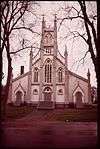
| Christ Church Anglican Church |
30 Prince William Street |
St. Stephen |
E3L |
45°11′38″N 67°16′19″W / 45.1939°N 67.2719°W / 45.1939; -67.2719 (Christ Church Anglican Church) |
|
2580 |
|
|
|
| Church of Ascension |
6 Cemetery Lane |
Grand Manan |
|
44°45′58″N 66°45′28″W / 44.7662°N 66.7579°W / 44.7662; -66.7579 (Church of Ascension) |
|
|
15785 |
|
|
| Dark Harbour Pond |
Dark Harbour Road |
Grand Manan |
|
44°44′48″N 66°50′18″W / 44.7467°N 66.8383°W / 44.7467; -66.8383 (Dark Harbour Pond) |
|
|
15789 |
|
 |
| Deep Cove School |
1141 Route 776 |
Grand Manan |
|
44°41′09″N 66°45′51″W / 44.6858°N 66.7643°W / 44.6858; -66.7643 (Deep Cove School) |
|
|
16331 |
|
|
| DeWolfe House |
64 Union Street |
St. Stephen |
E3L |
45°11′40″N 67°16′58″W / 45.1944°N 67.2829°W / 45.1944; -67.2829 (DeWolfe House) |
|
|
7630 |
|
|
| Dinsmore Hardware Building |
63 King Street |
St. Stephen |
E3L |
45°11′40″N 67°16′30″W / 45.1945°N 67.2751°W / 45.1945; -67.2751 (Dinsmore Hardware Building) |
|
|
10710 |
|
|
| Dover Hill Park |
270 Milltown Blvd. |
St. Stephen |
E3L |
45°11′26″N 67°17′14″W / 45.1906°N 67.2871°W / 45.1906; -67.2871 (Dover Hill Park) |
|
|
7693 |
|
|
| Pierre Dugua de Mons Habitation |
Route 127 |
Bayside |
E3L |
45°07′56″N 67°07′00″W / 45.1322°N 67.1168°W / 45.1322; -67.1168 (Pierre Dugua de Mons Habitation) |
|
6636 |
|
|
 |
| Dyas House |
40 Union Street |
St. Stephen |
E3L |
45°11′39″N 67°16′47″W / 45.1943°N 67.2798°W / 45.1943; -67.2798 (Dyas House) |
|
|
7643 |
|
|
| Eaton Building |
457 Milltown Blvd. |
St. Stephen |
E3L |
45°10′24″N 67°17′50″W / 45.1732°N 67.2971°W / 45.1732; -67.2971 (Eaton Building) |
|
|
10726 |
|
|
| Henry Eaton House |
13 Murchie Avenue |
St. Stephen |
E3L |
45°10′17″N 67°17′45″W / 45.1715°N 67.2958°W / 45.1715; -67.2958 (Henry Eaton House) |
|
|
8959 |
|
|
| Elim Lodge |
477 Milltown Blvd. |
St. Stephen |
E3L |
45°10′19″N 67°17′51″W / 45.1719°N 67.2974°W / 45.1719; -67.2974 (Elim Lodge) |
|
|
7702 |
|
|
| Ensor House |
15 Marks Street |
St. Stephen |
E3L |
45°11′37″N 67°16′42″W / 45.1936°N 67.2784°W / 45.1936; -67.2784 (Ensor House) |
|
|
9016 |
|
|
| First Community Cemetery |
28 Main Street |
St. George |
E5C |
45°07′49″N 66°49′20″W / 45.1302°N 66.8223°W / 45.1302; -66.8223 (First Community Cemetery) |
|
|
10678 |
|
|
| Former Calais-St. Stephen Street Railway Site |
Milltown Boulevard, West Street, Scoodic Street, King Street, Prince William Street |
St. Stephen |
|
45°10′14″N 67°17′50″W / 45.1705°N 67.2972°W / 45.1705; -67.2972 (Former Calais-St. Stephen Street Railway Site) |
|
|
16274 |
|
|
| Former Canadian Pacific Railway Station |
3 King Street |
St. Stephen |
E3L |
45°11′33″N 67°16′31″W / 45.1926°N 67.2754°W / 45.1926; -67.2754 (Former Canadian Pacific Railway Station) |
|
|
9954 |
|
 |
| Former Lightkeeper's Residence |
|
Grand Manan |
|
44°30′37″N 66°46′53″W / 44.5103°N 66.7814°W / 44.5103; -66.7814 (Former Lightkeeper's Residence) |
7874 |
|
|
|
|
| Former Site of the Milne-Coutts & Co. Granite Shed |
8 South Street |
St. George |
E5C |
45°07′39″N 66°49′33″W / 45.1274°N 66.8259°W / 45.1274; -66.8259 (Former Site of the Milne-Coutts & Co. Granite Shed) |
|
|
10644 |
|
|
| Fort Hill Cannons |
4 New Street |
St. George |
E5C |
45°07′47″N 66°49′21″W / 45.1297°N 66.8224°W / 45.1297; -66.8224 (Fort Hill Cannons) |
|
|
10630 |
|
|
| Frink House |
18 Union St. |
St. Stephen |
E3L |
45°11′39″N 67°16′38″W / 45.1942°N 67.2771°W / 45.1942; -67.2771 (Frink House) |
|
|
7649 |
|
|
| Senator Gillmor House |
8 Main Street |
St. George |
E5C |
45°07′47″N 66°49′26″W / 45.1296°N 66.824°W / 45.1296; -66.824 (Senator Gillmor House) |
|
|
8979 |
|
|
| Granville Park |
Prince William Street |
St. Stephen |
E3L |
45°11′33″N 67°16′03″W / 45.1926°N 67.2674°W / 45.1926; -67.2674 (Granville Park) |
|
|
8441 |
|
|
| Guay House |
442 Milltown Blvd. |
St. Stephen |
E3L |
45°10′27″N 67°17′46″W / 45.1743°N 67.2962°W / 45.1743; -67.2962 (Guay House) |
|
|
9009 |
|
|
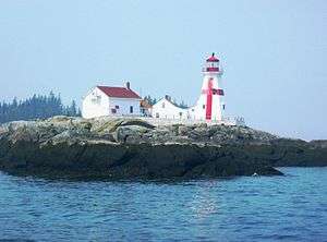
| Head Harbour Light Station |
|
Wilsons Beach |
E5E |
44°57′28″N 66°53′59″W / 44.9578°N 66.8997°W / 44.9578; -66.8997 (Head Harbour Light Station) |
|
6537 |
|
|
 |
| Hibbard House |
16 South Street |
St. George |
E5C |
45°07′38″N 66°49′35″W / 45.1271°N 66.8264°W / 45.1271; -66.8264 (Hibbard House) |
|
|
6014 |
|
|
| Hiland House |
23 Hawthorne St. |
St. Stephen |
E3L |
45°11′38″N 67°17′20″W / 45.194°N 67.2888°W / 45.194; -67.2888 (Hiland House) |
|
|
13801 |
|
|
| Hon. George Stillman Hill Home |
90 King Street |
St. Stephen |
E3L |
45°11′43″N 67°16′31″W / 45.1954°N 67.2753°W / 45.1954; -67.2753 (Hon. George Stillman Hill Home) |
|
|
7652 |
|
|
| Holy Rosary Catholic Church |
5 Rose Street |
St. Stephen |
E3L |
45°11′41″N 67°17′00″W / 45.1948°N 67.2832°W / 45.1948; -67.2832 (Holy Rosary Catholic Church) |
|
|
9940 |
|
|
| Indian Beach |
|
Grand Manan |
|
44°47′12″N 66°48′35″W / 44.7868°N 66.8096°W / 44.7868; -66.8096 (Indian Beach) |
|
|
16300 |
|
|
| James Lawson House |
146 Route 776 |
Grand Manan |
|
44°45′56″N 66°45′40″W / 44.7656°N 66.761°W / 44.7656; -66.761 (James Lawson House) |
|
|
16390 |
|
|
| Lonicera Hall |
28 Union Street |
St. Stephen |
E3L |
45°11′39″N 67°16′41″W / 45.1942°N 67.278°W / 45.1942; -67.278 (Lonicera Hall) |
|
|
7663 |
|
|
| Loyalist Burial Ground |
King Street |
St. Stephen |
E3L |
45°11′47″N 67°16′27″W / 45.1965°N 67.2743°W / 45.1965; -67.2743 (Loyalist Burial Ground) |
|
|
8763 |
|
|
| Loyalist Landing |
Chocolate Park, Milltown Blvd. |
St. Stephen |
E3L |
45°11′32″N 67°16′42″W / 45.1923°N 67.2782°W / 45.1923; -67.2782 (Loyalist Landing) |
|
|
8353 |
|
|
| Marathon Inn |
19 Marathon Lane |
Grand Manan |
|
44°45′57″N 66°44′56″W / 44.7659°N 66.749°W / 44.7659; -66.749 (Marathon Inn) |
|
|
16393 |
|
|
| Col. Nehemiah Marks Home |
39 Prince William Street |
St. Stephen |
E3L |
45°11′35″N 67°16′13″W / 45.1931°N 67.2703°W / 45.1931; -67.2703 (Col. Nehemiah Marks Home) |
|
|
8733 |
|
|
| McAllister Building |
36 Milltown Blvd. |
St. Stephen |
E3L |
45°11′33″N 67°16′39″W / 45.1925°N 67.2774°W / 45.1925; -67.2774 (McAllister Building) |
|
|
9001 |
|
|
| McConkey House |
17 Union Street |
St. Stephen |
E3L |
45°11′41″N 67°16′38″W / 45.1946°N 67.2772°W / 45.1946; -67.2772 (McConkey House) |
|
|
8951 |
|
|
| Henry McLaughlin House |
2232 Route 776 |
Grand Manan |
|
44°37′30″N 66°51′41″W / 44.6249°N 66.8615°W / 44.6249; -66.8615 (Henry McLaughlin House) |
|
|
16403 |
|
|
| Milltown United Church |
345 Milltown Boulevard |
St. Stephen |
E3L |
45°10′23″N 67°17′47″W / 45.1731°N 67.2964°W / 45.1731; -67.2964 (Milltown United Church) |
|
2306 |
|
|
|
| John Warren Moore Home |
13 Union Street |
St. Stephen |
E3L |
45°11′41″N 67°16′36″W / 45.1946°N 67.2766°W / 45.1946; -67.2766 (John Warren Moore Home) |
|
5737 |
13075 |
|
|
| Theodore Moore House |
75 Boundary Street |
St. Stephen |
E3L |
45°11′32″N 67°17′54″W / 45.1923°N 67.2984°W / 45.1923; -67.2984 (Theodore Moore House) |
|
|
8956 |
|
|
| James Simpson Murchie House |
443 Milltown Blvd. |
St. Stephen |
E3L |
45°10′28″N 67°17′48″W / 45.1744°N 67.2968°W / 45.1744; -67.2968 (James Simpson Murchie House) |
|
|
7671 |
|
|
| Napa Auto Parts Building |
16 King Street |
St. Stephen |
E3L |
45°11′36″N 67°16′34″W / 45.1932°N 67.276°W / 45.1932; -67.276 (Napa Auto Parts Building) |
|
|
10724 |
|
|
| Isaac Newton House |
1120 Route 776 |
Grand Manan |
|
44°41′16″N 66°45′44″W / 44.6878°N 66.7621°W / 44.6878; -66.7621 (Isaac Newton House) |
|
|
15834 |
|
|
| Nicholson House |
27 Hawthorne Street |
St. Stephen |
E3L |
45°11′39″N 67°17′20″W / 45.1941°N 67.289°W / 45.1941; -67.289 (Nicholson House) |
|
|
9018 |
|
|
| North Head School |
130 Route 776 |
Grand Manan |
|
44°45′57″N 66°45′32″W / 44.7657°N 66.7589°W / 44.7657; -66.7589 (North Head School) |
|
|
16302 |
|
|
| Old Ganong Candy Factory |
73 Milltown Blvd. |
St. Stephen |
E3L |
45°11′34″N 67°16′46″W / 45.1927°N 67.2794°W / 45.1927; -67.2794 (Old Ganong Candy Factory) |
|
|
8449 |
|
 |
| Old North Head Cemetery |
6 Cemetery Lane |
Grand Manan |
|
44°45′58″N 66°45′26″W / 44.7661°N 66.7572°W / 44.7661; -66.7572 (Old North Head Cemetery) |
|
|
15828 |
|
|
| Old Pioneer Cemetery |
Route 776 |
Grand Manan |
|
44°41′02″N 66°46′34″W / 44.6838°N 66.7761°W / 44.6838; -66.7761 (Old Pioneer Cemetery) |
|
|
15803 |
|
|
| Old Pioneer Cemetery Extension |
Foster Hill Road, between civic numbers 9 and 39 |
Grand Manan |
|
44°41′05″N 66°46′40″W / 44.6847°N 66.7779°W / 44.6847; -66.7779 (Old Pioneer Cemetery Extension) |
|
|
15831 |
|
|
| Old Power House |
1071 Route 776 |
Grand Manan |
|
44°41′21″N 66°45′27″W / 44.6893°N 66.7575°W / 44.6893; -66.7575 (Old Power House) |
|
|
15941 |
|
|
| Old Seal Cove Cemetery |
Route 776 |
Grand Manan |
|
44°38′44″N 66°50′59″W / 44.6455°N 66.8496°W / 44.6455; -66.8496 (Old Seal Cove Cemetery) |
|
|
15826 |
|
|
| Parsons Printing Building |
8 King Street |
St. Stephen |
E3L |
45°11′34″N 67°16′34″W / 45.1929°N 67.276°W / 45.1929; -67.276 (Parsons Printing Building) |
|
|
10616 |
|
|
| Polkinhorn House |
849 Route 776 |
Grand Manan |
|
44°42′22″N 66°44′36″W / 44.7062°N 66.7433°W / 44.7062; -66.7433 (Polkinhorn House) |
|
|
16386 |
|
|
| Potter Cottage |
6 Old Airport Road |
Grand Manan |
|
44°45′50″N 66°44′29″W / 44.764°N 66.7415°W / 44.764; -66.7415 (Potter Cottage) |
|
|
16502 |
|
|
| Presbyterian Kirk |
180 Brunswick Street |
St. George |
E5C |
45°07′46″N 66°49′36″W / 45.1295°N 66.8267°W / 45.1295; -66.8267 (Presbyterian Kirk) |
|
|
10639 |
|
|
| Richardson and Son Boat Building |
Richardson Road |
West Isles Parish |
E5V |
44°59′55″N 66°56′51″W / 44.9985°N 66.9474°W / 44.9985; -66.9474 (Richardson and Son Boat Building) |
|
8685 |
|
|
|
| John B. Robinson House |
53 Prince William Street |
St. Stephen |
E3L |
45°11′34″N 67°16′05″W / 45.1929°N 67.2681°W / 45.1929; -67.2681 (John B. Robinson House) |
|
|
7661 |
|
|
| St. Croix Cotton Mill Site |
5 Mill Lane |
St. Stephen |
E3L |
45°10′33″N 67°17′41″W / 45.1758°N 67.2946°W / 45.1758; -67.2946 (St. Croix Cotton Mill Site) |
|
|
10612 |
|
|
| St. George Gorge at First Falls |
Adjacent to 24 Mill Road |
St. George |
E5C |
45°07′45″N 66°49′43″W / 45.1291°N 66.8287°W / 45.1291; -66.8287 (St. George Gorge at First Falls) |
|
|
6732 |
|
.JPG) |
| St. George Government of Canada Building |
23 Portage Street |
St. George |
E5C |
45°07′46″N 66°49′33″W / 45.1294°N 66.8257°W / 45.1294; -66.8257 (St. George Government of Canada Building) |
|
10763 |
|
|
|
| St. George Rural Cemetery |
Cemetery Road |
St. George |
E5C |
45°07′45″N 66°48′50″W / 45.1291°N 66.8138°W / 45.1291; -66.8138 (St. George Rural Cemetery) |
|
|
10682 |
|
|
| St. George Superior School Bell |
1 School Street |
St. George |
E5C |
45°07′46″N 66°49′19″W / 45.1294°N 66.822°W / 45.1294; -66.822 (St. George Superior School Bell) |
|
|
8966 |
|
|
| St. Paul's Anglican Church |
3 Ingalls Head Road |
Grand Manan |
|
44°41′01″N 66°46′27″W / 44.6837°N 66.7743°W / 44.6837; -66.7743 (St. Paul's Anglican Church) |
|
|
15786 |
|
|
| St. Stephen Post Office National Historic Site of Canada |
34 Milltown Boulevard |
St. Stephen |
046 |
45°11′33″N 67°16′38″W / 45.1924°N 67.2773°W / 45.1924; -67.2773 (St. Stephen Post Office National Historic Site of Canada) |
12544 |
|
|
|
|
| St. Stephen's Roman Catholic Church |
407 Milltown Blvd. |
St. Stephen |
E3L |
45°10′42″N 67°17′43″W / 45.1784°N 67.2952°W / 45.1784; -67.2952 (St. Stephen's Roman Catholic Church) |
|
|
8338 |
|
 |
| St. Stephen Rural Cemetery |
Hanson Road / Hayman Avenue |
St. Stephen |
E3L |
45°12′03″N 67°18′06″W / 45.2009°N 67.3018°W / 45.2009; -67.3018 (St. Stephen Rural Cemetery) |
|
|
8762 |
|
|
| St. Stephen's University |
8 Main Street |
St. Stephen |
E3L |
45°11′35″N 67°16′55″W / 45.193°N 67.2819°W / 45.193; -67.2819 (St. Stephen's University) |
|
|
7678 |
|
|
| St. Timothy's Hall |
31 Marks Street |
St. Stephen |
E3L |
45°11′43″N 67°16′41″W / 45.1953°N 67.278°W / 45.1953; -67.278 (St. Timothy's Hall) |
|
|
9011 |
|
|
| Salmon Falls Senior Citizens Centre |
450 Milltown Blvd. |
St. Stephen |
E3L |
45°10′24″N 67°17′47″W / 45.1734°N 67.2964°W / 45.1734; -67.2964 (Salmon Falls Senior Citizens Centre) |
|
|
13077 |
|
|
| Salmon Fish Ladder |
St. George Gorge at First Falls |
St. George |
E5C |
45°07′43″N 66°49′36″W / 45.1285°N 66.8267°W / 45.1285; -66.8267 (Salmon Fish Ladder) |
|
|
8973 |
|
|
| Seal Cove School |
1930 Route 776 |
Grand Manan |
|
44°38′59″N 66°50′45″W / 44.6497°N 66.8458°W / 44.6497; -66.8458 (Seal Cove School) |
|
|
17401 |
|
|
| Seal Cove Smoked Herring Stands National Historic Site of Canada |
Seal Cove |
Grand Manan |
E5G |
44°39′N 66°51′W / 44.65°N 66.85°W / 44.65; -66.85 (Seal Cove Smoked Herring Stands National Historic Site of Canada) |
2343 |
|
|
|
 |
| J & C Short Shipbuilding Site |
12 Denny Street |
St. Stephen |
E3L |
45°11′24″N 67°15′44″W / 45.1899°N 67.2623°W / 45.1899; -67.2623 (J & C Short Shipbuilding Site) |
|
|
8999 |
|
|
| Sinclair House |
41 Riverside Drive |
St. Stephen |
E3L |
45°10′16″N 67°17′52″W / 45.1712°N 67.2977°W / 45.1712; -67.2977 (Sinclair House) |
|
|
12777 |
|
|
| Site of Peter Clinch Landing |
1 Clinch Street |
St. George |
E5C |
45°07′41″N 66°49′23″W / 45.128°N 66.823°W / 45.128; -66.823 (Site of Peter Clinch Landing) |
|
|
6009 |
|
|
| Swallowtail Lightstation[1] |
50 Light House Road |
Grand Manan |
|
44°45′51″N 66°44′01″W / 44.7641°N 66.7336°W / 44.7641; -66.7336 (Swallowtail Lightstation[2]) |
|
|
16105 |
|
|
| Todd House |
75 Pleasant St. |
St. Stephen |
E3L |
45°10′25″N 67°18′05″W / 45.1737°N 67.3013°W / 45.1737; -67.3013 (Todd House) |
|
|
7655 |
|
|
| Todd Mansion |
45 Union Street |
St. Stephen |
E3L |
45°11′41″N 67°16′52″W / 45.1948°N 67.2811°W / 45.1948; -67.2811 (Todd Mansion) |
|
|
8357 |
|
|
| Town Pump and Water Trough |
23 Portage Street |
St. George |
E5C |
45°07′47″N 66°49′31″W / 45.1296°N 66.8254°W / 45.1296; -66.8254 (Town Pump and Water Trough) |
|
|
6005 |
|
|
| Vaughan House |
72 Union Street |
St. Stephen |
E3L |
45°11′40″N 67°17′03″W / 45.1944°N 67.2841°W / 45.1944; -67.2841 (Vaughan House) |
|
|
8764 |
|
|
| War Memorial Cenotaph |
165 Milltown Blvd. |
St. Stephen |
E3L |
45°11′33″N 67°16′56″W / 45.1926°N 67.2822°W / 45.1926; -67.2822 (War Memorial Cenotaph) |
|
|
8952 |
|
|
| Whale Cove Cottages |
26 Whale Cottage Road |
Grand Manan |
|
44°46′30″N 66°45′54″W / 44.7751°N 66.7651°W / 44.7751; -66.7651 (Whale Cove Cottages) |
|
|
16387 |
|
|