| Name |
Address |
Municipality |
PC |
Coordinates |
IDF |
IDP |
IDM |
 |
Image |
|---|
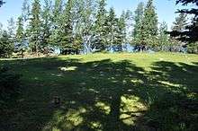
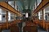
| Ashbourne Longhouse |
|
Twillingate |
A0G |
49°39′19″N 54°45′40″W / 49.6554°N 54.761°W / 49.6554; -54.761 (Ashbourne Longhouse) |
|
2308 |
16265 |
|

More images |
| Ashbourne Office Registered Heritage Structure |
|
Twillingate |
A0G |
49°39′19″N 54°45′40″W / 49.6553°N 54.761°W / 49.6553; -54.761 (Ashbourne Office Registered Heritage Structure) |
|
12899 |
|
|
 |
| Ashbourne Shop Registered Heritage Structure |
|
Twillingate |
A0G |
49°39′19″N 54°45′40″W / 49.6554°N 54.761°W / 49.6554; -54.761 (Ashbourne Shop Registered Heritage Structure) |
|
12900 |
|
|
|
| Bait Depot |
16 Lower Water Street |
Grand Bank |
|
47°06′02″N 55°45′00″W / 47.1005°N 55.75°W / 47.1005; -55.75 (Bait Depot) |
2008 |
|
|
|
 |
| Bank of Nova Scotia |
|
Burin |
A0E |
47°04′32″N 55°08′20″W / 47.0755°N 55.1389°W / 47.0755; -55.1389 (Bank of Nova Scotia, Burin) |
|
2016 |
|
|
|
| Alphaeus Barbour House |
|
Newtown |
A0G |
49°12′06″N 53°30′55″W / 49.2018°N 53.5154°W / 49.2018; -53.5154 (Alphaeus Barbour House) |
|
2108 |
|
|
|
| Benjamin Barbour House |
|
New-Wes-Valley |
A0G |
49°12′06″N 53°30′56″W / 49.2018°N 53.5155°W / 49.2018; -53.5155 (Benjamin Barbour House) |
|
2201 |
|
|
|
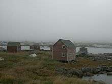
| Beaver Pond Municipal Heritage Site |
|
Harbour Breton |
A0H |
47°28′37″N 55°49′55″W / 47.477°N 55.832°W / 47.477; -55.832 (Beaver Pond Municipal Heritage Site) |
|
|
11962 |
|
|
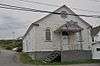
| Bethany United Church |
|
Petites |
A0M |
47°37′12″N 58°37′49″W / 47.6199°N 58.6303°W / 47.6199; -58.6303 (Bethany United Church) |
|
2318 |
|
|
|
| Bleak House Registered Heritage Structure |
|
Fogo |
A0G |
49°43′06″N 54°17′10″W / 49.7182°N 54.2861°W / 49.7182; -54.2861 (Bleak House Registered Heritage Structure) |
|
1891 |
10194 |
|
|
| Boyd's Cove Beothuk National Historic Site of Canada |
|
Boyd's Cove |
A0G |
49°27′45″N 54°37′46″W / 49.4626°N 54.6294°W / 49.4626; -54.6294 (Boyd's Cove Beothuk National Historic Site of Canada) |
10557 |
|
|
|
More images |
| Brett House and Outbuildings |
|
Joe Batt's Arm-Barr'd Islands-Shoal Bay |
A0G |
49°43′47″N 54°10′24″W / 49.7296°N 54.1733°W / 49.7296; -54.1733 (Brett House and Outbuildings) |
|
2228 |
8144 |
|
|
| John and Ann Brinson House |
|
Carmanville South |
A0G |
49°23′58″N 54°15′36″W / 49.3994°N 54.2599°W / 49.3994; -54.2599 (John and Ann Brinson House) |
|
2134 |
|
|
|
| Buffett House Registered Heritage Structure |
|
Grand Bank |
A0E |
47°06′08″N 55°45′15″W / 47.1022°N 55.7542°W / 47.1022; -55.7542 (Buffett House Registered Heritage Structure) |
|
7779 |
|
|
|
| Cape Chapeau Rouge Municipal Heritage Site |
|
St. Lawrence |
A0E |
46°53′26″N 55°22′31″W / 46.8905°N 55.3754°W / 46.8905; -55.3754 (Cape Chapeau Rouge Municipal Heritage Site) |
|
|
3593 |
|
|
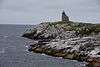
| Cape Ray Light Tower |
|
Cape Ray |
|
47°37′16″N 59°18′14″W / 47.6211°N 59.3039°W / 47.6211; -59.3039 (Cape Ray Light Tower) |
13113 |
|
|
|
 |
| Hector Carter House, Henhouse, Fishing Shed and Property Registered Heritage Structure |
|
Greenspond |
A0G |
49°04′07″N 53°34′03″W / 49.0686°N 53.5675°W / 49.0686; -53.5675 (Hector Carter House, Henhouse, Fishing Shed and Property Registered Heritage Structure) |
|
10636 |
|
|
|
| Cemetery for Priests and Religious Sisters Municipal Heritage Site |
|
St. Lawrence |
A0E |
46°55′17″N 55°22′39″W / 46.9214°N 55.3774°W / 46.9214; -55.3774 (Cemetery for Priests and Religious Sisters Municipal Heritage Site) |
|
|
5452 |
|
|
| Channel Head Lighttower |
|
Channel-Port aux Basques |
|
47°33′58″N 59°07′26″W / 47.566°N 59.1239°W / 47.566; -59.1239 (Channel Head Lighttower) |
3901 |
|
|
|

More images |
| Noah Chippett Stage/Twine Loft and Wharf Municipal Heritage Site |
|
Leading Tickles |
A0H |
49°30′04″N 55°28′05″W / 49.501°N 55.468°W / 49.501; -55.468 (Noah Chippett Stage/Twine Loft and Wharf Municipal Heritage Site) |
|
|
7308 |
|
|
| Roland Chippett Stage Municipal Heritage Building |
|
Leading Tickles |
A0H |
49°30′04″N 55°28′05″W / 49.501°N 55.468°W / 49.501; -55.468 (Roland Chippett Stage Municipal Heritage Building) |
|
|
7309 |
|
|
| Church of England Cemetery Municipal Heritage Site |
Causeway Extension |
Burnt Islands |
A0M |
47°35′57″N 58°53′25″W / 47.5992°N 58.8903°W / 47.5992; -58.8903 (Church of England Cemetery Municipal Heritage Site) |
|
|
13793 |
|
|
| Cluett House Registered Heritage Structure |
|
Belleoram |
A0H |
47°31′00″N 55°25′00″W / 47.5167°N 55.4167°W / 47.5167; -55.4167 (Cluett House Registered Heritage Structure) |
|
2089 |
|
|
|
| Connaught Hall Masonic Lodge #9 |
|
Botwood |
A0H |
49°08′36″N 55°20′28″W / 49.1434°N 55.3411°W / 49.1434; -55.3411 (Connaught Hall Masonic Lodge #9) |
|
2325 |
|
|
|
| Deadman's Cove Municipal Heritage Site |
|
Harbour Breton |
|
47°28′01″N 55°50′49″W / 47.467°N 55.847°W / 47.467; -55.847 (Deadman's Cove Municipal Heritage Site) |
|
|
15369 |
|
|
| Dwyer House |
|
Tilting |
A0G |
49°42′20″N 54°03′31″E / 49.7056°N 54.0585°E / 49.7056; 54.0585 (Dwyer House) |
|
2170 |
|
|
|
| Fidelity Lodge #5 |
|
Grand Bank |
A0E |
47°06′08″N 55°45′21″W / 47.1023°N 55.7559°W / 47.1023; -55.7559 (Fidelity Lodge #5) |
|
1893 |
7458 |
|
|
| Fishermen's Union Trading Company Cash Store Registered Heritage Structure |
|
Musgrave Harbour |
A0G |
49°26′59″N 53°56′35″W / 49.4496°N 53.9431°W / 49.4496; -53.9431 (Fishermen's Union Trading Company Cash Store Registered Heritage Structure) |
|
8145 |
|
|
|
| Fishermen's Union Trading Company Premises Registered Heritage Structure |
|
Seldom-Little Seldom |
|
49°36′36″N 54°11′06″W / 49.6099°N 54.185°W / 49.6099; -54.185 (Fishermen's Union Trading Company Premises Registered Heritage Structure) |
|
15663 |
|
|
|
| Fleur de Lys Dorset Soapstone Quarry |
|
Fleur de Lys |
A0K |
50°07′11″N 56°07′27″W / 50.1197°N 56.1241°W / 50.1197; -56.1241 (Fleur de Lys Dorset Soapstone Quarry) |
|
4127 |
|
|
|
| Fogo Courthouse and Public Building Municipal Heritage Site |
|
Fogo |
|
49°42′54″N 54°16′52″W / 49.715°N 54.281°W / 49.715; -54.281 (Fogo Courthouse and Public Building Municipal Heritage Site) |
|
|
15365 |
|
|
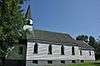
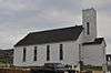
| Fogo United Church |
|
Fogo |
A0G |
49°42′53″N 54°16′56″W / 49.7148°N 54.2822°W / 49.7148; -54.2822 (Fogo United Church) |
|
2024 |
|
|
|
| Pearce Foley House Registered Heritage Structure |
|
Tilting |
A0G |
49°42′18″N 54°03′31″W / 49.705°N 54.0585°W / 49.705; -54.0585 (Pearce Foley House Registered Heritage Structure) |
|
2296 |
|
|
|
| J. B. Foote House Municipal Heritage Building |
|
Grand Bank |
A0E |
47°06′09″N 55°45′31″W / 47.1024°N 55.7586°W / 47.1024; -55.7586 (J. B. Foote House Municipal Heritage Building) |
|
|
7461 |
|
|
| Fortune Fishing Sheds Municipal Heritage Site |
|
Fortune |
A0E |
47°04′25″N 55°49′35″W / 47.0736°N 55.8264°W / 47.0736; -55.8264 (Fortune Fishing Sheds Municipal Heritage Site) |
|
|
5866 |
|
|
| Frazer Park Municipal Heritage Site |
|
Grand Bank |
A0E |
47°06′04″N 55°45′14″W / 47.101°N 55.754°W / 47.101; -55.754 (Frazer Park Municipal Heritage Site) |
|
|
7459 |
|
|
| Friar's Cove Municipal Heritage Site |
|
Harbour Breton |
|
47°27′50″N 55°47′49″W / 47.464°N 55.797°W / 47.464; -55.797 (Friar's Cove Municipal Heritage Site) |
|
|
15368 |
|
|
| Gorman/Hynes House Municipal Heritage Site |
|
Harbour Breton |
A0H |
47°28′19″N 55°49′37″W / 47.472°N 55.827°W / 47.472; -55.827 (Gorman/Hynes House Municipal Heritage Site) |
|
|
13794 |
|
|
| H.C. Grant Heritage Museum Registered Heritage Structure |
|
Springdale |
A0J |
49°29′48″N 56°04′13″W / 49.4966°N 56.0703°W / 49.4966; -56.0703 (H.C. Grant Heritage Museum Registered Heritage Structure) |
|
4017 |
5348 |
|
|
| Martin Greene House and Outbuildings |
|
Tilting |
A0G |
49°42′08″N 54°03′50″W / 49.7023°N 54.0639°W / 49.7023; -54.0639 (Martin Greene House and Outbuildings) |
|
2025 |
|
|
|
| Greenspond Courthouse |
|
Greenspond |
A0G |
49°04′07″N 53°34′05″W / 49.0686°N 53.5681°W / 49.0686; -53.5681 (Greenspond Courthouse) |
|
2074 |
|
|
|
| Gun Hill Municipal Heritage Site |
|
Harbour Breton |
A0H |
47°29′20″N 55°48′40″W / 47.489°N 55.811°W / 47.489; -55.811 (Gun Hill Municipal Heritage Site) |
|
|
11963 |
|
|
| Harbour Breton Landslide Monument Municipal Heritage Site |
|
Harbour Breton |
A0H |
47°28′44″N 55°48′22″W / 47.479°N 55.806°W / 47.479; -55.806 (Harbour Breton Landslide Monument Municipal Heritage Site) |
|
|
13240 |
|
|
| Harding House |
|
Greenspond |
A0G |
49°04′07″N 53°34′03″W / 49.0686°N 53.5675°W / 49.0686; -53.5675 (Harding House) |
|
1887 |
|
|
|
| Harmsworth Hall |
|
Grand Falls-Windsor |
A0H |
49°00′35″N 55°30′31″W / 49.0096°N 55.5085°W / 49.0096; -55.5085 (Harmsworth Hall) |
|
2560 |
|
|

More images |
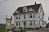
| George C. Harris House |
|
Grand Bank |
A0E |
47°06′03″N 55°45′14″W / 47.1007°N 55.754°W / 47.1007; -55.754 (George C. Harris House) |
|
2195 |
7460 |
|
|
| Hart's Cove General Cemetery Municipal Heritage Site |
|
Twillingate |
|
49°39′47″N 54°45′32″W / 49.663°N 54.759°W / 49.663; -54.759 (Hart's Cove General Cemetery Municipal Heritage Site) |
|
|
16267 |
|
 |
| Patrick Hayden Residence |
|
Petit Forte |
A0B |
47°23′43″N 54°40′06″W / 47.3954°N 54.6683°W / 47.3954; -54.6683 (Patrick Hayden Residence) |
|
5314 |
|
|
|
| Hewlett House and Grounds Municipal Heritage Site |
|
Roberts Arm |
A0J |
49°29′02″N 55°50′30″W / 49.4838°N 55.8418°W / 49.4838; -55.8418 (Hewlett House and Grounds Municipal Heritage Site) |
|
|
5966 |
|
|
| Hodge Brothers Premises Registered Heritage Structure |
|
Twillingate |
A0G |
49°39′26″N 54°46′29″W / 49.6571°N 54.7748°W / 49.6571; -54.7748 (Hodge Brothers Premises Registered Heritage Structure) |
|
5356 |
|
|
|
| Hunt's Point Municipal Heritage Site |
|
Harbour Breton |
A0H |
47°29′06″N 55°48′07″W / 47.485°N 55.802°W / 47.485; -55.802 (Hunt's Point Municipal Heritage Site) |
|
|
12909 |
|
|
| Iron Springs Mine Municipal Heritage Site |
|
St. Lawrence |
A0E |
46°59′10″N 55°25′02″W / 46.9862°N 55.4173°W / 46.9862; -55.4173 (Iron Springs Mine Municipal Heritage Site) |
|
|
3594 |
|
|
| Ephraim Jacobs House Municipal Heritage Site |
|
Twillingate |
|
49°39′47″N 54°45′36″W / 49.6631°N 54.7601°W / 49.6631; -54.7601 (Ephraim Jacobs House Municipal Heritage Site) |
|
|
16266 |
|
 |
| Kean's General Store |
|
Brookfield |
A0G |
49°08′25″N 53°34′58″W / 49.1404°N 53.5827°W / 49.1404; -53.5827 (Kean's General Store) |
|
1994 |
|
|
|
| George and Mary Lake House Municipal Heritage Site |
|
Fortune |
A0E |
47°04′27″N 55°49′40″W / 47.0743°N 55.8279°W / 47.0743; -55.8279 (George and Mary Lake House Municipal Heritage Site) |
|
|
5763 |
|
|
| Lane House |
|
Tilting |
A0G |
49°42′29″N 54°03′55″W / 49.7081°N 54.0653°W / 49.7081; -54.0653 (Lane House) |
|
2114 |
|
|
|
| Lighttower |
|
Fortune Bay |
|
47°28′24″N 55°24′20″W / 47.4732°N 55.4056°W / 47.4732; -55.4056 (Lighttower, Fortune Bay) |
3903 |
|
|
|
|
| Long Island Consumers Co-op Store Municipal Heritage Building |
|
Lushes Bight-Beaumont-Beaumont North |
A0J |
49°36′50″N 55°40′41″W / 49.614°N 55.678°W / 49.614; -55.678 (Long Island Consumers Co-op Store Municipal Heritage Building) |
|
|
7480 |
|
|
| Long Point Light Station Dwelling Registered Heritage Structure |
|
Crow Head |
A0G |
49°41′16″N 54°48′01″W / 49.6877°N 54.8002°W / 49.6877; -54.8002 (Long Point Light Station Dwelling Registered Heritage Structure) |
9625 |
6407 |
|
|
 |
| Long Point Lightstation Municipal Heritage Site |
|
Crow Head |
A0G |
49°41′16″N 54°48′01″W / 49.6878°N 54.8002°W / 49.6878; -54.8002 (Long Point Lightstation Municipal Heritage Site) |
|
|
5994 |
|
 |
| Loveridge House |
|
Twillingate |
A0G |
49°39′00″N 54°46′13″W / 49.65°N 54.7702°W / 49.65; -54.7702 (Loveridge House) |
|
2627 |
16268 |
|
|
| Lucky Strike Deckhead Municipal Heritage Structure |
|
Buchans |
A0H |
48°49′24″N 56°51′14″W / 48.8234°N 56.8539°W / 48.8234; -56.8539 (Lucky Strike Deckhead Municipal Heritage Structure) |
|
|
7310 |
|
|
| Man-of-War Brook Municipal Heritage Site |
|
Harbour Breton |
A0H |
47°28′30″N 55°48′52″W / 47.475°N 55.8144°W / 47.475; -55.8144 (Man-of-War Brook Municipal Heritage Site) |
|
|
10832 |
|
|
| Newman and Company Root Cellar Municipal Heritage Site |
|
Harbour Breton |
|
47°28′48″N 55°48′07″W / 47.48°N 55.802°W / 47.48; -55.802 (Newman and Company Root Cellar Municipal Heritage Site) |
|
|
15367 |
|
|
| Newman's Flagpole Rock Municipal Heritage Site |
|
Harbour Breton |
A0H |
47°29′N 55°48′W / 47.48°N 55.8°W / 47.48; -55.8 (Newman's Flagpole Rock Municipal Heritage Site) |
|
|
13795 |
|
|
| Old Catholic Cemetery Municipal Heritage Site |
|
Leading Tickles |
A0H |
49°29′41″N 55°27′26″W / 49.4947°N 55.4573°W / 49.4947; -55.4573 (Old Catholic Cemetery Municipal Heritage Site) |
|
|
8008 |
|
|
| Old Church of England Cemetery Municipal Heritage Site |
|
Leading Tickes |
A0H |
49°30′13″N 55°27′29″W / 49.5035°N 55.458°W / 49.5035; -55.458 (Old Church of England Cemetery Municipal Heritage Site) |
|
|
8006 |
|
|
| Old House Cove General Cemetery Municipal Heritage Site |
|
Twillingate |
|
49°38′56″N 54°46′30″W / 49.649°N 54.775°W / 49.649; -54.775 (Old House Cove General Cemetery Municipal Heritage Site) |
|
|
16269 |
|
 |
| Old Methodist Cemetery Municipal Heritage Site |
|
Leading Tickles |
A0H |
49°30′05″N 55°28′13″W / 49.5015°N 55.4703°W / 49.5015; -55.4703 (Old Methodist Cemetery Municipal Heritage Site) |
|
|
8007 |
|
|
| Old Schoolhouse Municipal Heritage Building |
|
Fogo |
A0G |
49°42′54″N 54°16′58″W / 49.715°N 54.2827°W / 49.715; -54.2827 (Old Schoolhouse Municipal Heritage Building) |
|
|
10195 |
|
|
| Pickersgill Premises Registered Heritage Structure |
|
Salvage |
A0G |
48°41′00″N 53°38′00″W / 48.6833°N 53.6333°W / 48.6833; -53.6333 (Pickersgill Premises Registered Heritage Structure) |
|
2334 |
|
|
|
| Piercey House Municipal Heritage Site |
|
Milltown-Head of Bay D'Espoir |
A0H |
47°54′54″N 55°45′03″W / 47.915°N 55.7508°W / 47.915; -55.7508 (Piercey House Municipal Heritage Site) |
|
|
13798 |
|
|
| Red Head Municipal Heritage Site |
|
Harbour Breton |
|
47°27′32″N 55°49′55″W / 47.459°N 55.832°W / 47.459; -55.832 (Red Head Municipal Heritage Site) |
|
|
15366 |
|
|
| Reddy Property Municipal Heritage Site |
|
Marystown |
A0E |
47°09′31″N 55°09′45″W / 47.1585°N 55.1625°W / 47.1585; -55.1625 (Reddy Property Municipal Heritage Site) |
|
|
5380 |
|
|
| Rocky Point Light Tower Municipal Heritage Site |
|
Harbour Breton |
A0H |
47°28′44″N 55°47′38″W / 47.479°N 55.794°W / 47.479; -55.794 (Rocky Point Light Tower Municipal Heritage Site) |
|
|
13796 |
|
|
| John Rodway Senior Residence |
|
Baine Harbour |
A0E |
47°21′37″N 54°53′19″W / 47.3603°N 54.8886°W / 47.3603; -54.8886 (John Rodway Senior Residence) |
|
2628 |
|
|
|
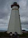
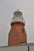
| Rose Blanche Lighthouse |
|
Rose Blanche |
A0M |
47°37′00″N 58°41′00″W / 47.6167°N 58.6833°W / 47.6167; -58.6833 (Rose Blanche Lighthouse) |
|
2095 |
|
|
More images |
| St. Andrew's Anglican Church and Cemetery Municipal Heritage Site |
|
Fogo |
A0G |
49°42′54″N 54°16′48″W / 49.715°N 54.2801°W / 49.715; -54.2801 (St. Andrew's Anglican Church and Cemetery Municipal Heritage Site) |
|
|
8143 |
|

More images |
| St. Anne's Church |
|
Little Fogo Island |
A0G |
49°48′42″N 54°07′15″W / 49.8117°N 54.1207°W / 49.8117; -54.1207 (St. Anne's Church) |
|
2092 |
|
|
More images |
| St. Bartholomew's Memorial Stone Municipal Heritage Site |
|
Harbour Breton |
A0H |
47°28′48″N 55°48′50″W / 47.48°N 55.814°W / 47.48; -55.814 (St. Bartholomew's Memorial Stone Municipal Heritage Site) |
|
|
13797 |
|
|
| St. Cecilia Roman Catholic Cemetery Municipal Heritage Site |
|
St. Lawrence |
A0E |
46°55′33″N 55°23′32″W / 46.9257°N 55.3922°W / 46.9257; -55.3922 (St. Cecilia Roman Catholic Cemetery Municipal Heritage Site) |
|
|
8581 |
|
|
| St. Gabriel's Hall Municipal Heritage Building |
|
Marystown |
A0E |
47°09′40″N 55°09′43″W / 47.1611°N 55.1619°W / 47.1611; -55.1619 (St. Gabriel's Hall Municipal Heritage Building) |
|
|
7277 |
|
|
| St. John Lodge Society of United Fishermen No. 11 Municipal Heritage Building |
|
Joe Batt's Arm-Barr'd Islands-Shoal Bay |
A0G |
49°43′31″N 54°10′44″W / 49.7253°N 54.1789°W / 49.7253; -54.1789 (St. John Lodge Society of United Fishermen No. 11 Municipal Heritage Building) |
|
|
10196 |
|
|
| St. Lawrence Centennial Soccer Field |
|
St. Lawrence |
A0E |
46°55′21″N 55°23′38″W / 46.9224°N 55.394°W / 46.9224; -55.394 (St. Lawrence Centennial Soccer Field) |
|
|
3554 |
|
|
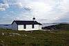
| St. Mark's Church |
|
Nippers Harbour |
A0K |
49°47′03″N 55°52′01″W / 49.7843°N 55.8669°W / 49.7843; -55.8669 (St. Mark's Church) |
|
2109 |
|
|
|
| St. Matthew's Anglican Cemetery Municipal Heritage Site |
|
St. Lawrence |
A0E |
46°55′30″N 55°23′28″W / 46.925°N 55.3911°W / 46.925; -55.3911 (St. Matthew's Anglican Cemetery Municipal Heritage Site, St. Lawrence) |
|
|
8580 |
|
|
| St. Matthew's Presbyterian Church |
|
Grand Falls-Windsor |
A2A |
48°55′52″N 55°39′34″W / 48.9312°N 55.6594°W / 48.9312; -55.6594 (St. Matthew's Presbyterian Church, Grand Falls-Windsor) |
|
|
5022 |
|
More images |
| St. Peter's Anglican Cemetery Municipal Heritage Site |
|
Twillingate |
|
49°39′17″N 54°46′42″W / 49.6547°N 54.7783°W / 49.6547; -54.7783 (St. Peter's Anglican Cemetery Municipal Heritage Site) |
|
|
16270 |
|
|
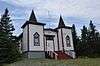
| St. Peter's Anglican Church |
|
Twillingate |
A0G |
49°39′22″N 54°46′33″W / 49.6562°N 54.7759°W / 49.6562; -54.7759 (St. Peter's Anglican Church) |
|
1902 |
|
|
More images |
| St. Peter's Lodge SUF #12, Victoria Hall, Registered Heritage Structure |
|
Twillingate |
A0G |
49°38′59″N 54°46′20″W / 49.6497°N 54.7723°W / 49.6497; -54.7723 (St. Peter's Lodge SUF #12, Victoria Hall, Registered Heritage Structure) |
|
5342 |
|
|
More images |
| South Side United Church Municipal Heritage Building |
|
Twillingate |
A0G |
49°39′10″N 54°45′39″W / 49.6527°N 54.7609°W / 49.6527; -54.7609 (South Side United Church Municipal Heritage Building) |
|
|
7279 |
|
More images |
| Stoodley Fishing Stage |
|
Grand Bank |
A0E |
47°05′58″N 55°45′10″W / 47.0995°N 55.7528°W / 47.0995; -55.7528 (Stoodley Fishing Stage) |
|
2026 |
7462 |
|
|
| Sunny Cottage Registered Heritage Structure |
|
Harbour Breton |
A0H |
47°28′36″N 55°49′34″W / 47.4766°N 55.8261°W / 47.4766; -55.8261 (Sunny Cottage Registered Heritage Structure) |
|
1937 |
11950 |
|
|
| Emma and Philip Templeman Property Registered Heritage Structure |
|
New-Wes-Valley |
A0G |
49°12′15″N 53°30′58″W / 49.2042°N 53.5162°W / 49.2042; -53.5162 (Emma and Philip Templeman Property Registered Heritage Structure) |
|
6297 |
|
|
|
| The Thorndyke |
|
Grand Bank |
A0E |
47°06′03″N 55°45′14″W / 47.1007°N 55.754°W / 47.1007; -55.754 (The Thorndyke) |
|
2196 |
7463 |
|
|
| Tilting Registered Heritage District |
|
Tilting |
A0G |
49°42′29″N 54°03′55″W / 49.7081°N 54.0653°W / 49.7081; -54.0653 (Tilting Registered Heritage District) |
13153 |
2731 |
|
|
 |
| Torraville Property |
|
Change Islands |
A0G |
49°40′18″N 54°24′27″W / 49.6716°N 54.4076°W / 49.6716; -54.4076 (Torraville Property) |
|
2192 |
|
|
|
| Truth Loyal Orange Lodge LOL #116 |
|
Herring Neck |
A0G |
49°38′50″N 54°45′43″W / 49.6471°N 54.7619°W / 49.6471; -54.7619 (Truth Loyal Orange Lodge LOL #116) |
|
2203 |
|
|
More images |
| USS Truxtun and USS Pollux Historic Wreck Sites |
|
St. Lawrence |
A0E |
46°52′38″N 55°25′42″W / 46.8773°N 55.4284°W / 46.8773; -55.4284 (USS Truxtun and USS Pollux Historic Wreck Sites) |
|
|
3436 |
|
|
| Twillingate Masonic Temple |
|
Twillingate |
A0G |
49°38′47″N 54°46′03″W / 49.6463°N 54.7676°W / 49.6463; -54.7676 (Twillingate Masonic Temple) |
|
2172 |
16271 |
|

More images |
| Victoria Hall Masonic Lodge #1378 Municipal Heritage Site |
|
Fortune |
A0E |
47°04′25″N 55°49′35″W / 47.0736°N 55.8264°W / 47.0736; -55.8264 (Victoria Hall Masonic Lodge #1378 Municipal Heritage Site) |
|
|
5963 |
|
|
| West Point Light Tower |
West Point Lightstation |
Francois, West Point |
|
47°33′43″N 56°44′04″W / 47.562°N 56.7344°W / 47.562; -56.7344 (West Point Light Tower) |
12954 |
|
|
|
|