| Name |
Image |
Location |
Coordinates |
Year first lit |
Year deactivated |
Height
above water |
Additional Description |
| Alligator Reef Light |
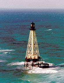 |
East of Indian Key near the Upper and Lower Matecumbe Keys |
24°51′6″N 80°37′6″W / 24.85167°N 80.61833°W / 24.85167; -80.61833 (Alligator Reef Light) |
1873 |
Active |
&&&&&&&+136 ft (41.4 m) |
|
| Amelia Island Light |
 |
N end of Amelia Island, at the mouth of St. Mary's River |
30°40′23.46″N 81°26′32.8″W / 30.6731833°N 81.442444°W / 30.6731833; -81.442444 (Amelia Island Light) |
1838 |
Active |
&&&&&&&+107 ft (32.6 m) |
Oldest existing active lighthouse in Florida |
| Amelia Island North Range Light |
 |
At the mouth of St. Mary's River |
30°42′09″N 81°26′26″W / 30.70250°N 81.44056°W / 30.70250; -81.44056 (Amelia Island North Range Light) |
1872 |
1899 |
&&&&&&&&+30 ft (9.1 m) |
Nonextant |
| American Shoal Light |
 |
East of the Saddlebunch Keys, close to Looe Key |
24°31′30″N 81°31′12″W / 24.52500°N 81.52000°W / 24.52500; -81.52000 (American Shoal Light) |
1880 |
Active |
&&&&&&&+109 ft (33.2 m) |
|
| Anclote Keys Light |
 |
Anclote Key at the mouth of Anclote River near Tarpon Springs, Florida |
28°10′01.11″N 82°50′40.74″W / 28.1669750°N 82.8446500°W / 28.1669750; -82.8446500 (Anclote Keys Light) |
1887 |
Active |
&&&&&&&+110 ft (33.5 m) |
Inactive from 1984 to 2003 |
| Cape Canaveral Light (1) |
 |
north of Launch Complex 46 inside the Cape Canaveral Air Force Station |
28°27′36.8″N 80°31′37.9″W / 28.460222°N 80.527194°W / 28.460222; -80.527194 (Cape Canaveral Light 1848) |
1848 |
1868 |
&&&&&&&&+60 ft (18.3 m) |
Located next to its replacement, the 1868 Cape Canaveral lighthouse; destroyed in 1893 for used as foundation material when the 1868 tower was relocated |
| Cape Canaveral Light (2) |
 |
1 mile (1.6 km) inland from Cape Canaveral, inside the Air Force Station |
28°27′37.26″N 80°32′36.42″W / 28.4603500°N 80.5434500°W / 28.4603500; -80.5434500 (Cape Canaveral Light) |
1868 |
Active |
&&&&&&&+137 ft (41.8 m) |
The tower is 151 feet (46 m) tall. |
| Cape Florida Light (1) |
|
Cape Florida, south of Key Biscayne |
25°39′59.72″N 80°09′21.47″W / 25.6665889°N 80.1559639°W / 25.6665889; -80.1559639 (Cape Florida Light) |
1825 |
1836 |
&&&&&&&&+65 ft (19.8 m) |
Burned down during a Seminole attack |
| Cape Florida Light (2) |
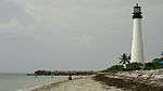 |
Cape Florida, South of Key Biscayne |
25°39′59.72″N 80°09′21.47″W / 25.6665889°N 80.1559639°W / 25.6665889; -80.1559639 (Cape Florida Light) |
1847 |
Active |
&&&&&&&&+95 ft (29.0 m) |
Third oldest existing active lighthouse in Florida; Inactive from 1878 to 1978 |
| Cape San Blas Light |
 |
On Cape San Blas, southwest of Port St. Joe |
29°40′16.41″N 85°21′22.72″W / 29.6712250°N 85.3563111°W / 29.6712250; -85.3563111 (Cape San Blas Light) |
1885 |
Active |
&&&&&&&+101 ft (30.8 m) |
|
| Cape St. George Light (1) |
 |
Little St. George Island, Apalachicola Bay |
29°35′15.2″N 85°02′49.32″W / 29.587556°N 85.0470333°W / 29.587556; -85.0470333 (Cape St. George Light) |
1852 |
2005 |
&&&&&&&&+72 ft (21.9 m) |
Tower collapsed in 2005 and was reconstructed in St. George Island |
| Cape St. George Light (2) |
 |
St. George Island, Apalachicola Bay |
29°39′46.1″N 84°51′45.2″W / 29.662806°N 84.862556°W / 29.662806; -84.862556 (Cape St. George Light) |
2008 |
Active |
&&&&&&&&+72 ft (21.9 m) |
Inactive 2005 to 2008 |
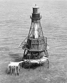
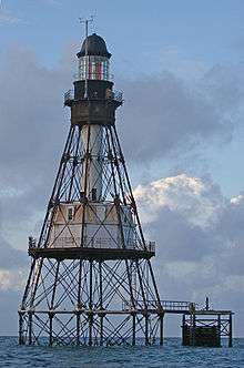
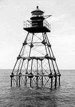
| Carysfort Reef Light |
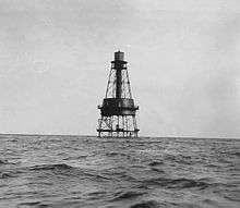 |
6 miles (9.7 km) East of Key Largo |
25°13′18″N 80°12′42″W / 25.22167°N 80.21167°W / 25.22167; -80.21167 (Carysfort Reef Light) |
1852 |
Active |
&&&&&&&+100 ft (30.5 m) |
Oldest existing screw-pile lighthouse still in service in the United States |
| Cedar Key Light |
 |
On Seahorse Key across the harbor from Cedar Key, Florida |
29°05′47.33″N 83°03′55″W / 29.0964806°N 83.06528°W / 29.0964806; -83.06528 (Cedar Key Light) |
1854 |
1915 |
&&&&&&&&+75 ft (22.9 m) |
Now serves as a Marine Laboratory for the University of Florida |
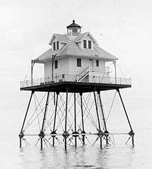
| Charlotte Harbor Light |
 |
On Charlotte Harbor in Punta Gorda, FL |
26°45′35″N 82°06′29″W / 26.75972°N 82.10806°W / 26.75972; -82.10806 (Charlotte Harbor Light) |
1890 |
1943 |
&&&&&&&&+36 ft (11.0 m) |
Demolished in 1943; Iron pilings removed in 1915 |
| Cosgrove Shoal Light (1) |
|
10 miles (16 km) WSW of Key West
S of Marquesas Keys |
24°27′28.44″N 82°11′6.16″W / 24.4579000°N 82.1850444°W / 24.4579000; -82.1850444 (Cosgrove Shoal Light) |
1935 |
Unknown |
&&&&&&&&+49 ft (14.9 m) |
[1] |
| Cosgrove Shoal Light (2) |
|
10 miles (16 km) WSW of Key West
S of Marquesas Keys |
24°27′28.44″N 82°11′6.16″W / 24.4579000°N 82.1850444°W / 24.4579000; -82.1850444 (Cosgrove Shoal Light) |
Unknown |
Active |
&&&&&&&&+54 ft (16.5 m) |
[2] |
| Crooked River Light |
 |
Dog Island off Carrabelle |
29°49′39″N 84°42′04″W / 29.82750°N 84.70111°W / 29.82750; -84.70111 (Crooked River Light) |
1895 |
Active |
&&&&&&&+115 ft (35.0 m) |
|
| Dames Point Light |
|
On the shoals off Dames Point on St. Johns River near Jacksonville, Florida |
30°23′00″N 81°33′16″W / 30.38333°N 81.55444°W / 30.38333; -81.55444 (Dames Point Light) |
1872 |
1893 |
&&&&&&&&+35 ft (10.7 m) |
No remnants of the screw-pile lighthouse |
| Dog Island Light |
 |
Western tip of Dog Island south of Carrabelle, Florida |
29°47′N 84°40′W / 29.783°N 84.667°W / 29.783; -84.667 (Dog Island Light) |
1851 |
1872 |
&&&&&&&&+70 ft (21.3 m) |
Nonextant, destroyed by a hurricane in 1873; replaced by the Crooked River Light |
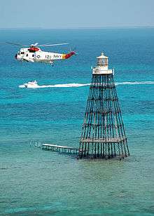
| Dry Tortugas Light |
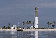 |
Loggerhead Key, Dry Tortugas 3 mi (4.8 km) W of Fort Jefferson |
24°38′00″N 82°55′12″W / 24.63333°N 82.92000°W / 24.63333; -82.92000 (Dry Tortugas Light) |
1858 |
Active |
&&&&&&&+151 ft (46.0 m) |
The third tallest lighthouse tower in Florida at 157 ft (48 m) |
| Egmont Key Light (2) |
 |
North end of Egmont Key, at the entrance to Tampa Bay |
27°36′03″N 82°45′39″W / 27.60083°N 82.76083°W / 27.60083; -82.76083 (Egmont Key Light) |
1858 |
Active |
&&&&&&&&+85 ft (25.9 m) |
Lantern was removed in 1944 |
| Fowey Rocks Light |
 |
7 miles (11 km) SE of Cape Florida on Key Biscayne |
25°35′26.25″N 80°05′48.24″W / 25.5906250°N 80.0967333°W / 25.5906250; -80.0967333 (Fowey Rocks Light) |
1878 |
Active |
&&&&&&&+110 ft (33.5 m) |
|
| Garden Key Light |
 |
On top of Fort Jefferson at Dry Tortugas National Park |
24°37′41″N 82°52′20″W / 24.62806°N 82.87222°W / 24.62806; -82.87222 (Garden Key Light) |
1877 |
Active |
&&&&&&&&+70 ft (21.3 m) |
Operates as a private aid |
| Gasparilla Island Light |
 |
South of Gasparilla Island, on the Boca Grande Pass |
26°43′02″N 82°15′39″W / 26.71722°N 82.26083°W / 26.71722; -82.26083 (Boca Grande Light Rear) |
1932 |
Active |
&&&&&&&+105 ft (32.0 m) |
|
| Hen and Chickens Shoal Light |
|
2 mi (3.2 km) southeast of Plantation Key |
24°55′58.69″N 80°32′55.36″W / 24.9329694°N 80.5487111°W / 24.9329694; -80.5487111 (Hen and Chickens Shoal Light) |
1929 |
Active |
&&&&&&&&+35 ft (10.7 m) |
|
| Hillsboro Inlet Light |
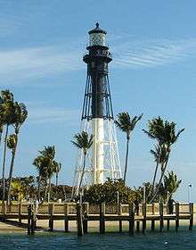 |
North of Hillsboro Inlet, near Hillsboro Beach |
26°15′33″N 80°04′51″W / 26.25917°N 80.08083°W / 26.25917; -80.08083 (Hillsboro Inlet Light) |
1907 |
Active |
&&&&&&&+136 ft (41.4 m) |
|
| Jupiter Inlet Light |
 |
North of Jupiter Inlet in Jupiter, Florida |
26°56′55″N 80°04′55″W / 26.94861°N 80.08194°W / 26.94861; -80.08194 (Jupiter Inlet Light) |
1860 |
Active |
&&&&&&&+146 ft (44.5 m) |
The height of the tower is 108 ft (33 m). |
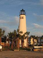
| Key West Light |
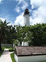 |
On Whitehead St., downtown Key West |
24°33′2.16″N 81°48′2.52″W / 24.5506000°N 81.8007000°W / 24.5506000; -81.8007000 (Key West Light) |
1849 |
1969 |
&&&&&&&&+91 ft (27.7 m) |
Operates as a museum |
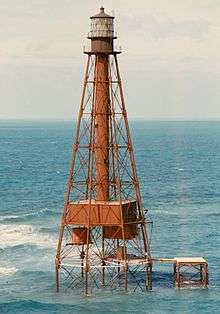
| Molasses Reef Light |
 |
8 miles (13 km) SE of Key Largo |
25°00′42.66″N 80°22′35.31″W / 25.0118500°N 80.3764750°W / 25.0118500; -80.3764750 (Molasses Reef Light) |
1921 |
Active[3] |
&&&&&&&&+45 ft (13.7 m) |
Also operates as an Automatic weather station |
| Northwest Passage Light |
 |
Entrance to the northwest channel to the Key West Harbor. |
24°37′8.31″N 81°53′56.71″W / 24.6189750°N 81.8990861°W / 24.6189750; -81.8990861 (Northwest Passage Light) |
1855 |
1971 |
&&&&&&&&+47 ft (14.3 m) |
The wooden structure burned down in 1971; only the iron pilings remain |
| Pacific Reef Light |
 |
3 miles (4.8 km) SE of Elliott Key |
25°22′15.55″N 80°08′31.41″W / 25.3709861°N 80.1420583°W / 25.3709861; -80.1420583 (Pacific Reef Light) |
1921 |
Active |
&&&&&&&&+44 ft (13.7 m) |
|
| Pensacola Light |
 |
Entrance to Pensacola Bay, Pensacola |
30°20′47″N 87°18′29″W / 30.34639°N 87.30806°W / 30.34639; -87.30806 (Pensacola Light) |
1858 |
Active |
&&&&&&&+191 ft (58.2 m) |
Tower height is 150 ft (46 m). |
| Ponce de Leon Inlet Light |
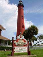 |
Ponce Inlet, Florida, south of Daytona Beach |
29°04′49″N 80°55′41″W / 29.08028°N 80.92806°W / 29.08028; -80.92806 (Ponce de Leon Inlet Light) |
1887 |
Active |
&&&&&&&+159 ft (48.4 m) |
The tallest lighthouse tower in Florida at 175.0 ft (53.3 m);[4] the third tallest tower in the United States |
| Port Boca Grande Light |
 |
Southern tip of Gasparilla Island in Boca Grande, Florida |
26°43′02″N 82°15′39″W / 26.71722°N 82.26083°W / 26.71722; -82.26083 (Port Boca Grande Light) |
1890 |
Active |
&&&&&&&&+41 ft (12.5 m) |
Inactive from 1966 to 1986; also a museum |
| Pulaski Shoal Light (1) |
 |
30 miles (48 km) NW of Key West, north of the Dry Tortugas |
24°41′36.02″N 82°46′22.79″W / 24.6933389°N 82.7729972°W / 24.6933389; -82.7729972 (Pulaski Shoal Light) |
1935 |
Unknown |
&&&&&&&&+49 ft (14.9 m) |
Nonextant |
| Pulaski Shoal Light (2) |
|
30 miles (48 km) NW of Key West, north of the Dry Tortugas |
24°41′36.02″N 82°46′22.79″W / 24.6933389°N 82.7729972°W / 24.6933389; -82.7729972 (Pulaski Shoal Light) |
Unknown |
Active |
&&&&&&&&+56 ft (17.1 m) |
[5] |
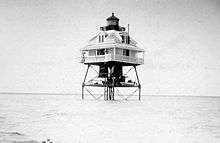
| Rebecca Shoal Light (1) |
 |
10 miles (16 km) W of the Marquesas Keys |
24°34′42″N 82°35′06″W / 24.57833°N 82.58500°W / 24.57833; -82.58500 (Rebecca Shoal Light) |
1886 |
1953 |
&&&&&&&&+66 ft (20.1 m) |
The original lantern was mounted to a private lighthouse in Key Largo, Florida. |
| Rebecca Shoal Light (4) |
|
10 miles (16 km) W of the Marquesas Keys |
24°34′44.48″N 82°35′6.78″W / 24.5790222°N 82.5852167°W / 24.5790222; -82.5852167 (Rebecca Shoal Light) |
2004 |
Active |
&&&&&&&&+66 ft (20.1 m) |
[6] |
| Sand Key Light |
 |
8 miles (13 km) miles SW of Key West, adjacent to the Southwest Channel |
24°27′14.18″N 81°52′39.02″W / 24.4539389°N 81.8775056°W / 24.4539389; -81.8775056 (Sand Key Light) |
1853 |
Active |
&&&&&&&+109 ft (33.2 m) |
|
| Sanibel Island Light |
 |
E end of Sanibel Island |
26°27′10.51″N 82°00′51.32″W / 26.4529194°N 82.0142556°W / 26.4529194; -82.0142556 (Sanibel Island Light) |
1885 |
Active |
&&&&&&&&+98 ft (29.9 m) |
|
| Smith Shoal Light (1) |
|
11 miles (18 km) NNW of Key West |
24°43′5.82″N 81°55′17.54″W / 24.7182833°N 81.9215389°W / 24.7182833; -81.9215389 (Smith Shoal Light) |
1933 |
Unknown |
&&&&&&&&+49 ft (14.9 m) |
|
| Smith Shoal Light (2) |
|
11 miles (18 km) NNW of Key West |
24°43′5.82″N 81°55′17.54″W / 24.7182833°N 81.9215389°W / 24.7182833; -81.9215389 (Smith Shoal Light) |
Unknown |
Active |
&&&&&&&&+54 ft (16.5 m) |
[5] |
| Sombrero Key Light |
 |
Near Key Vaca in Marathon |
24°37′40.46″N 81°06′41.78″W / 24.6279056°N 81.1116056°W / 24.6279056; -81.1116056 (Sombrero Key Light) |
1858 |
Active |
&&&&&&&+142 ft (43.3 m) |
Highest light from a screw-pile lighthouse in Florida |
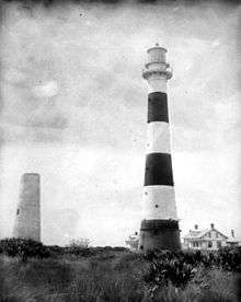
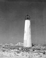
| St. Augustine Light (1) |
 |
Anastasia Island, St. Augustine |
Unknown |
1737 |
1874 |
&&&&&&&&+52 ft (15.8 m) |
Destroyed by the ocean in 1880; tower ruins can still be seen during low tide |
| St. Augustine Light (2) |
 |
N Anastasia Island, St. Augustine |
29°53′08″N 81°17′19″W / 29.88556°N 81.28861°W / 29.88556; -81.28861 (St. Augustine Light) |
1874 |
Active |
&&&&&&&+161 ft (49.1 m) |
Second tallest lighthouse tower in Florida at 165 ft (50 m) |
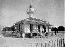
| St. Johns Light |
 |
0.75 miles (1.21 km) S of the mouth of the St. Johns River Naval Station Mayport near Jacksonville |
30°23′10″N 81°23′53″W / 30.38611°N 81.39806°W / 30.38611; -81.39806 (St. Johns Light) |
1954 |
Active |
&&&&&&&&+83 ft (25.3 m) |
Constructed to replace a lightship; Never had a traditional lantern |
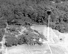
| St. Johns River Light |
 |
Near the mouth of St. Johns River inside Naval Station Mayport |
30°23′36.77″N 81°25′33.49″W / 30.3935472°N 81.4259694°W / 30.3935472; -81.4259694 (St. Johns River Light) |
1859 |
1929 |
&&&&&&&&+81 ft (24.7 m) |
Replaced by a lightship in 1929 |
| St. Joseph Bay Light |
|
On St. Joseph Point at the end of St. Joseph Peninsula |
29°53′N 85°23′W / 29.883°N 85.383°W / 29.883; -85.383 (St. Joseph Bay Light) |
1839 |
1847 |
&&&&&&&&+50 ft (15.2 m) |
Lighthouse lantern was moved to the new Cape San Blas Light in 1847; tower was washed away in 1851 |
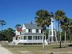
| St. Joseph Point Rear Range Light |
 |
Entrance to St. Joseph Bay, on Beacon Hill (mainland) |
29°55′5.67″N 85°22′49.79″W / 29.9182417°N 85.3804972°W / 29.9182417; -85.3804972 (St. Joseph Point Rear Range Light) |
1902 |
1960 |
&&&&&&&&+78 ft (23.8 m) |
Replaced with a skeletal steel tower in 1960; the old lighthouse was moved and is now a private residence |
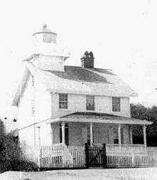
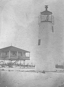
| St. Marks Light (1) |
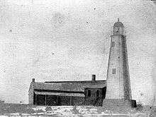 |
On mouth of St. Marks River, St. Marks on Apalachee Bay |
Unknown |
1831 |
1842 |
&&&&&&&&+65 ft (19.2 m) |
Demolished and moved to a new location |
| St. Marks Light (2) |
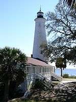 |
On mouth of St. Marks River, St. Marks on Apalachee Bay |
30°04′19″N 84°10′48″W / 30.07194°N 84.18000°W / 30.07194; -84.18000 (St. Marks Light) |
1842 |
Active |
&&&&&&&&+82 ft (25.0 m) |
Second oldest existing active lighthouse in Florida |
| Tennessee Reef Light |
 |
S of Long Key, in the middle Florida Keys |
24°44′45.88″N 80°46′56.47″W / 24.7460778°N 80.7823528°W / 24.7460778; -80.7823528 (Tennessee Reef Light) |
1933 |
Active |
&&&&&&&&+49 ft (14.9 m) |
|
| Volusia Bar Light |
 |
Entrance to St. Johns River on the S side of Lake George, Florida |
29°12′24″N 81°34′46″W / 29.20667°N 81.57944°W / 29.20667; -81.57944 (Volusia Bar Light) |
1886 |
1916 |
&&&&&&&&+34 ft (10.4 m) |
The building was burned down by vandals in 1974; some cast iron foundation piles remain. |