Listed buildings in Sebergham
Sebergham is a civil parish in the Borough of Allerdale in Cumbria, England. It contains 33 listed buildings that are recorded in the National Heritage List for England. Of these, four are listed at Grade II*, the middle of the three grades, and the others are at Grade II, the lowest grade. The parish contains the village of Sebergham and the hamlet of Welton, and is otherwise rural. Most of the listed buildings are houses and associated structures, farmhouses and farm buildings. The other listed buildings include a medieval church, former mills, bridges, and a boundary stone.
Key
| Grade | Criteria[1] |
|---|---|
| II* | Particularly important buildings of more than special interest |
| II | Buildings of national importance and special interest |
Buildings
| Name and location | Photograph | Date | Notes | Grade |
|---|---|---|---|---|
| St Mary's Church 54°46′03″N 2°59′24″W / 54.76752°N 2.98992°W |
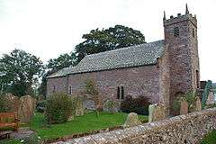 |
Medieval | The church is in Early English style, the tower was added in 1825, and the church was restored in 1880 and 1905. It is in sandstone and has a green slate roof with coped gables. The church consists of a nave and a chancel in one unit, and a west tower incorporating a porch. The tower is in three stages, its entrance has an alternate-block surround and voussoirs, external steps lead to a first floor door, and there is an embattled parapet with pinnacles. Inside the church is a three-light oriel window over the west door.[2][3] | II* |
| Courtyard range, gatehouse and barn, Warnell Hall 54°45′46″N 3°00′38″W / 54.76265°N 3.01066°W |
— |
Early 16th century (probable) | Originally part of a fortified courtyard range, the buildings are in sandstone rubble with roofs of Welsh slate and sandstone slate. The gatehouse is higher, and contains a segmental through arch with internal niches. Its upper floor is corbelled out, and has a three-light round-headed mullioned window. The barn contains original 16th-century window openings.[4] | II* |
| Warnell Hall 54°45′46″N 3°00′39″W / 54.76271°N 3.01090°W |
— |
Early or mid-16th century | Originally a fortified house, later a farmhouse, it incorporates part of a 14th-century tower. The house is in calciferous and pink sandstone, and has a green slate roof. It has two storeys, five bays, a stair projection to the rear, and a single-story rear extension dating probably from the 18th century. The doorway has an alternate-block surround, a cornice, and a voussoir frieze. The windows are mullioned, some with cornices, and some with hood moulds.[5] | II* |
| Woodshed, Bridge End 54°46′04″N 2°59′59″W / 54.76777°N 2.99978°W |
— |
Early or mid-17th century | Originally a house, later used as an outbuilding, and reduced from two storeys to one. It is in sandstone rubble with a roof mainly of Welsh slate and partly of sandstone slate. It has one storey and three bays. The central doorway has a Tudor arched lintel, to the right is a chamfered mullioned window with a hood mould, and to the left is a 20th-century window and entrance. Inside the building is a pair of upper crucks.[6] | II |
| Bellbridge Farmhouse 54°46′44″N 2°59′24″W / 54.77878°N 2.98989°W |
— |
Mid-17th century | The farmhouse was extended to the rear in the late 17th century. The house is rendered with quoins, an eaves cornice, and a Welsh slate roof. There are two storeys, and both parts have three bays. The older part has a doorway with a bolection architrave and a swan-neck pediment containing a carved stone coat of arms, and the windows are cross-mullioned. The later part has a door with a chamfered surround and a hood mould. There are some original small windows, and the others are 20th-century casements. There is a single-storey extension to the right with a stone slate roof.[7] | II |
| Barn, Fellhill Farm 54°45′39″N 3°01′29″W / 54.76079°N 3.02477°W |
— |
17th century (probable) | A field barn in rubble with quoins, it has a stone slate roof with coped gables. The openings include a square-headed doorway with a wooden lintel, narrow ventilation slits, and an owl hole.[8] | II |
| Shippon, Fellhill Farm 54°45′39″N 3°01′30″W / 54.76071°N 3.02499°W |
— |
1668 | The shippon is in mixed rubble with quoins, and it has a stone slate roof with coped gables. There are two low storeys, three bays, and slim ventilation slits. The western bay contains a square doorway with a moulded surround, an inscribed lintel, and a hood mould. There is also a loading doorway with chamfered jambs. In the eastern bay is a doorway with a plain surround and two rectangular chamfered windows.[9] | II |
| Gateposts, Bellbridge Farmhouse 54°46′44″N 2°59′24″W / 54.77889°N 2.98996°W |
— |
Late 17th century | The gateposts are in stone. Each consists of a rusticated pier on a chamfered plinth, with a cornice and a ball finial.[10] | II |
| Sebergham Hall 54°46′22″N 2°59′26″W / 54.77287°N 2.99062°W |
— |
Late 17th century | A country house in calciferous and pink sandstone on a chamfered plinth, with quoins, an eaves cornice, and a green slate roof with coped gables. It has two storeys, the main part having five bays, and with a lower three-bay extension to the right. The doorway has a bolection architrave, a carved leaf frieze, and a broken segmental pediment on console brackets. Most of the windows are sashes; those in the ground floor of the main part of the house have alternate triangular and segmental broken pediments. In the extension and at the rear are dated and inscribed lintels.[11][12] | II* |
| Sowerby Mill 54°45′52″N 3°00′02″W / 54.76450°N 3.00052°W |
— |
Late 17th century | Originally the miller's house with an attached stable, later a private house. It is in sandstone rubble with a green slate roof. There are two storeys, the original house had three bays, with a two-bay stable to the left. The windows are mullioned and contain 20th-century casements. Inside the house are an inglenook and a bressumer.[13] | II |
| The Kennels, The Kennels Cottage and barns 54°47′21″N 3°00′22″W / 54.78917°N 3.00603°W |
— |
1682 | A row of two houses and barns, The Kennels Cottage dating from the 18th century. They are in rendered sandstone, the houses have Welsh slate roofs, and the barn has a corrugated asbestos roof. On the right, The Kennels Cottage has two storeys, three bays and one casement window, the other windows being sashes. To the left is a barn with a blank front. Further to the left is The Kennels, with two storeys, three bays, an entrance with a moulded surround and a shaped lintel, partly cut away. To the left of this is an angled barn with a similar entrance and a shaped, dated lintel. At the rear is a large cart entrance.[14] | II |
| Byres, Bellbridge Farm 54°46′44″N 2°59′24″W / 54.77902°N 2.99005°W |
— |
1688 | The building originated as a house with an attached barn. It is in sandstone rubble, with a roof mainly of Welsh slate and with some sandstone slate. The former house has two storeys and two bays with the barn to the right, and there is a single-storey extension at right angles giving an L-shaped plan. In the house is a doorway with a dated and inscribed lintel, casement windows with chamfered surrounds and a continuous hood mould in the ground floor, and mullioned windows and a loft door above. In the former barn are doorways, ventilation slits, and a loft door. The extension is partly in brick and incorporates a former gate pier with a ball finial.[15] | II |
| Lanehead and barns 54°46′55″N 2°59′39″W / 54.78200°N 2.99412°W |
— |
1688 | The farmhouse and barns are in sandstone rubble, and they have roofs mainly of green slate and some sandstone slate, with coped gables. The barns date from the late 18th or early 19th century. The house has two storeys, three bays, and a lower earlier rendered single bay to the right. The doorway has a bolection architrave and a cornice, and the windows are sashes, some of which are horizontally sliding. The barns are to the rear, in an L-shape, forming an overall U-shaped plan. They contain doorways with segmental arches and a through cart entrance.[16] | II |
| Sebergham Bridge 54°46′03″N 3°00′01″W / 54.76743°N 3.00040°W |
 |
1689 | The bridge carries the B5305 road over the River Caldew. It is in sandstone, and consists of two segmental arches on a central pier with splayed cutwaters. The bridge has solid parapets with chamfered coping and end piers.[2][17] | II |
| Greenfoot and former barn 54°46′11″N 3°00′02″W / 54.76964°N 3.00052°W |
— |
1715 | The house and former barn incorporate an earlier house of 1687. The main part is rendered on a chamferde plinth with a green slate roof; the older part is in sandstone rubble with a roof of Welsh, green, and sandstone slate. The house has two storeys, the main part is in a double span with five bays, the older part is to the right, and the former barn is at right angles, giving an L-shaped plan. The doorway has an architrave and an open segmental pediment, and the windows are casements with chamfered surrounds. At the rear of the barn is a doorway with a re-set dated lintel.[11][18] | II |
| Borrans Hill Farmhouse and barn 54°47′29″N 2°59′45″W / 54.79126°N 2.99584°W |
— |
1716 | The barn was extended in the late 18th century. The farmhouse and barn are in sandstone rubble. The house has a roof mainly of green slate with some sandstone slate. There are two storeys, two bays, and a doorway with a chamfered surround and an inscribed and dated lintel. Some of the windows are mullioned containing 20th-century casements, there is a blocked fire window, and a horizontally sliding sash window. The barn has a sandstone slate roof, and its extension has a Welsh slate roof. It contains plank doors, ventilation slits, loft doors, small windows, and a large projecting cart entrance.[19] | II |
| Floshfield and adjoining barn 54°45′59″N 2°59′21″W / 54.76645°N 2.98917°W |
— |
Early 18th century | The house is roughcast with a roof mainly of Welsh slate and partly of sandstone slate. It has two storeys and four bays, and contains sash windows with stone surrounds, some also with cornices. The doorway has a bolection architrave with a cornice. The barn to the left is in sandstone rubble with a corrugated asbestos roof, a cart entrance with alternate-block surround, another entrance, a casement window, and a smaller window.[20] | II |
| Ling and barn 54°47′54″N 3°00′59″W / 54.79847°N 3.01636°W |
— |
Early 18th century | The farmhouse is in rendered sandstone with an eaves cornice and a Welsh slate roof. It has two storeys, three bays, and sash windows in stone surrounds. To the right is a lower barn in sandstone rubble with a sandstone slate roof. There are external stone steps to a first floor loft door.[21] | II |
| Brow Top Farmhouse and barns 54°46′04″N 2°59′58″W / 54.76787°N 2.99958°W |
— |
1730 | The house incorporates part of a 17th-century house. The house and barns are roughcast. The house is on a chamfered plinth, and has quoins, an eaves cornice, and a green slate roof with coped gables. Some windows are mullioned, and others have been replaced by sashes. The doorway has a bolection surround with a keystone, a frieze, and a fanlight. The barns have sandstone slate roofs and, with the house, form a U-shaped plan, and inside is a pair of upper crucks. Inside the house is an inglenook and a bressumer.[22][23] | II |
| Bridge End 54°46′04″N 2°59′58″W / 54.76789°N 2.99957°W |
— |
1737 | The house incorporates part of a 1670 house, but this has been much rebuilt. The house is in sandstone with quoins, and it has a sandstone slate roof with coped gables. There are two storeys, the 1737 part has three bays, and the 1670 part has two. There is also a single-storey extension at right angles at the front dating probably from the 17th century. Many of the windows are mullioned, and others date from the 20th century. There is a dated and inscribed lintel that has been moved from its original position. Inside the 1737 part is an inglenook and a bressumer.[11][24] | II |
| Limetree Grove 54°45′57″N 2°59′37″W / 54.76576°N 2.99348°W |
— |
1761 | A roughcast farmhouse with quoins and a Welsh slate roof. It has two storeys, three bays, and sash windows in stone surrounds. The doorway has an alternate-block surround, a dated keystone, and a fanlight.[25] | II |
| Churchtown Farmhouse 54°45′58″N 2°59′20″W / 54.76607°N 2.98886°W |
— |
1769 | The farmhouse was extended in the late 18th century. It is rendered with quoins and a green slate roof. There are two storeys and three bays, with a lower two-storey single-bay extension to the left. The doorway has an architrave and a triangular pediment. The windows are sashes with stone surrounds, some are double, and the window above the doorway has an architrave.[26] | II |
| Bell Bridge 54°46′40″N 2°59′14″W / 54.77789°N 2.98728°W |
 |
1772 | The bridge carries a road over the River Caldew. It is a hump-backed sandstone bridge, and consists of a single segmental arch. The bridge has a solid parapet with chamfered coping.[27] | II |
| Barn, Bellbridge Farm 54°46′44″N 2°59′22″W / 54.77893°N 2.98939°W |
— |
1774 | The barn is in sandstone rubble with a sandstone slate roof. There is a central cart entrance with a segmental arch and an alternate-block surround, and two levels of ventilation slits. The doorway has a dated lintel. Incorporated into a 20th-century brick extension is a re-used late 17th-century gate pier with a ball finial.[28] | II |
| Lonning Foot 54°46′06″N 3°00′13″W / 54.76847°N 3.00370°W |
— |
Late 18th century | A house in sandstone rubble with a roof mainly of green slate and some Welsh slate. There are two storeys and two bays, with a long single-storey extension to the right. The windows are sashes in stone surrounds, and the doorway has a pilastered surround with a false keystone, and a fanlight.[29] | II |
| Sebergham Castle, barn and stable 54°46′52″N 3°02′35″W / 54.78106°N 3.04304°W |
— |
Late 18th century | A farmhouse later divided into two dwellings, with flanking farm buildings, all with green slate roofs. The house is rendered on a chamfered plinth, with string courses and a battlemented parapet. The house has two storeys and three bays. The doorway and the ground floor casement windows have ogee heads, and in the upper floor are mullioned with hood moulds. The house is flanked by battlemented screen walls containing ogee-headed doorways. At the ends of the walls are gabled wings at right-angles with ball finials, one a barn, the other a stable.[11][30] | II |
| Brisco House 54°45′58″N 2°59′46″W / 54.76599°N 2.99624°W |
— |
Late 18th or early 19th century | A roughcast brick house on a stone plinth with a green slate roof. There are two storeys, two bays, and sash windows with stone sills and keystones. The doorway has a pilastered surround and a pediment.[31] | II |
| Crookholme Mill 54°46′57″N 2°59′27″W / 54.78241°N 2.99081°W |
— |
Late 18th or early 19th century | A former water mill in mixed sandstone rubble and cobbles on a chamfered plinth, with sandstone quoins and a hipped green slate roof. There are two storeys and two bays in an L-shape, with another bay to the left. Steps lead up to the doorway in a loading porch, and the windows are casements. There is a wheelhouse to the right containing the remains of an undershot wheel and much of the internal machinery.[32] | II |
| Byres, Floshfield 54°45′59″N 2°59′20″W / 54.76646°N 2.98891°W |
— |
Late 18th or early 19th century | The byres are in sandstone rubble with a corrugated asbestos roof, and have two storeys and two bays. The openings include plank doors in stone surrounds, a casement window with a sash window above it, and a loft door.[33] | II |
| Sowerby Mill House 54°45′51″N 3°00′02″W / 54.76427°N 3.00045°W |
— |
Late 18th or early 19th century | Originally a water mill, later a private house, it is in sandstone rubble with quoins and a tile roof. There are two storeys and five bays, the right bay being gabled and forming an L-shaped plan. There are external stone steps leading to a first floor doorway. The doors and windows date from the 20th century. At the end of the right wall is an external mill wheel, and inside the end bay is complete mill machinery.[34] | II |
| Welton Farmhouse and barn 54°47′22″N 3°00′27″W / 54.78938°N 3.00758°W |
— |
Late 18th or early 19th century | The farmhouse is stuccoed with quoins. and it has a green slate roof with coped gables. There are two storeys and three bays. The doorway has a Tuscan doorcase with a pediment and a radial fanlight. To the left is a lower two-storey house extension and barn in sandstone rubble, partly stuccoed, and with a roof mainly of Welsh slate, and partly of sandstone slate. The windows are sashes in stone surrounds.[35] | II |
| Boundary stone 54°46′44″N 3°01′38″W / 54.77894°N 3.02716°W |
— |
Early 19th century (probable) | The boundary stone is in calciferous sandstone. It consists of an irregular square with an inscription on the front reading "SEBERGHAM HIGH" and an illegible inscription on the back.[36] | II |
| Bridge Cottage 54°46′03″N 2°59′58″W / 54.76744°N 2.99952°W |
— |
Early 19th century | A sandstone house with quoins and a green slate roof. It has two storeys and two bays, with a lower single-bay extension to the right, and a brick outhouse to the left. There is a gabled porch with fretwork decoration, and a doorway with a pilastered surround and a fanlight. The windows are sashes with stone surrounds. The openings in the outhouse have pointed heads.[37] | II |
References
Citations
- ↑ Historic England
- 1 2 Hyde & Pevsner (2010), p. 610
- ↑ Historic England (1327246)
- ↑ Historic England (1144400)
- ↑ Historic England (1311727)
- ↑ Historic England (1144396)
- ↑ Historic England (1146486)
- ↑ Historic England (1320582)
- ↑ Historic England (1238633)
- ↑ Historic England (1327224)
- 1 2 3 4 Hyde & Pevsner (2010), p. 611
- ↑ Historic England (1144392)
- ↑ Historic England (1157892)
- ↑ Historic England (1157945)
- ↑ Historic England (1146493)
- ↑ Historic England (1327225)
- ↑ Historic England (1144395)
- ↑ Historic England (1327247)
- ↑ Historic England (1144431)
- ↑ Historic England (1144390)
- ↑ Historic England (1144401)
- ↑ Hyde & Pevsner (2010), pp. 610–611
- ↑ Historic England (1157910)
- ↑ Historic England (1157881)
- ↑ Historic England (1146515)
- ↑ Historic England (1144432)
- ↑ Historic England (1144429)
- ↑ Historic England (1144430)
- ↑ Historic England (1144394)
- ↑ Historic England (1144399)
- ↑ Historic England (1144398)
- ↑ Historic England (1146503)
- ↑ Historic England (1144391)
- ↑ Historic England (1144397)
- ↑ Historic England (1144393)
- ↑ Historic England (1146464)
- ↑ Historic England (1327248)
Sources
- Historic England, "Church of St Mary, Sebergham (1327246)", National Heritage List for England, retrieved 18 February 2016
- Historic England, "Courtyard range and gatehouse with barn adjoining, Warnell Hall, Sebergham (1144400)", National Heritage List for England, retrieved 17 February 2016
- Historic England, "Warnell Hall, Sebergham (1311727)", National Heritage List for England, retrieved 18 February 2016
- Historic England, "Woodshed outbuilding south-west of Bridge End, Sebergham (1144396)", National Heritage List for England, retrieved 17 February 2016
- Historic England, "Bellbridge Farmhouse, Sebergham (1146486)", National Heritage List for England, retrieved 18 February 2016
- Historic England, "Barn approximately 5 metres north-east of Shippon, Sebergham (1320582)", National Heritage List for England, retrieved 18 February 2016
- Historic England, "Shippon approximately 200 metres south of Fellhill Farm, Sebergham (1238633)", National Heritage List for England, retrieved 18 February 2016
- Historic England, "Gateposts in front of Bellbridge Farmhouse, Sebergham (1327224)", National Heritage List for England, retrieved 18 February 2016
- Historic England, "Sebergham Hall (1144392)", National Heritage List for England, retrieved 17 February 2016
- Historic England, "Sowerby Mill, Sebergham (1157892)", National Heritage List for England, retrieved 18 February 2016
- Historic England, "The Kennels and The Kennels Cottage and adjoining barns, Sebergham (1157945)", National Heritage List for England, retrieved 18 February 2016
- Historic England, "Byres to north of Bellbridge Farmhouse, Sebergham (1146493)", National Heritage List for England, retrieved 18 February 2016
- Historic England, "Lanehead and adjoining barns, Sebergham (1327225)", National Heritage List for England, retrieved 18 February 2016
- Historic England, "Sebergham Bridge (1144395)", National Heritage List for England, retrieved 17 February 2016
- Historic England, "Greenfoot and former barn, Sebergham (1327247)", National Heritage List for England, retrieved 18 February 2016
- Historic England, "Borrans Hill Farmhouse and adjoining barn, Sebergham (1144431)", National Heritage List for England, retrieved 17 February 2016
- Historic England, "Floshfield and adjoining barn, Sebergham (1144390)", National Heritage List for England, retrieved 17 February 2016
- Historic England, "Ling and adjoining barn, Sebergham (1144401)", National Heritage List for England, retrieved 17 February 2016
- Historic England, "Brow Top Farmhouse and adjoining barns, Sebergham (1157910)", National Heritage List for England, retrieved 18 February 2016
- Historic England, "Bridge End, Sebergham (1157881)", National Heritage List for England, retrieved 18 February 2016
- Historic England, "Limetree Grove, Sebergham (1146515)", National Heritage List for England, retrieved 18 February 2016
- Historic England, "Churchtown Farmhouse, Sebergham (1144432)", National Heritage List for England, retrieved 18 February 2016
- Historic England, "Bell Bridge, Sebergham (1144429)", National Heritage List for England, retrieved 17 February 2016
- Historic England, "Barn to north-east of Bellbridge Farmhouse, Sebergham (1144430)", National Heritage List for England, retrieved 17 February 2016
- Historic England, "Lonning Foot, Sebergham (1144394)", National Heritage List for England, retrieved 17 February 2016
- Historic England, "Sebergham Castle and barn and stable wings, Sebergham (1144399)", National Heritage List for England, retrieved 17 February 2016
- Historic England, "Brisco House, Sebergham (1144398)", National Heritage List for England, retrieved 17 February 2016
- Historic England, "Crookholme Mill, Sebergham (1146503)", National Heritage List for England, retrieved 18 February 2016
- Historic England, "Byres to east of Floshfield, Sebergham (1144391)", National Heritage List for England, retrieved 17 February 2016
- Historic England, "Sowerby Mill House, Sebergham (1144397)", National Heritage List for England, retrieved 17 February 2016
- Historic England, "Welton Farmhouse and adjoining barn, Sebergham (1144393)", National Heritage List for England, retrieved 17 February 2016
- Historic England, "Boundary stone (east of Brothybeck), Sebergham (1146464)", National Heritage List for England, retrieved 18 February 2016
- Historic England, "Bridge Cottage, Sebergham (1327248)", National Heritage List for England, retrieved 18 February 2016
- Historic England, Listed Buildings, retrieved 17 February 2016
- Hyde, Matthew; Pevsner, Nikolaus (2010) [1967], Cumbria, The Buildings of England, New Haven and London: Yale University Press, ISBN 978-0-300-12663-1
This article is issued from Wikipedia - version of the 10/20/2016. The text is available under the Creative Commons Attribution/Share Alike but additional terms may apply for the media files.