Sebergham
| Sebergham | |
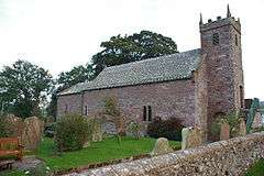 St. Mary's Church, Sebergham |
|
 Sebergham |
|
| Population | 365 (2011) |
|---|---|
| OS grid reference | NY357418 |
| Civil parish | Sebergham |
| District | Allerdale |
| Shire county | Cumbria |
| Region | North West |
| Country | England |
| Sovereign state | United Kingdom |
| Post town | CARLISLE |
| Postcode district | CA5 |
| Dialling code | 016974 |
| Police | Cumbria |
| Fire | Cumbria |
| Ambulance | North West |
| EU Parliament | North West England |
| UK Parliament | Penrith and The Border |
Coordinates: 54°46′01″N 2°59′56″W / 54.767°N 2.999°W
Sebergham is a small village and civil parish in the English county of Cumbria. It is located on the B5305, south of Carlisle and south-east of Wigton. The civil parish population at the 2011 Census was 365.[1]
St. Mary's church is medieval in origin, repaired in the 18th century and with a tower added in the 1820s. It is a Grade II* listed building and lies on the Cumbria Way walk.[2] The parish formed part of Inglewood Forest.[3] Sebergham Bridge dates from 1689 and Bell Bridge from 1772: both are Grade II listed.[4][5] Bell Bridge collapsed and was swept away by the river Caldew during the passing of the remnants of Storm Jonas on 27 January 2016. It had previously been damaged by Storm Desmond in December 2015.[6]
Sebergham Castle is a farmhouse, formerly known as Colerigg Hall, transformed in the Gothic Revival style in the late eighteenth century.[7] A mile to the south-west of the village is Warnell Hall, a fortified house which is now a farmhouse. It was built in the 16th century incorporating part of a 14th-century pele tower.[8]
See also
References
- ↑ "Civil Parish population 2011". Retrieved 26 January 2016.
- ↑ St. Mary's Church, Sebergham
- ↑ Higham, N.J. (1986). "The Origins of Inglewood Forest" (PDF). TCWAAS. 86: 85–100.
- ↑ Sebergham Bridge
- ↑ Bell Bridge
- ↑ "Bridge collapses in Cumbria". ITV News. 27 January 2016. Retrieved 8 July 2016.
- ↑ Sebergham Castle
- ↑ Warnell Hall
External links
| Wikimedia Commons has media related to Sebergham. |
- Map sources for Sebergham