Little Andaman
| Native name: <span class="nickname" ">Gaubolambe | |
|---|---|
 Little Andaman Island  Little Andaman Island | |
| Geography | |
| Location | Bay of Bengal |
| Coordinates | 10°39′N 92°29′E / 10.65°N 92.49°ECoordinates: 10°39′N 92°29′E / 10.65°N 92.49°E |
| Archipelago | Andaman Islands |
| Adjacent bodies of water | Indian Ocean |
| Total islands | 1 |
| Major islands |
|
| Area | 707 km2 (273 sq mi)[1] |
| Length | 24 km (14.9 mi) |
| Width | 43 km (26.7 mi) |
| Coastline | 132 km (82 mi) |
| Highest elevation | 183 m (600 ft)[2] |
| Administration | |
| District | South Andaman |
| Island group | Andaman Islands |
| Island sub-group | Little Andaman Group |
| Tehsil | Little Andaman Tehsil |
Largest settlement |
Kwate-tu-Kwage (Hut Bay) |
| Demographics | |
| Demonym | Hindi |
| Population | 18823 (2011) |
| Pop. density | 26.6 /km2 (68.9 /sq mi) |
| Ethnic groups | Hindu, Andamanese |
| Additional information | |
| Time zone | |
| PIN | 744207[3] |
| Telephone code | 031927 [4] |
| Official website |
www |
| ISO Code | IN-AN-00[5] |
| Literacy | 84.4% |
| Avg. summer temperature | 30.2 °C (86.4 °F) |
| Avg. winter temperature | 23.0 °C (73.4 °F) |
| Sex ratio | 1.2♂/♀ |
| unit_pref | Metric |
| Census Code | 35.640.0009 |
| Official Languages | Hindi, English |
Little Andaman Island (Onge: Gaubolambe) is the fourth largest of the Andaman Islands of India with an area of 707 km², lying at the southern end of the archipelago. It belongs to the South Andaman administrative district, part of the Indian union territory of Andaman and Nicobar Islands.[6] the island is lying 88 km (55 mi) south from Port Blair, the capital of Andaman and Nicobar Islands and the nearest airport from where regular flights to Calcutta and Chennai (Madras) are available.
Geography
The island belongs to the Little Andaman Group, and is separated from Rutland Archipelago in Great Andaman by the Duncan Passage. Little Andaman Group is counterpart of the Great Andaman island group. The low-lying island has widespread rainforest and several rare species of marine turtle. Little Andaman Island has white sandy beaches and bewitching waterfalls. The Little Andaman Lighthouse (a.k.a. Richardson's Lighthouse) is located 14 km south by road from Hut Bay port and is situated on the Southern tip of Little Andaman Island. [7]
Administration
Politically, Little Andaman Island is part of Little Andaman Tehsil.[8]
Demographics
The island is home to the Onge aboriginal tribe, who call the island Egu Belong, and has been a tribal reserve since 1957. Settlers from erstwhile Bengal and other places also live here. As per the census of 2011, the population was 18,823 in 4,093 households, spread among 18 villages. The main village of Kwate-tu-Kwage is located on Hut Bay.
Transportation
Hut Bay wharf, a deep water wharf that can be approached through a gap in the coral reef, on the east coast of the island is the entry point of Little Andaman Island. Daily boat services connect Hut Bay wharf with Port Blair in ten hours voyage. Additionally, there are a helicopter services by Pavan Hans Ltd. and a sea plane connection available between Port Blair and Hut Bay. The flight time by helicopter or sea plane is approximately 40 minutes.
| Airlines | Destinations |
|---|---|
| Jal Hans | Port Blair |
There is a road alongside the east coastal line and every village is named on the distance / km of the road by the residents.
Tourism
Little Andaman offers surfing, boating through the creeks, exciting elephant safari, elephant lumbering and elephant calves training. Butler Bay, 14 km from the Hut Bay Jetty, is a beautiful beach suitable for sun basking, coral viewing, surfing etc. Tourist huts are available on the seashore itself flanked by the coconut plantation. Netaji Nagar Beach is 11 km from the Hut Bay Jetty.[9]
White Surf waterfall in the midst of the evergreen rainforest is 6.5 km from the Hut Bay Jetty. Whisper Wave waterfall 25 km from the Hut Bay Jetty is also in the midst of the jungle. Journey to this waterfall includes 4 km trekking through the forest. From 4th km Crossing, you need to drive 800 m inside forest, where you will find a small waterfall that looks picturesque. The waterfall is 20–25 m high and there is a small bamboo grass all around.
A government organisation, Andaman and Nicobar Islands Forest Plantation Development Corporation Limited (ANIFPDCL),[10] conducts package tour from Port Blair to the Little Andaman Island. It has more than 30 elephants on the Island and organises exciting elephant safari through the jungle near the White Surf waterfall. Well-experienced and tamed elephants are engaged for this purpose. Elephant lumbering activities inside the forest and a camp where elephant calves are trained in lumbering activities can also be seen. ANIFPDCL has built a guest house and tourist huts on the beach. Boating facility is available in the creek near to the Butler Bay beach resort. The northern side of the Butler Bay beach is a popular surfing site. Coral can be seen on the nearby areas. Tourists have to carry necessary scuba equipment with them for this purpose.
Image gallery
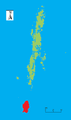 Outline map of the Andaman Islands, with the location of Little Andaman highlighted (in red).
 1990 Space Shuttle image of Little Andaman
References
- ↑ "Islandwise Area and Population - 2011 Census" (PDF). Government of Andaman.
- ↑ "Sailing Directions (enroute) | India and the Bay of Bengal" (PDF) (173). National Geospatial-intelligence Agency, United States Government. 2014. Retrieved 2016-09-23.
- ↑ "A&N Islands - Pincodes". 22 September 2016. Retrieved 22 September 2016.
- ↑ "STD Codes of Andaman and Nicobar". allcodesindia.in. Retrieved 2016-09-23.
- ↑ Registration Plate Numbers added to ISO Code
- ↑ "Village Code Directory: Andaman & Nicobar Islands" (PDF). Census of India. Retrieved 2011-01-16.
- ↑ "Government of India, Directorate General of Lighthouses and Lightships.". www.dgll.nic.in. Retrieved 2016-10-18.
- ↑ "DEMOGRAPHIC – A&N ISLANDS" (PDF). andssw1.and.nic.in. Retrieved 2016-09-23.
- ↑ guide
- ↑
| Wikimedia Commons has media related to Little Andaman. |
 Little Andaman travel guide from Wikivoyage