Little Lost River
| Little Lost River | |
| River | |
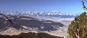 The Little Lost River Valley viewed from the west slope of the Lemhi Range | |
| Country | United States |
|---|---|
| State | Idaho |
| Tributaries | |
| - left | Sawmill Creek, Uncle Ike Creek |
| - right | Summit Creek, Wet Creek |
| City | Howe |
| Source | Confluence of Sawmill and Summit Creeks |
| - location | Upper Little Lost River Valley, Butte County |
| - elevation | 6,100 ft (1,859 m) |
| - coordinates | 44°11′14″N 113°16′45″W / 44.18722°N 113.27917°W |
| Mouth | Little Lost River Sinks |
| - location | Near Howe, Butte County |
| - elevation | 4,806 ft (1,465 m) |
| - coordinates | 43°45′52″N 112°58′22″W / 43.76444°N 112.97278°WCoordinates: 43°45′52″N 112°58′22″W / 43.76444°N 112.97278°W |
| Length | 49 mi (79 km), Northwest-southeast |
| Basin | 963 sq mi (2,494 km2) [1] |
| Discharge | |
| - average | 64.1 cu ft/s (2 m3/s) [2] |
| - max | 509 cu ft/s (14 m3/s) |
| - min | 3 cu ft/s (0 m3/s) |
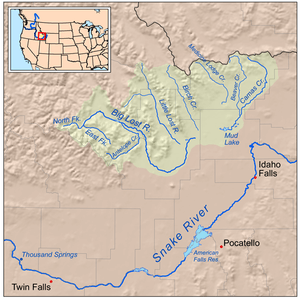 Map of the lost streams of Idaho including the Little Lost River | |
The Little Lost River is a river in the central part of the U.S. state of Idaho. The river is about 49 miles (79 km) long[3] and drains an arid farming valley, the Little Lost River Valley, bordered by the Lost River Range on the west and Lemhi Range on the east. Instead of emptying into a larger body of water, it disappears into the ground at the edge of the Snake River Plain, a phenomenon that gives it its name. The water feeds into the Snake River Aquifer, eventually reaching the Snake River through a series of springs farther west.
It rises at the confluence of two similarly sized streams, Summit Creek and Sawmill Creek, 10 miles (16 km) north of Hawley Mountain, in the middle of the Little Lost River Valley. The river flows generally south-southeast receiving many tributaries such as Wet (the largest), Badger, Deer, Uncle Ike, Sands, Cedarville, South, and Hurst creeks. Along its course the Little Lost is used for irrigation, but the only settlement of any size is Howe, situated near the mouth. A few miles past Howe, the river disappears into the earth at about 4,806 feet (1,465 m) above sea level.
The river drains about 963 square miles (2,490 km2) of land entirely in Butte County. Its valley is about 50 miles (80 km) long and 20 miles (32 km) wide, with a floor width of 7 miles (11 km). Precipitation is generally very low and mostly in the form of snow.
See also
References
- ↑ "Surface Water: Little Lost River Subbasin Assessment and Total Maximum Daily Loads". Idaho Department of Environmental Quality. Retrieved 2010-11-21.
- ↑ "USGS Gage #13118700 on the Big Lost River below Wet Creek, near Howe, ID" (PDF). National Water Information System. U.S. Geological Survey. 1958-present. Retrieved 2010-11-21. Check date values in:
|date=(help) - ↑ U.S. Geological Survey. National Hydrography Dataset high-resolution flowline data. The National Map, accessed May 4, 2011