Lost River Range
| Lost River Range | |
|---|---|
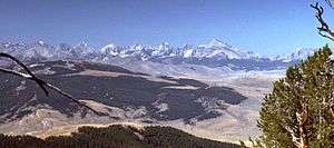 Lost River Range, looking southwest from the Lemhi Range | |
| Highest point | |
| Peak | Borah Peak |
| Elevation | 12,662 ft (3,859 m) |
| Coordinates | 44°08′15″N 113°46′52″W / 44.1373891°N 113.78110123°WCoordinates: 44°08′15″N 113°46′52″W / 44.1373891°N 113.78110123°W |
| Dimensions | |
| Length | 79 mi (127 km) N/S |
| Width | 67 mi (108 km) E/W |
| Area | 1,799 sq mi (4,660 km2) |
| Geography | |
| Country | United States |
| State | Idaho |
The Lost River Range is a high mountain range of the Rocky Mountains, located in central Idaho, in the northwestern United States.[1]
It runs southeast for approximately 75 miles (121 km) from the Salmon River near the community of Challis to the Snake River Valley near Arco. To the west are the valleys of the Salmon and the Big Lost Rivers, while to the east are the Little Lost River and Pashimeroi Valleys.
The range starts at the east bank of the Salmon River, at an elevation of about 5,000 feet (1,500 m). It quickly rises to Grouse Creek Mountain (11,085 ft, 3,378 m) and Dickey Peak (11,141 ft, 3,395 m), and then descends to Double Springs Pass, location of one of just two roads to cross the range. Nearby is an interpretive site explaining the effects of the magnitude 6.9 Borah Peak earthquake that hit the range on October 28, 1983. The Big Lost River Valley fell and the Lost River Range rose, leaving a fault scarp of up to 14 ft (4.3 m) along the base of the mountains.
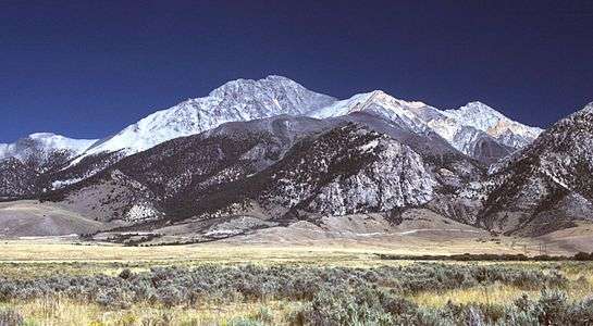
The range then rises into its high central section, which includes many of the state's highest peaks. Borah Peak, the highest, climbs to 12,662 ft (3,859 m). Further south are Mount Idaho (12,065 ft, 3,677 m), Leatherman Peak (12,228 ft, 3,727 m), Mount Church (over 12,200 ft, 3,720 m), Mount Breitenbach (12,140 ft, 3,700 m), and Lost River Mountain (12,078 ft, 3,681 m). To the east of this section of the range lie the remote canyons of the Upper Pashimeroi Valley, including scenic Merriam Lake.
The range then descends to Pass Creek Summit, the second road to cross its crest. It continues to King Mountain (10,612 ft, 3,235 m), a favorite site for hang gliders. Finally it descends sharply to the Snake River Valley near the community of Arco, at an elevation of 5,300 ft (1,600 m).
Peaks
References
- ↑ "Lost River Range". Geographic Names Information System. United States Geological Survey. Retrieved October 13, 2012.
- ↑ "Lost River Range". PeakBagger. Retrieved October 13, 2012.
External links
| Wikimedia Commons has media related to Lost River Range. |
- SummitPost.org: Lost River Range
- "Lost River Range". Peakbagger.com. Retrieved 2011-08-21.