Little White Salmon River
| Little White Salmon River | |
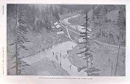 Fish hatchery and log flume, 1898 | |
| Country | United States |
|---|---|
| State | Washington |
| County | Skamania, Klickitat |
| Source | Monte Cristo Range of the Cascade Range |
| - location | Gifford Pinchot National Forest, Klickitat County |
| - elevation | 3,384 ft (1,031 m) [1] |
| - coordinates | 45°55′07″N 121°35′52″W / 45.91861°N 121.59778°W [2] |
| Mouth | Columbia River |
| - location | Drano Lake of the Bonneville Pool, Skamania County |
| - elevation | 98 ft (30 m) [2] |
| - coordinates | 45°43′14″N 121°38′25″W / 45.72056°N 121.64028°WCoordinates: 45°43′14″N 121°38′25″W / 45.72056°N 121.64028°W [2] |
| Length | 19 mi (31 km) [3] |
| Basin | 136 sq mi (352 km2) [4] |
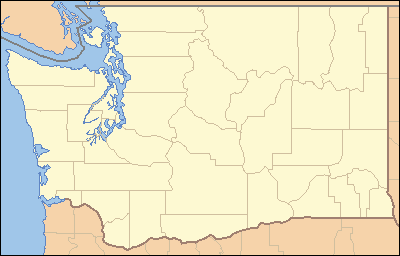 Location of the mouth of the Little White Salmon River in Washington | |
The Little White Salmon River is a tributary, about 19 miles (31 km) long,[3] of the Columbia River in the U.S. state of Washington. It headwaters are in the Monte Cristo Range in Gifford Pinchot National Forest. The river flows from this part of the Cascade Range into Drano Lake, an arm of the Bonneville Pool of the Columbia.[4] The river drains a basin of 136 square miles (350 km2)[4] The basin's population was an estimated 513 in 2000.[4]
Whitewater kayaking experts sometimes run a 4-mile (6.4 km) stretch of rapids in a steep canyon between the Cook–Underwood Road bridge and Drano Lake.[5] The run, dangerous throughout, is rated Class V (extremely difficult) on the International Scale of River Difficulty.[5] Named rapids include Gettin' Busy, Boulder Sluice, Island, Sacriledge, Double Drop, Backender, S-Turn, Wishbone, Bowey's Hotel, The Gorge, Stovepipe, Spirit Falls, Chaos and Master Blaster.[5] The river has been the scene of two kayaking deaths since this stretch was first run in the 1990s.[6]
Course
The Little White Salmon River begins in the Monte Cristo Range in western Klickitat County near its border with Skamania County. In its upper reaches, it flows generally south through the Gifford Pinchot National Forest before turning southwest, receiving Beetle Creek from the right and entering Skamania County. Downstream of the county border, it passes through Oklahoma Campground and under Oklahoma Road (Forest Road 18), which then runs along the right. In the next stretch, the river receives Homes Creek from the left and Lusk Creek from the right.[7]
Turning more sharply south, the river receives Berry Creek from the right, then passes under Oklahoma Road again before Cabbage Creek enters from the right. The road now runs along the left bank of the river as it meanders along the base of Shingle Mountain, which is to the river's right. In this stretch, Wilson Creek enters from the left before the river reaches Big Cedars County Park. Below the park, the river passes under Oklahoma Road again before flowing by Moss Creek Campground, on the river's right along the road. Below camp, Moss Creek enters from the right.[7]
Over the next stretch, the river reaches the community of Willard and leaves the national forest. Just below Willard, the river passes under Willard Road, and Pine Creek enters from the right. Slightly further downstream, the Little White Salmon passes the Willard National Fish Hatchery, on the right, flows under Cook–Underwood Road, enters the Columbia River Gorge National Scenic Area, and receives Lapham Creek from the left. In a narrow canyon paralleled by Cook–Underwood Road on both sides of the river for the next stretch, the stream receives Rock, Squaw, and Bunker creeks, all from the right. At the end of the canyon, the river passes through the Little White Salmon National Fish Hatchery and enters Drano Lake, 163 miles (262 km) from the Columbia's mouth on the Pacific Ocean.[7]
Campgrounds
The United States Forest Service operates the Oklahoma Campground along upper Little White Salmon River. Amenities include 22 campsites, vault toilets, and potable water.[8] The Lower Monte Carlo Trailhead is across Oklahoma Road (Forest Road 18) from the campground.[9]
Further downstream, Skamania County manages the Big Cedars Campground, with two sites for tents and another for a small motorized camper.[10] Near the county park and on the opposite side of Oklahoma Road is Moss Creek Campground, run by the Forest Service. Amenities include potable water, vault toilets, and 17 campsites.[11]
See also
References
- ↑ Source elevation derived from Google Earth search using GNIS source coordinates.
- 1 2 3 "Little White Salmon River". Geographic Names Information System. United States Geological Survey. September 10, 1979. Retrieved January 29, 2013. Source coordinates adjusted slightly with Google Earth.
- 1 2 Washington Department of Wildlife; et al. (September 1, 1990). "Little White Salmon River Subbasin Salmon and Steelhead Production Plan" (PDF). Streamnet Library. United States Geological Survey. p. 5. Retrieved January 29, 2013..
- 1 2 3 4 "Volume II, Chapter 17: Little White Salmon Subbasin" (PDF). Northwest Power and Conservation Council. 2004. p. 1 (section 17). Retrieved January 29, 2013.
- 1 2 3 Giordano, Pete (2004). Soggy Sneakers: A Paddler's Guide to Oregon's Rivers (4th ed.). Seattle: The Mountaineers Books. pp. 265–66. ISBN 978-0-89886-815-9.
- ↑ Davidson, Nick (June 26, 2012). "Kayaker Dies on the Little White Salmon". Outside Online. Mariah Media Network. Retrieved January 29, 2013.
- 1 2 3 United States Geological Survey. "United States Topographic Map". TopoQuest. Retrieved January 29, 2013.
- ↑ "Oklahoma Campground". United States Forest Service. Retrieved January 30, 2013.
- ↑ "Trailhead: Monte Carlo-Lower". United States Forest Service. Retrieved January 30, 2013.
- ↑ "Big Cedars Campground". Skamania County. Retrieved January 30, 2013.
- ↑ "Moss Creek Campground". United States Forest Service. Retrieved January 30, 2013.
External links
![]() Media related to Little White Salmon River at Wikimedia Commons
Media related to Little White Salmon River at Wikimedia Commons