Livingston, Guatemala
| Livingston | |
|---|---|
|
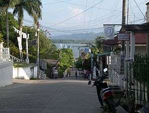
Livingston main street | |
 Livingston Location in Guatemala | |
| Coordinates: 15°49′48″N 88°45′00″W / 15.83000°N 88.75000°W | |
| Country |
|
| Department | Izabal Department |
| Climate | Af |
Livingston is the name of a town in Izabal Department, eastern Guatemala, at the mouth of the Río Dulce at the Gulf of Honduras. The town serves as the municipal seat of the municipality of the same name. It was Guatemala's main port on the Caribbean Sea before the construction of nearby Puerto Barrios.
Livingston is noted for its unusual mix of Garífuna, Afro-Caribbean, Maya and Ladino people and culture. In recent decades Livingston has developed a large tourist industry.
History
Livingston is named after American jurist and politician Edward Livingston who wrote the Livingston Codes which - translated into Spanish by liberal leader José Francisco Barrundia - were used as the basis for the laws of the liberal government of the United Provinces of Central America in the early 19th century. This government did not came to fruition in Guatemala, however, because of the conservative and clerical revolution led by Rafael Carrera in 1838 that overthrew governor Mariano Galvez and gave way to a conservative and Catholic regime that lasted until 1871 in Guatemala.[1]
Franja Transversal del Norte
In the 1960s, the importance of the region known as Franja Transversal del Norte was in livestock, exploitation of precious export wood and archaeological wealth. Timber contracts we granted to multinational companies such as Murphy Pacific Corporation from California, which invested US$30 million for the colonization of southern Petén and Alta Verapaz, and formed the North Impulsadora Company. Colonization of the area was made through a process by which inhospitable areas of the Franja Transversal del Norte (FTN) were granted to native peasants.[2]
In 1964, the National Institute for Agrarian Transformation (INTA) defined the geography of the FTN as the northern part of the departments of Huehuetenango, Quiché , Alta Verapaz and Izabal and that same year priests of the Maryknoll order and the Order of the Sacred Heart began the first process of colonization, along with INTA, carrying settlers from Huehuetenango to the Ixcán sector in Quiché.[3]
The Northern Transversal Strip was officially created during the government of General Carlos Arana Osorio in 1970, by Decree 60-70 in the Congress, for agricultural development.[4] The area included within the municipalities: San Ana Huista, San Antonio Huista, Nentón, Jacaltenango, San Mateo Ixtatán, and Santa Cruz Barillas in Huehuetenango; Chajul and San Miguel Uspantán in Quiché; Cobán, Chisec, San Pedro Carchá, Lanquín, Senahú, Cahabón and Chahal, in Alta Verapaz and the entire department of Izabal.[5]
Economy
African oil palm

There is a large demand within Guatemala and some of its neighbors for edible oils and fats, which would explain how the African oil palm became so prevalent in the country in detriment of other oils, and which has allowed new companies associated to large capitals in a new investment phase that can be found particularly in some territories that form the Northern Transversal Strip of Guatemala.[7] The investors are trying to turn Guatemala into one of the main palm oil exporters, in spite of the decline on its international price. The most active region is found in Chisec and Cobán, in Alta Verapaz Department; Ixcán in Quiché Department, and Sayaxché, Petén Department, where Palmas del Ixcán, S.A. (PALIX) is located, both with its own plantation and those of subcontractors. Another active region is that of Fray Bartolomé de las Casas and Chahal in Alta Verapaz Department; El Estor and Livingston, Izabal Department; and San Luis, Petén, where Naturaceites operates.[7]
Transport
Boats run several times a day from Puerto Barrios, and twice a week on Tuesdays and Fridays from Punta Gorda, Belize. Boats also run every morning from Livingston to Punta Gorda. However, due to collusion between boat owners, the fares are much higher than passage from Puerto Barrios. There is another boat that transports tourists from Livingston in through Río Dulce; it runs every day. All access is via watercraft since there is no road link to the rest of Guatemala.
As of early 2014, foreign passengers arriving in Livingston still present their passports at the customs office, which is two blocks up the hill from the dock, on the left side of the street. One is entirely free to walk right past the customs office and forego this formality; however, doing so may subject one to significant delays and possible fines when one leaves Guatemala at any land crossing, port, or airport.
Languages
A number of languages are spoken in Livingston including Spanish, Garifuna language, Mayan Q'eqchi', and English.
Notable people
- Guillermo Ramírez, soccer player of Municipal, C.S.D. in the Guatemalan Soccer League
- Marvin Avila, soccer player of Shaanxi Neo-China Chanba F.C.
- Ricardo Trigueño Foster, soccer player of Deportivo Petapa in the Guatemalan Soccer League.
In films
The New Adventures of Tarzan' (1935)

In 1935, the film The New Adventures of Tarzan, was filmed on location in Guatemala, taking advantage of the help from the United Fruit Company and president Jorge Ubico. The places where the filming was made were:
- Chichicastenango: scenes of a native town where the explorers first met.[8]
- Antigua Guatemala: The Green Goddess temple
- Livingston: scenes where explorers prepare to go into the jungle
- Puerto Barrios: arrival and departure of the boats carrying the explorers
- Tikal: jungle scenes
- Quiriguá: Mayan city where they get lectured on the maya civilization
- Guatemala City: then luxurious Palace Hotel was used to shoot the scenes of the hotel in the imaginary town of At Mantique[8]
Climate
Livingston has a tropical rainforest climate (Köppen: Af).
| Climate data for Livingston | |||||||||||||
|---|---|---|---|---|---|---|---|---|---|---|---|---|---|
| Month | Jan | Feb | Mar | Apr | May | Jun | Jul | Aug | Sep | Oct | Nov | Dec | Year |
| Daily mean °C (°F) | 23.7 (74.7) |
24.5 (76.1) |
26.0 (78.8) |
27.4 (81.3) |
28.0 (82.4) |
28.0 (82.4) |
27.6 (81.7) |
27.7 (81.9) |
27.6 (81.7) |
26.6 (79.9) |
25.0 (77) |
24.1 (75.4) |
26.35 (79.44) |
| Average precipitation mm (inches) | 212 (8.35) |
125 (4.92) |
105 (4.13) |
131 (5.16) |
202 (7.95) |
433 (17.05) |
621 (24.45) |
486 (19.13) |
431 (16.97) |
346 (13.62) |
313 (12.32) |
231 (9.09) |
3,636 (143.14) |
| Source: Climate-Data.org[9] | |||||||||||||
Geographic location
 |
Belice | | ||
| Chahal and Cahabón, municipalities of Alta Verapaz Department | |
Lago de Izabal, Río Dulce and Puerto Barrios, municipality of Izabal Department[10] | ||
| ||||
| | ||||
| El Estor, municipality of Izabal Department[10] | Lago de Izabal |
See also
-
 Guatemala portal
 -
 Geography portal
 - Belice
- Edward Livingston
- Mariano Gálvez
- Río Dulce
- List of places in Guatemala
Notes and references
References
- ↑ González Davison, Fernando (2008). La montaña infinita; Carrera, caudillo de Guatemala (in Spanish). Guatemala: Artemis y Edinter. ISBN 84-89452-81-4.
- ↑ Solano 2012, p. 12.
- ↑ Solano 2012, p. 13.
- ↑ "Franja Transversal del Norte". Wikiguate. Retrieved 30 October 2014.
- ↑ Solano 2012, p. 15.
- ↑ Solano 15 July 2015, p. 6.
- 1 2 Solano 15 July 2015, p. 1
- 1 2 Barillas, Edgar (2013). "50 películas filmadas en Guatemala y una que no (1935-1996). Apuntes para una cartografía de los lugares filmados en Guatemala". Revista Historia de la Universidad de San Carlos de Guatemala (in Spanish). Guatemala. Archived from the original on October 22, 2015. Retrieved 22 October 2015.
- ↑ "Climate:Livingston". Climate-Data.org. Retrieved 19 August 2015.
- 1 2 SEGEPLAN (n.d.). "Municipios de Izabal, Guatemala". Secretaría General de Planificación (in Spanish). Archived from the original on 5 July 2015. Retrieved 5 July 2015.
Bibliography
- Solano, Luis (2012). Contextualización histórica de la Franja Transversal del Norte (FTN) (PDF) (in Spanish). Centro de Estudios y Documentación de la Frontera Occidental de Guatemala, CEDFOG. Archived from the original (PDF) on 13 November 2014. Retrieved 31 October 2014.
- Solano, Luis (15 July 2015). "Palma Africana" (PDF). Revista Enfoque (in Spanish). Guatemala (36). Archived from the original (PDF) on 19 July 2015. Retrieved 19 July 2015.
External links
 Livingston (Guatemala) travel guide from Wikivoyage
Capital: Puerto Barrios | ||
| Municipalities | 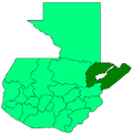 | |
| Departaments in the region | ||
|---|---|---|
| Major rivers and lakes | ||
| International corporation in the area | ||
| Civil War events | ||
| Presidents of Guatemala related to the region | ||
Coordinates: 15°49′48″N 88°45′00″W / 15.83000°N 88.75000°W