Louisiana Highway 112
| ||||
|---|---|---|---|---|
 | ||||
| Route information | ||||
| Maintained by Louisiana DOTD | ||||
| Length: | 80.9 mi[1] (130.2 km) | |||
| Existed: | 1955 renumbering – present | |||
| Major junctions | ||||
| West end: |
| |||
|
| ||||
| East end: |
| |||
| Location | ||||
| Parishes: | Beauregard, Allen, Rapides | |||
| Highway system | ||||
| ||||
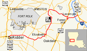
Louisiana Highway 112 (LA 112) is a state highway in Louisiana. It spans 80.9 miles (130.2 km) and runs from west to east. LA 112 is a mostly rural two lane highway with a maximum speed limit of 55 miles per hour (89 km/h) per hour. The western terminus is at an intersection with U.S. Route 171/U.S. Route 190 in Beauregard Parish and the eastern terminus at an intersection with US 167/US 71 in Rapides Parish. Although the highway runs west to east it meanders through three parishes and on the map appears to make a large S.
Route description
Beginning at the western terminus LA 112 travels northeast and intersects with LA 113 in Sugartown, enters Allen Parish, and merges running concurrent a short distance with LA 377. LA 113 then intersects with LA 1156, and into Elizabeth, intersecting and running concurrent with LA 10 east a short distance. LA 10 splits continuing east while LA 112 turns north, enters Rapides Parish, merges with LA 113 again at Union Hill. LA 112 swings northwest then north and merges running concurrent with LA 121, intersecting LA 461, and splitting in Hineston. LA 121 continues north to intersect with LA 28 and LA 112 resumes an eastern route, passing through the community of Lisso, intersecting LA 488 then LA 1199, and passes through the communities of Elmer and Melder before intersecting and merging with U.S. 165 south into Forest Hill. LA 112 swings east then northeast, like a large check mark, before resuming an eastern route, passing through the community of Midway, and intersecting Interstate 49, before terminating in Lecompte at an intersection with U.S. 167/ U.S. 71.
History
LA 112 is an old historic route that traverses through what was once some fairly large sawmill towns. The meandering of the highway through the parishes served, to provide a link to the communities, was also necessitated by the need to cross large creeks and rivers at the best location.
Major intersections
| Parish | Location | mi | km | Destinations | Notes |
|---|---|---|---|---|---|
| Beauregard | | 0.0 | 0.0 | Western terminus | |
| | 1.8 | 2.9 | Southern terminus of LA 1146 | ||
| | 10.5 | 16.9 | Southern terminus of LA 399 | ||
| Sugartown | 15.1 | 24.3 | |||
| Allen | | 20.4 | 32.8 | West end of LA 377 concurrency | |
| | 23.3 | 37.5 | East end of LA 377 concurrency | ||
| Elizabeth | 30.4 | 48.9 | Northern terminus of LA 1156 | ||
| | 30.8 | 49.6 | West end of LA 10 concurrency | ||
| Elizabeth | 32.0 | 51.5 | Northern terminus of LA 3206; east end of LA 10 concurrency | ||
| Rapides | | 36.1 | 58.1 | ||
| Union Hill | 41.2 | 66.3 | |||
| | 52.0 | 83.7 | West end of LA 121 concurrency | ||
| | 52.7 | 84.8 | Northern terminus of LA 461 | ||
| Hineston | 53.4 | 85.9 | East end of LA 121 concurrency | ||
| | 56.8 | 91.4 | Southern terminus of LA 488 | ||
| Elmer | 58.1 | 93.5 | Southern terminus of LA 1199 | ||
| | 68.1 | 109.6 | Northern terminus of LA 497 | ||
| Bringhurst | 69.3 | 111.5 | West end of US 165 concurrency | ||
| Forest Hill | 71.3 | 114.7 | West end of LA 497 concurrency | ||
| 71.5 | 115.1 | East end of US 165 concurrency | |||
| 71.6 | 115.2 | East end of LA 497 concurrency | |||
| | 78.1– 78.3 | 125.7– 126.0 | Exit 66 on I-49 | ||
| Lecompte | 80.7 | 129.9 | |||
| 80.9 | 130.2 | Eastern terminus | |||
1.000 mi = 1.609 km; 1.000 km = 0.621 mi
| |||||
References
- ↑ Google (January 27, 2015). "Louisiana Highway 112" (Map). Google Maps. Google. Retrieved January 27, 2015.
.svg.png)