Low Fulney

Coordinates: 52°46′44″N 0°07′19″E / 52.778985°N 0.12187°E
Low Fulney is a hamlet in the South Holland district of Lincolnshire, England. The population is included in the Spalding St. Paul's ward of the South Holland District Council. It is situated 1.5 miles (2.4 km) east from the town of Spalding,
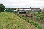
Fulney Lock, Spalding
Thornholme Grange, a house of 15th-century origin, was built of brick on the supposed site of Spalding Priory dairy. It was extended and partially rebuilt in the 16th century. It was altered in the 19th century, and again in 1936 when acquired by the Land Settlement Association.[1]
References
- ↑ Historic England. "Low Fulney (916111)". PastScape. Retrieved 10 July 2011.
External links
 Media related to Low Fulney at Wikimedia Commons
England Portal | |
| Unitary authorities | |
| Boroughs or districts | |
| Major settlements |
|
| Topics | |
This article is issued from Wikipedia - version of the 5/23/2016. The text is available under the Creative Commons Attribution/Share Alike but additional terms may apply for the media files.