Lubang Island
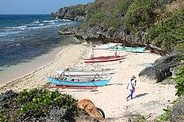 One of the beaches in Lubang island | |
.svg.png) Lubang Island Location within the Philippines | |
| Geography | |
|---|---|
| Coordinates | 13°46′3″N 120°11′10″E / 13.76750°N 120.18611°ECoordinates: 13°46′3″N 120°11′10″E / 13.76750°N 120.18611°E |
| Archipelago | Lubang Group of Islands |
| Adjacent bodies of water | |
| Administration | |
| Region | MIMAROPA |
| Province | Occidental Mindoro |
| Municipalities | |
Lubang Island is the largest island in the Lubang Group of Islands, an archipelago which lies to the northwest of the northern end of Mindoro in the Philippines. The Lubang Islands are about 150 kilometres (93 mi) southwest of Manila. There are seven islands in the group,[1] The island is divided into two municipalities. The largest settlement is the town of Lubang, the northwest end of the island. Its town center is about 8 miles (13 km) northwest of Tilik Port, the only safe anchorage on Lubang Island.[2] The southeastern half of the island is covered by the Municipality of Looc.
Geography
Northwest to southeast the four main islands are Cabra Island, separated by a deep, 3-kilometre (1.9 mi) wide channel from Lubang Island, then Ambil Island and finally Golo Island. The three smaller islands are Talinas Island, Malavatuan Island and Mandaui Island.[1]
- Cabra Island is mostly wooded and about 3 kilometres (1.9 mi) long, rising to a height of about 60 metres (200 ft). It has a lighthouse at the northwest end of the island.[1][2]
- Lubang Island is about 125 square kilometres (48 sq mi), being over 25 kilometres (16 mi) in length and up to 10 kilometres (6.2 mi) wide.[1]
- Ambil Island is an extinct volcanic island rising to over 760 metres (2,490 ft) and is about 26 square kilometres (10 sq mi) in area.[1] During the earlier part of the Spanish Colonial Era, Ambil was reported to be in eruption.[3] But when it was climbed by German scientist Carl Semper in the latter part of 19th century, he found no evidence that it has erupted in historical times.[4]
- Golo Island is long, narrow and flat lying, and is about 26 square kilometres (10 sq mi) in area.[1]
History
The islands were originally settled by an ethnic group from the Visayan. By 1900 the islands were inhabited by both Tagalog and Visayan people.[1]
The Spanish built a fort on Lubang Island, the San Vicente Bastion, on the western point of the entrance to Tilik Port.
After World War II, Lubang Island was where Hiroo Onoda, a Japanese army intelligence officer, hid in the jungles when the Allies reclaimed the Philippines. He engaged in continuous, and sometimes deadly, guerrilla warfare against the United States and later against Philippine Commonwealth troops and paramilitary police. Despite flyers being dropped by airplanes in his hiding area, he adamantly believed that the war was not over yet. In March 1974, he was officially relieved of duty, 29 years after the end of the war, making him one of the last Japanese soldiers to surrender. [5] An independent documentary titled Search For Onoda is currently in production. The documentary was shot on location around Vigo, Burol, Ackawayan and Looc.[6]
Marian Apparitions
From 1966 to 1972, a much-publicized series of Marian apparitions reportedly occurred on the island of Cabra, an impoverished and barren island-barangay of Lubang. The "beautiful lady in white, with a blue sash around her waist" who wanted to be called "Immaculada Concepcion," repeatedly urged the girls, led by honor student Belinda Villas, to pray for those who persist to malign and sin against the Lord and to have a chapel erected in Burol, a rocky promontory overlooking Libis, the shoreline where boats from the Lubang poblacion usually dock. Remarkably, the Lady spoke in the Tagalog vernacular of the island. The film Himala by Ishmael Bernal was allegedly based on these apparitions, but this claim is at the very least preposterous and untrue. The film's plot and characters did not accurately, or even remotely, depict the story and messages of the apparitions, let alone present the seers' individual biographies. They were never interviewed, and even their copious notes written after each encounter on the hill were neither read nor seen by its writer and director. Mrs. Juana V. Torreliza, the late principal of Cabra Elementary School, served as the girls' de facto defender, mentor, and, oftentimes, spokesperson. Tim Albano, the founder of the now-defunct charity high school on the island (Magnificat Academy Foundation - 1977-1981), personally financed the painstaking research work behind, and the publication of, the book The Apparitions of Cabra Islet. Copies of this book can be found in the libraries of many Catholic colleges and schools, both in the Philippines and the United States, including the National Library of the Philippines and the U.S. Library of Congress. Many avid devotees of the Beautiful Lady on the hill of Burol have been urging the Catholic Church to initiate a rigorous examination and investigation of these apparitions. They also hope that Mr. Albano, or his heirs or friends, will soon come around to publishing the book's chapters and photographs preferably in widely-disseminated online blogs. They also proposed scanning the whole book for Google Books, or perhaps even reprinting it for the new generations. The tiny chapel on the Apparition hill has been sadly neglected and is now badly dilapidated, its tin roof rusting and leaking, and its walls and windows decrepit and crumbling. The girls/seers became nurses and midwives, and they have successfully maintained their anonymity. They are now residing in far-flung provinces and countries.

Administration
The islands are administratively part of the province of Occidental Mindoro and are divided into two municipalities: Lubang and Looc. Lubang covers the northwestern half of Lubang Island (Cabra Island included), while Looc covers the remaining half of Lubang Island plus Ambil, Golo and the other islands. Looc Proper is divided into three major sections: BonBon, Gitna and Kanluran. These islands offer scenic delights, pristine waters, abundant and precious marine life, and scuba-diving opportunities. The coast lines boasts of white sand and unspoiled beauty.
Economics
Most of the population resides on Lubang Island, where Tilik Port is located. The main economic activity is fishing in the waters surrounding the islands and planting rice, garlic, peanut and vegetables. However, with the islands fine white-sand coastlines, tourism is growing in economic importance.
Notes
- 1 2 3 4 5 6 7 Landor, Arnold Henry Savage (1904). The Gems of the East: Sixteen Thousand Miles of Research Travel Among Wild and Tame Tribes of Enchanting Islands, p. 10. Harper & Bros., New York. OCLC 1688191
- 1 2 Dow, John C. (1906). Philippine Islands Sailing Directions: Section II: Southwest and South Coasts of Luzon and Adjacent Islands from Manila to San Bernardino Straits (third edition), pp 19-20. U.S. Coast and Geodetic Survey, Manila.
- ↑ Daubeny, Charles (1848). "A description of active and extinct volcanos, of earthquakes, and of thermal springs", p.399. Richard and John E. Taylor, London.
- ↑ Becker, George F. (1901). "Report of the Geology of the Philippines", p.53. Government Printing Office, Wachington.
- ↑ Trefalt, Beatrice (1999) "A Straggler Returns: Onoda Hirō and Japanese Memories of the War" War & Society 17(2): pp. 111–124, doi:10.1179/072924799791201470
- ↑ http://searchforonoda.com
References
- Hiroo Onoda (1974) No Surrender: My Thirty-Year War Kodansha International, New York, ISBN 0-87011-240-6