Lublin Voivodeship (1919–39)
| Lublin Voivodeship Wojewodztwo lubelskie | |||||
| Voivodeship of Poland | |||||
| |||||
|
Coat of arms | |||||
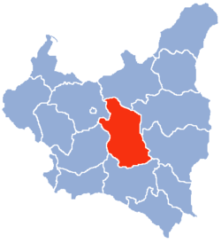 within the Second Polish Republic, 1938. | |||||
| Capital | Lublin | ||||
| Government | Voivodeship | ||||
| Voivode | |||||
| • | 1919–1926 | Stanisław Moskalewski | |||
| • | 1937–1939 | Jerzy Albin de Tramecourt | |||
| History | |||||
| • | Established | 14 August 1919 | |||
| • | Terrtiorial changes | 1 April 1938 | |||
| • | Annexed by Germany | September 1939 | |||
| Area | |||||
| • | 1921 | 31,123 km2 (12,017 sq mi) | |||
| • | 1939 | 26,555 km2 (10,253 sq mi) | |||
| Population | |||||
| • | 1921 | 2,087,951 | |||
| Density | 67.1 /km2 (173.8 /sq mi) | ||||
| • | 1931 | 2,116,200 | |||
| Political subdivisions | 16 powiats, 29 cities | ||||

Lublin Voivodeship (Polish: Województwo Lubelskie) was a unit of administrative division of the Second Polish Republic between the two world wars, in the years 1919–1939. The province's capital and biggest city was Lublin.
Location and area
The Voivodeship was founded by the decree of Polish Parliament Sejm of 14 August 1919.[1] In the years 1919–1939 (unlike today), Lublin Voivodeship covered the central part of interwar Poland – the heartland of the country – bordering Białystok Voivodeship (1919–39) to the north, Warsaw Voivodeship and Kielce Voivodeship to the west, Lwów Voivodeship to the south and Polesie Voivodeship as well as Volhynian Voivodeship to the east. Its area, after April 1, 1938 (see: Territorial changes of Polish Voivodeships on April 1, 1938) was 26,555 km². Landscape was flat and hilly in the south, forests covered only 16.6% of the area (with nation's average of 22.2%, as for January 1, 1937).
Demographics
According to the Polish census of 1921 which was the First General Census in the Second Polish Republic following World War One (conducted by the Main Bureau of Statistics, see originals),[2] the population of Lublin Voivodeship could be categorized by both location and religious beliefs in the following way.[2][3]
| # | County | Roman Catholic | Eastern Orthodox | Jewish | Other |
|---|---|---|---|---|---|
| 1 | Biała | 37,239 (62.6%) | 9,551 (16%) | 11 550 (19.4%) | 1 180 (2%) |
| 2 | Biłgoraj | 65,889 (72.4%) | 15,883 (17.5%) | 9,056 (9.9%) | 188 (0.2%) |
| 3 | Chełm | 68,770 (56.6%) | 24,701 (20.3%) | 19,912 (16.4%) | 8,092 (6.7%) |
| 4 | Garwolin | 117,391 (85.2%) | 126 (0.1%) | 17,772 (12.9%) | 2,488 (1.8%) |
| 5 | Hrubieszów | 50,735 (48.9%) | 38,468 (37%) | 13,967 (13.5%) | 671 (0.6%) |
| 6 | Janów | 117,368 (89.3%) | 697 (0.5%) | 13,407 (10.2%) | 30 (0.02%) |
| 7 | Konstantynów | 53,667 (82.5%) | 4,012 (6.2%) | 7,241 (11.1%) | 135 (0.2%) |
| 8 | Krasnystaw | 102,016 (87.1%) | 4,149 (3.5%) | 10,493 (9.0%) | 422 (0.4%) |
| 9 | Lubartów | 83,732 (87%) | 1,197 (1.2%) | 9,669 (10%) | 1,645 (1.7%) |
| 10 | Lublin (city) | 55,610 (58.9%) | 514 (0.5%) | 37,337 (39.5%) | 951 (1%) |
| 11 | Lublin (distr.) | 128,303 (91.7%) | 910 (0.7%) | 9,608 (6.9%) | 1,079 (0.8%) |
| 12 | Łuków | 107,604 (87.3%) | 932 (0.8%) | 14,185 (11.5%) | 552 (0.4%) |
| 13 | Puławy | 129,281 (86.8%) | 206 (0.1%) | 19,296 (12.9%) | 238 (0.2%) |
| 14 | Radzyń | 70,976 (80.3%) | 1,862 (2.1%) | 14,765 (16.7%) | 778 (0.9%) |
| 15 | Siedlce | 76,446 (77.6%) | 851 (0.9%) | 18,821 (19.1%) | 2,345 (2.4%) |
| 16 | Sokołów | 67,224 (88.4%) | 420 (0.6%) | 8,294 (10.9%) | 141 (0.2%) |
| 17 | Tomaszów | 57,869 (62.4%) | 22,389 (24.1%) | 12,154 (13.1%) | 397 (0.4%) |
| 18 | Węgrów | 68,985 (83.3%) | 185 (0.2%) | 9,325 (11.3%) | 4,277 (5.2%) |
| 19 | Włodawa | 40,881 (53.3%) | 20,104 (26.2%) | 13,562 (17.7%) | 2,171 (2.8%) |
| 20 | Zamość | 119,769 (84%) | 5,441 (3.8%) | 17,225 (12.1%) | 179 (0.1%) |
| TOTAL | 1,619,755 (77.6%) | 152,598 (7.3%) | 287,639 (13.8%) | 27,959 (1.3%) | |
Population breakdown by religious denomination in the 1931 national census:[3]
| # | County | Roman Catholic | Eastern Orthodox | Jewish | Other |
|---|---|---|---|---|---|
| 1 | Biała | 82,647 (71.1%) | 18,192 (15.6%) | 14,288 (12.3%) | 1,139 (1%) |
| 2 | Biłgoraj | 82,614 (70.6%) | 20,913 (17.9%) | 12,938 (11.1%) | 486 (0.4%) |
| 3 | Chełm | 88,488 (54.5%) | 37,530 (23.1%) | 22,852 (14.1%) | 13,470 (8.3%) |
| 4 | Garwolin | 139,128 (87%) | 67 | 18,741 (11.7%) | 2,006 (1.3%) |
| 5 | Hrubieszów | 63,365 (48.8%) | 49,128 (37.8%) | 15 785 (12.1%) | 1,679 (1.3%) |
| 6 | Janów | 135,182 (88.5%) | 1,159 (0.8%) | 15,317 (10%) | 1,060 (0.7%) |
| 7 | Krasnystaw | 113,442 (84.6%) | 4,853 (3.6%) | 12,127 (9.0%) | 3,737 (2.8%) |
| 8 | Lubartów | 94,356 (87.4%) | 1,544 (1.4%) | 9,652 (8.9%) | 2,439 (2.3%) |
| 9 | Lublin (city) | 71,542 (63.7%) | 703 (0.6%) | 38,937 (34.7) | 1103 (1%) |
| 10 | Lublin (distr.) | 149,192 (91.2%) | 125 (0.1%) | 12,049 (7.4%) | 2,136 (1.3%) |
| 11 | Łuków | 113,549 (88%) | 76 | 14,736 (11.4%) | 722 (0.6%) |
| 12 | Puławy | 149,060 (86.5%) | 182 (0.1%) | 21,949 (12.7%) | 1,076 (0.6%) |
| 13 | Radzyń | 80,520 (81.3%) | 1,840 (1.9%) | 15,548 (15.7%) | 1,181 (1.2%) |
| 14 | Siedlce | 125,018 (82.6%) | 657 (0.4%) | 23,069 (15.2%) | 2,667 (1.8%) |
| 15 | Sokołów | 74,941 (89.3%) | 145 (0.2%) | 8,334 (9.9%) | 529 (0.6%) |
| 16 | Tomaszów | 73,021 (60.3%) | 33,059 (27.3%) | 14,204 (11.7%) | 840 (0.7%) |
| 17 | Węgrów | 76,511 (86.2%) | 40 | 8,888 (10%) | 3,349 (3.8%) |
| 18 | Włodawa | 57,939 (51%) | 33,382 (29.4%) | 18,188 (16%) | 4,057 (3.6%) |
| 19 | Zamość | 125,249 (83.8%) | 6,778 (4.5%) | 16,738 (11.2%) | 783 (0.5%) |
| TOTAL | 1,895,764 (76.9%) | 210,373 (8.5%) | 314,340 (12.7%) | 44,459 (1.8%) | |
Ethnic groups
According to the 1931 Polish census, the population was 2,116,200. Poles made up 85.1% of population, Jews 10.5%, and Ukrainians (in the east and south) 3%. The Jews preferred to live in the cities and towns, especially in Lublin itself.
Due to ruthless Russification policies throughout the preceding century leading to general absence of schools in the Voivodeship, 24.6% of population was still illiterate as of 1931, although rapidly decreasing from 46.8% in 1921.[3][2]
Industry
The Voivodeship's biggest industrial center was the city of Lublin. Other than that, it lacked significant industry centers. In mid-1930s Polish government started a huge public works program, called Centralny Okręg Przemysłowy, which was a great boost to overpopulated and poor counties. It covered southwestern part of the Voivodeship, with the town of Kraśnik. The railroad density was 4.0 km. per 100 km². (with total length of railroads 1 236 km.).
Cities and administrative divisions
Lublin Voivodeship in mid-1939 consisted of 16 powiats (counties) 29 cities and towns and 228 villages. The counties were:
- Biała Podlaska county (area 2,122 km², population 116,000)
- Biłgoraj county (area 1,720 km², population 116,900)
- Chełm county (area 1,975 km², population 162,300)
- Hrubieszów county (area 1,575 km², population 130,000)
- Janów Lubelski county (area 1,960 km², population 152,700)
- Krasnystaw county (area 1,521 km², population 134,200)
- Lubartów county (area 1,389 km², population 108,000)
- City of Lublin county (area 30 km², population 112,300)
- Lublin county (area 1,889 km², population 163,500)
- Łuków county (area 1,762 km², population 129,100)
- Puławy county (area 1,618 km², population 156,500)
- Radzyń Podlaski county (area 1,621 km², population 99,100)
- Siedlce county (area 1,988 km², population 151,400)
- Tomaszów Lubelski county (area 1,397 km², population 121,100)
- Włodawa county (area 2,326 km², population 113,600)
- Zamość county (area 1,662 km², population 149,500)
According to the 1931 census, biggest cities were:
- Lublin (pop. 112,300)
- Siedlce (pop. 36,900)
- Chełm (pop. 29,100)
- Zamość (pop. 24,700)
- Biała Podlaska (pop. 17,400)
- Miedzyrzec Podlaski (pop. 16,800)
- Łuków (pop. 14,000)
- Hrubieszów (pop. 13,200)
- Kraśnik (pop. 12,200)
- Puławy (pop. 12,100)
Voivodes
- Stanisław Moskalewski, 17 November 1919 – 25 October 1926
- Antoni Remiszewski, 3 November 1926 – 29 September 1930
- Bolesław Świdziński, 29 September 1930 – 30 January 1933 (acting till 1 April 1932)
- Józef Rożniecki, 31 January 1933 – 8 September 1937
- Jerzy Albin de Tramecourt, 8 September 1937 – 17 September 1939
See also
- Poland's modern-day Lublin Voivodeship
References
- ↑ Act of Polish Parliament Sejm (2 August 1919), Dz. U. z 1919 r. Nr 65, poz. 395. Internetowy System Aktow Prawnych. Retrieved 25 October 2015.
- 1 2 3
 Media related to Polish census of 1921 - Statistics of Poland at Wikimedia Commons; vol. 18: Województwo Lubelskie (PDF), pp. 35–73.
 - 1 2 3 Konrad Sadkowski (1995), Church, Nation and State in Poland: Catholicism and National Identity Formation in the Lublin Region, 1918–1939. University of Michigan, pp. 85–86. [ISBN needed]
- Maly rocznik statystyczny 1939, Nakladem Glownego Urzedu Statystycznego, Warszawa 1939 (Concise Statistical Year-Book of Poland, Warsaw 1939).
| City Voivodeship |  | |
|---|---|---|
| Land Voivodeships | ||
| Planned Voivodeships | ||
Coordinates: 51°14′00″N 22°34′00″E / 51.233333°N 22.566667°E