Lusia
| Lusia | |
|---|---|
| Comune | |
| Comune di Lusia | |
 Lusia Location of Lusia in Italy | |
| Coordinates: 45°6′N 11°40′E / 45.100°N 11.667°ECoordinates: 45°6′N 11°40′E / 45.100°N 11.667°E | |
| Country | Italy |
| Region | Veneto |
| Province / Metropolitan city | Province of Rovigo (RO) |
| Frazioni | Alberone, Arzaron, Bornio, Ca'Morosini, Cavazzana, Ceresolo-Santa Lucia, Contra' Nova, Garzare, Giare, Marasso, Pioppello, Saline |
| Area | |
| • Total | 17.7 km2 (6.8 sq mi) |
| Population (Dec. 2004) | |
| • Total | 3,623 |
| • Density | 200/km2 (530/sq mi) |
| Demonym(s) | Lusiani |
| Time zone | CET (UTC+1) |
| • Summer (DST) | CEST (UTC+2) |
| Postal code | 45020 |
| Dialing code | 0425 |
Lusia is a comune (municipality) in the Province of Rovigo in the Italian region Veneto, located about 60 kilometres (37 mi) southwest of Venice and about 10 kilometres (6 mi) northwest of Rovigo. As of 31 December 2004, it had a population of 3,623 and an area of 17.7 square kilometres (6.8 sq mi).[1]
The municipality of Lusia contains the frazioni (subdivisions, mainly villages and hamlets) Alberone, Arzaron, Bornio, Ca'Morosini, Cavazzana, Ceresolo-Santa Lucia, Contra' Nova, Garzare, Giare, Marasso, Pioppello, and Saline.
Lusia borders the following municipalities: Barbona, Lendinara, Rovigo, Sant'Urbano, Villanova del Ghebbo.
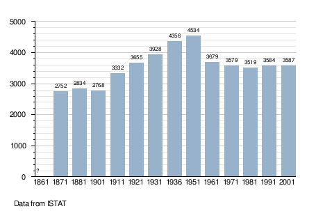
Demographic evolution
References
This article is issued from Wikipedia - version of the 1/31/2015. The text is available under the Creative Commons Attribution/Share Alike but additional terms may apply for the media files.