Lutovynivka
| Lutovynivka Лутовинівка | ||
|---|---|---|
|
Railway station in Lutovynivka (Hannivka) | ||
| ||
 Lutovynivka Location of Lutovynivka | ||
| Coordinates: 49°14′N 33°54′E / 49.233°N 33.900°ECoordinates: 49°14′N 33°54′E / 49.233°N 33.900°E | ||
| Country Oblast Raion |
Ukraine Poltava Oblast Kozelshchynskyi Raion | |
| Founded | 1923 | |
| Area | ||
| • Total | 1 km2 (0.4 sq mi) | |
| Elevation | 158 m (518 ft) | |
| Population | ||
| • Total | 2,000 | |
| • Density | 2,000/km2 (5,000/sq mi) | |
| Time zone | EET (UTC+2) | |
| • Summer (DST) | EET (UTC+3) | |
| Postal code | 39100 | |
| Area code(s) | +380 5342 | |
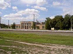
Lutovynivka (Ukrainian: Лутовинівка, Russian: Лутовиновка) is a small village, close to Kozelshchyna, in the Kozelshchynskyi Raion (district), Poltava Oblast (province) of central Ukraine, located 75 km from Poltava. The current estimated population is around 500 (as of 2012). Lutovynivka is also a railway station, and located close to the highway M22-E584.
References
- The information in this article is based on that in its Russian equivalent.
| Raions | |||||||
|---|---|---|---|---|---|---|---|
| Cities |
| ||||||
| |||||||
This article is issued from Wikipedia - version of the 5/20/2013. The text is available under the Creative Commons Attribution/Share Alike but additional terms may apply for the media files.