Madagascar subhumid forests
| Madagascar subhumid forests | |
|---|---|
|
| |
 | |
| Ecology | |
| Realm | Afrotropic |
| Biome | Tropical moist broadleaf forest |
| Borders | Madagascar ericoid thickets, Madagascar lowland forests, Madagascar spiny forests, Madagascar succulent woodlands, Madagascar dry deciduous forests |
| Animals | Lac Alaotra bamboo lemur, chameleons |
| Geography | |
| Area | 199,600 km2 (77,100 sq mi) |
| Country | Madagascar |
| Elevation | 600–1,800 metres (2,000–5,900 ft) |
| Coordinates | 18°56′S 47°31′E / 18.933°S 47.517°ECoordinates: 18°56′S 47°31′E / 18.933°S 47.517°E |
| Climate type | Tropical monsoon climate (Am), tropical savanna climate (Aw), humid subtropical climate (Cwa) |
| Conservation | |
| Conservation status | Critical/endangered |
| Global 200 | included |
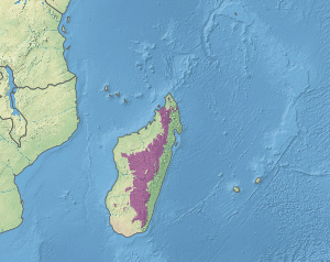
The Madagascar subhumid forests are a tropical moist broadleaf forest ecoregion that covers most of the Central Highlands of the island of Madagascar. They are included in the WWF's Global 200 list of outstanding ecoregions. Most of the original habitats have been lost due to human pressure.
Geography
The Madagascar subhumid forests ecoregion extends over most of the Central Highlands, above approximately 800 metres (2,600 ft) elevation on the east and above 600 metres (2,000 ft) meters elevation on the west. Most of that area is now covered by secondary grasslands and agriculture, with forest reduced to fragmented patches. The ecoregion has an area of approximately 199,600 square kilometers (77,100 sq mi). The highlands catch the wet northeast trade winds, while the areas to the south, west, and north lie in the drier rain shadow of the highlands.[1]
The subhumid forests are bounded by the humid Madagascar lowland forests along the coastal strip to the east, by the Madagascar dry deciduous forests to the north, northwest and west, and by the sub-arid Madagascar succulent forests and Madagascar spiny thickets to the southwest and south. In four areas above 1,800–2,000 metres (5,900–6,600 ft) elevation, the subhumid forests yield to the montane Madagascar ericoid thickets.[1]
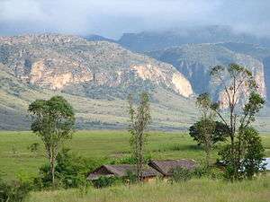
Montagne d'Ambre near the northern tip of the island, contains a significant pocket of subhumid forest, surrounded at lower elevations by dry deciduous forest, as do Ankaratra, upland near Tsaratanana, Andringitra Massif, Ambohitantely Reserve, and the Ambohijanahary area. The subhumid forests ecoregion also includes the disjunct Analavelona and Isalo massifs to the southwest, surrounded by succulent forests at lower elevations, and wetlands such as Lake Alaotra. The Sambirano region in the northwest is a particular centre of endemism.[1]
Flora
The original flora of ecoregion has been much altered by human use; extensive areas have been cleared for agriculture, grazing, and rice cultivation, and some exotic species such as Acacia and Eucalyptus have been introduced. Pockets of closed-canopy evergreen forest still exist, as do open-canopy woodlands, such as a type of hard-leaved forest dominated by tapia (Uapaca bojeri). Endemic species also included succulents in the genera Aloe and Kalanchoe. Large areas are now covered by grassland, but the extent to which the grasslands are the result of human intervention is still subject to debate.[1]
Fauna
Endemic species include a number of birds, reptiles and mammals including the Alaotra gentle lemur (Hapalemur alaotrensis) and a number of shrews, tenrecs, and rodents. The subhumid forests were formerly home to the island's distinct megafauna, including giant lemurs, some of them larger than modern gorillas, the elephant birds (Aepyornithidae), and giant tortoises.[1]
Threats and conservation
Madagascar's high plateau forests have been altered by humans in most places. There has been extensive slash-and-burn activity by native peoples in the central highlands, eliminating most forest. Other impacts include land clearing for agricultura, overexploitation, and pollution.[1]
Protected areas include Marojejy National Park, Isalo National Park, and the upper slopes of Ranomafana National Park. There are some smaller forest reserves, including Ambohijanahary and Ambohitantely.
See also
References
- 1 2 3 4 5 6 Crowley, H. (2004). "30 – Madagascar Subhumid Forests". In Burgess, N.; D'Amico Hales, J.; Underwood, E.; et al. Terrestrial Ecoregions of Africa and Madagascar: A Conservation Assessment. World Wildlife Fund Ecoregion Assessments (2nd ed.). Washington D.C.: Island Press. pp. 271–273. ISBN 978-1559633642. Archived from the original (PDF) on 2016-11-01.
External links
- "Madagascar subhumid forests". Terrestrial Ecoregions. World Wildlife Fund.