Maffra
| Maffra Victoria | |||||||
|---|---|---|---|---|---|---|---|
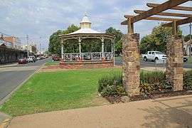 Maffra streetscape, 2013 | |||||||
 Maffra | |||||||
| Coordinates | 37°57′S 146°59′E / 37.950°S 146.983°ECoordinates: 37°57′S 146°59′E / 37.950°S 146.983°E | ||||||
| Population | 5,112 (2011 census)[1] | ||||||
| Postcode(s) | 3860 | ||||||
| Elevation | 27 m (89 ft) | ||||||
| Location |
| ||||||
| LGA(s) | Shire of Wellington | ||||||
| State electorate(s) | Gippsland East | ||||||
| Federal Division(s) | Gippsland | ||||||
| |||||||
Maffra is a town in Victoria, Australia, 220 kilometres (140 mi) east of Melbourne. It is in the Shire of Wellington local government area. It relies mainly on dairy farming and other agriculture,[2] and is the site of one of Murray-Goulburn Cooperative's eight processing plants in Victoria. Maffra is a detour off the Princes Highway and is near Sale, Stratford, Newry, Tinamba, Heyfield and Rosedale.[2] At the 2011 census, Maffra had a population of 5,112.[1]
History
The town began as an outstation of the region's first cattle run, Boisdale, named by pioneer grazier Lachlan Macalister after a village on the island of South Uist in the Outer Hebrides, Scotland. The town appears to have taken its name from a group of squatters from Maffra, a village in the Monaro region of NSW, with its location between current Maffra and Newry being written on an early map. The squatters moved on, but the name remained. The Monaro Maffra was probably connected to Mafra, a town in Portugal.
The township was settled in the 1860s, the Post Office opening on 20 July 1864.[3]
It was long the beef cattle capital of West Gippsland and, for many years, the only beet sugar processing centre in the country. The Beet Museum, set in the Port of Maffra Park, has relics from the defunct sugar beet industry. The building is a relocated historic weighbridge building, and is lined with pine boards from the home of Charles and Grace Quirk, one of Maffra's first cottages.[2]
Today
Maffra hosts a Mardi Gras every March, the Maffra and District Agricultural, Pastoral and Horticultural Show in October and a tennis tournament at Easter.
Maffra is considered to have one of the prettiest main streets (Johnson St) in Victoria. The Wellington Shire Council removed the 100+ year old trees that line it because of disease, but has since replaced them with young oaks.
Maffra has two primary schools, the Maffra Primary School and St Mary's Primary School (Catholic). Maffra also has a public secondary school, Maffra Secondary College, which has a student enrolment of around 700. Maffra Secondary has a strong academic program and is involved in a number of community service programs.
The Gippsland Vehicle Collection Motor Museum[4] is for lovers of old cars. It is housed in a huge old sugar beet building which the Car Club has cleaned and given new life.
In recent years Maffra has become a hub for backpackers seeking to complete Regional work requirements to achieve a second year visa. With growing salad and vegetable farming industries in the surrounding area it is considered a great town for working travelers. Maffra Lodge provides accommodation all year round to cater for backpackers.
A local group is working at Bellbird Corner, restoring the area to the popular picnic area it was in the 1900s.[2]
Sport
The town has an Australian Rules football team competing in the Gippsland Football League.[5]
Maffra is also home to a field hockey club, fielding junior, women's and men's teams in the East Gippsland Hockey Association playing at Cameron Sports Complex, Morison Street.
Golfers play at the course of the Maffra Golf Club on Fulton Road.[6]
Notable people
- Bill Bennett, AFL Player, member of Carlton's 1968 premiership side with 16 premierships
- John Hipwell, Australian architect
- John Butcher, AFL Player with Port Adelaide Football Club
- Shane Watts former world champion off-road motorcycle racer
- Dale Jennings (OAM) Service through a range of charitable, social welfare and business organisations. [7]
- Allan McLean, Australian Politician
References
- 1 2 http://www.abs.gov.au/websitedbs/censushome.nsf/home/map. Missing or empty
|title=(help) - 1 2 3 4 "Maffra, Victoria - Towns in Australia". Retrieved 2009-01-24.
- ↑ Premier Postal History, Post Office List, retrieved 2008-04-11
- ↑ Gippsland Vehicle Collection Motor Museum
- ↑ Full Points Footy, West Gippsland Latrobe Football League, archived from the original on 16 March 2009, retrieved 2009-04-15
- ↑ Golf Select, Maffra, retrieved 2009-05-11
- ↑ https://www.gg.gov.au/sites/default/files/files/honours/ad/ad2009/Media%20notes%20OAM%20(F-L)%20(final).pdf
External links
![]() Media related to Maffra, Victoria at Wikimedia Commons
Media related to Maffra, Victoria at Wikimedia Commons