Manendragarh
| Manendragarh मनेन्द्रगढ़ | |
|---|---|
| Municipal Town | |
 Manendragarh  Manendragarh Location in Chhattisgarh, India | |
| Coordinates: 23°11′32″N 82°12′01″E / 23.1922°N 82.2003°ECoordinates: 23°11′32″N 82°12′01″E / 23.1922°N 82.2003°E | |
| Country |
|
| State | Chhattisgarh |
| District | Koriya |
| Government | |
| • MP | Dr. Banshi Lal Mehto (Bharatiya Janata Party) |
| • MLA | Mr. Shyam Bihari Jaiswal (Bharatiya Janata Party) |
| • Municipal Chairman | Rajkumar Kesharwani(CONGRESS) |
| Area | |
| • Total | 10 km2 (4 sq mi) |
| Population (2011) | |
| • Total | 33,071 |
| • Density | 3,300/km2 (8,600/sq mi) |
| Languages | |
| • Official | Hindi, Chhattisgarhi |
| Time zone | IST (UTC+5:30) |
| PIN | 497442 |
| Telephone code | +91 7771 |
| Vehicle registration | CG-16 |
Manendragarh is a municipal city of the Koriya district that is a part of the state of Chhattisgarh. The city housing the taluk headquarters along with few important district head offices is sited near the Chhattishgarh -Madhya Pradesh state border.
The nearest airport is at Raipur in Chhattisgarh. Manendragarh Railway Station is on the Anuppur-Chirmiri rail route. There are many coal mines around here. Manendragarh was originated by some tribals around 100 years ago; later developed by British Raj for coal excavation. Road and Railway Lines are developed by the British.
National Highway 47 has its route through Manendragarh. Amrit Dhara Waterfall is a nearby attraction. "Sidh-Baba" mount is famous for the Lord Shiva temple..
Demographics
As of the 2011 India census,[1] Manendragarh had a population of 30,748. Males constitute 53% of the population and females 47%. Manendragarh has an average literacy rate of 72%, higher than the national average of 59.5%: male literacy is 79%, and female literacy is 64%. In Manendragarh, 13% of the population is under 6 years of age. Manendragarh is the hub of rural items.
Minerals
Region of Manendragarh has vast reserves of high-grade coal. The main coal belts are in the Hasdo basin. There are small deposits of limestone, fire clay and red oxide in Manendragarh.
Drainage
A part of Manendragarh region lies in the Ganges basin and the remaining portion is in the Mahanadi basin. Gopad is the major tribute of Son and originates about 10 miles North of Mendra village. It drains the Northern portion of the District. Hasdeo a major tributary of Mahanadi has its origin in Mendra village.
Forest
Manendragarh has vast range of forests. Up to the last decade of the 19th century, Korea
Botany
Most common trees of Korea District are Sal, Mahua, Tendu, Palas, Char, Bija, Harra, Bahera, Sisam, Kusum, Salya, Khair, Arun, Gamhar etc. Bamboos are mostly available in the forests.
Rivers
The Hasdeo river is the largest river flowing towards the South. It rises from 23°30´ North by 82°30´ East on the Sonhat Plateau and drains the South-Western part of the District. In this District, the river course resembles an upturned 'S' and flows for about 95 km. After a course of about 72 km, it enters Bilaspur District at 23° North. It receives the waters of the Gej and the Chornai on the left bank and the Tan and the Ahiran on the right before it meets the Mahanadi. The total length of the river is 245 km. The valley is narrow. Important settlements along the river are Sonhat, Ghugra, Manendragarh, Kosgain, Korba and Champa.
Place to visit near Manendragarh
1. Hotel Hasdeo Inn,Manendragarh: One of the biggest hotels in this area. With facility of AC room, multicusine restaurant, Bar and Lawn Banquet. 2. Hotel Vinay is situated In heart of city Hotel is well maintained 2. Amrit Dhara Waterfall Amrit Dhara Waterfall the natural beauty of Koriya is known all over India. The place is full of dense forests, mountains, rivers and waterfalls. Amrit Dhara Waterfall in Koriya is among the most famous waterfalls . The area around is also a famous picnic spot. People go for picnic and family get together to this place. The Amrit Dhara waterfall is easily accessible from Koriya and other parts of Chhattisgarh. There is a Shiva Temple here too. In 1936, Ramanuj Pratap Singh Judeo, the King of Koriya State, started a mela (fair) here on Mahashivratri, and the practice is followed till today.
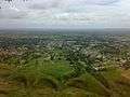 Mountain View
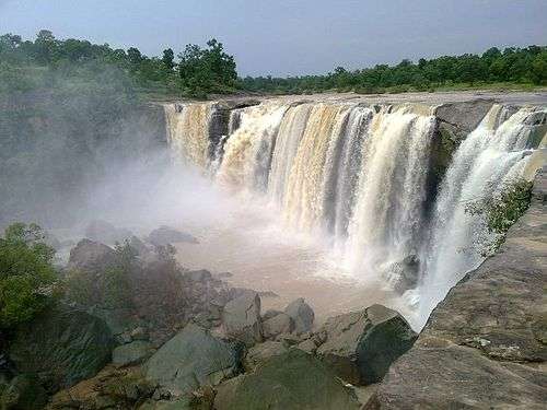 amrit dhara
3. Siddh Baba Temple : Siddh Baba Temple is situated on one of the hills of the town
4. Hasdeo River : Hasdeo River is a preferred Picnic spot for people of Manendragarh, Nagar Pakila has developed this place as key point to visit, there are group of temples on the bank of river
.jpg) Hasdeo River
Hasdeo River.jpg) Hasdeo River
Hasdeo River.jpg) Hasdeo River
Hasdeo River.jpg) Hasdeo River
Hasdeo River.jpg) Hasdeo River
Hasdeo River.jpg) Hasdeo River
Hasdeo River
5. Karam Ghonga: Kaaram Ghonga is the neared water fall and nice to spend a day excursion.
.jpg) Karam Ghonga Water fall
Karam Ghonga Water fall.jpg) Karam Ghonga Water fall
Karam Ghonga Water fall.jpg) Karam Ghonga Water fall
Karam Ghonga Water fall.jpg) Karam Ghonga Water fall
Karam Ghonga Water fall
- Karam Ghonga Water fall
- Karam Ghonga Water fall
- Karam Ghonga Water fall
- Karam Ghonga Water fall
beside these places there are several other places which is popular because of its attractiveness like Surabhi park Biharpur is also a very good picnic spot for the people of manendragarh located 35 km away from MDGR (Manendragarh) 11. Seroulli :- The place situated near udalkachar halt station. There is ancient hanuman temple there. Every year mela was held on occasion of hanuman jayanti.
Education
College/School
- Govt. Vivekanand college
- Alaska Computer College
- Rajiv Gandhi Computer College
- Kendriya Vidyalaya Railway, Manendragarh
- Kendriya Vidyalaya SECL, North Jhagrakhand
- Sarsawati Shishu Mandir, Manendragarh
- Sarsawati Shishu Mandir, Jhagrakhand
- Sarswati Kanya Maha Vidyalaya
- Shardesh Higher Secondary School
- Saint Patrick Academy
- Saint Joseph's Mission School (Branch of Bijuri)
- Saint Joseph's Convent School (JKD)
- The Gurukul International School
- Gurukul Vidya Mandir (Mouharpara)
- Blossom's Academy
- Bachpan - A play school
universal public school Saraswati vikas vidyalaya
Transport
By road
- National High way 43 connects Manendragarh with other part of state, Buses services are operate between different city of Madhya Pradesh, Chhatisgrah, Uttar Pradesh, Jharkhand and Bihar
By air
- Nearest airport is Raipur
- Another nearby airport is Jabalpur
By Train
Bilapur=Chirimiri Train is available to reach there
- Manendragarh Railway station has direct connectivity with many cities of Madhya Pradesh and Chhattishgarh.
Manendragarh station is situated on Anuppur - Chirmiri railine
References
- ↑ "Census of India 2001: Data from the 2001 Census, including cities, villages and towns (Provisional)". Census Commission of India. Archived from the original on 2004-06-16. Retrieved 2008-11-01.