Manitowoc River


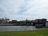

The Manitowoc River is a 35.8-mile-long (57.6 km)[1] river in eastern Wisconsin in the United States. It flows into Lake Michigan at the city of Manitowoc.
Course
The Manitowoc River is formed in eastern Calumet County by its north and south branches:
- The South Branch Manitowoc River, the longer of the two at 36.6 miles (58.9 km),[1] rises in northeastern Fond du Lac County and flows generally northeastwardly into Calumet County, passing the city of Chilton and collecting the Killsnake River.
- The North Branch Manitowoc River rises in northern Calumet County and flows 22.2 miles (35.7 km) generally southeastwardly.[1]
From the confluence of its forks, the Manitowoc flows generally eastwardly through central Manitowoc County to its mouth at Lake Michigan in the city of Manitowoc. Its largest tributary is the Branch River.
Little Manitowoc River
The Little Manitowoc River is a 10.6-mile-long (17.1 km)[1] stream that flows into Lake Michigan about 1 mi (2 km) north of the mouth of the Manitowoc River.
See also
References
- 1 2 3 4 U.S. Geological Survey. National Hydrography Dataset high-resolution flowline data. The National Map, accessed December 19, 2011
Sources
- Columbia Gazetteer of North America entry
- DeLorme (1992). Wisconsin Atlas & Gazetteer. Freeport, Maine: DeLorme. ISBN 0-89933-247-1.
- U.S. Geological Survey Geographic Names Information System: Manitowoc River
- U.S. Geological Survey Geographic Names Information System: Little Manitowoc River
Coordinates: 44°05′31″N 87°39′05″W / 44.0919°N 87.6514°W
This article is issued from Wikipedia - version of the 9/11/2016. The text is available under the Creative Commons Attribution/Share Alike but additional terms may apply for the media files.