Mapulaca
| Mapulaca | |
|---|---|
| Municipality | |
|
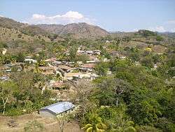
Panoramic View of Mapulaca | |
 Mapulaca Location in Honduras | |
| Coordinates: 14°02′N 88°37′W / 14.033°N 88.617°W | |
| Country | Honduras |
| Department | Lempira |
| Area | |
| • Total | 32 km2 (12 sq mi) |
| Population (2015) | |
| • Total | 4,314 |
| • Density | 130/km2 (350/sq mi) |
Mapulaca is a municipality in the Honduran department of Lempira.
It is one of the smallest municipalities in the south of Lempira department. It is hard to get there and the traveller can take any road, however, the suggested option is via Santa Rosa de Copán-San Marcos de Ocotepeque-Cololaca-Valladolid-La Virtud-Mapulaca. On the other hand, if the traveller is coming from La Esperanza, Intibuca obviously the road to take is via Santa Cruz-San Andrés-Candelaria-Either way it takes about 5 or 6 hours to get there. There is a well known point on the border, "El Puente Colgante" (The Hanging Bridge), which leads to Sonsonate municipality in El Salvador. Also there is a new bridge called "Puente La Intregracion."
History
Founded on 30 October 1692. In the census of 1791, it was part of "Curato de Cerquin". It has real state titles granted by the "Convent" of Gracias on 10 March 1817. Subscribed by his majesty King Felipe IV. In 1889 it was a municipality of Candelaria district.
Geography
It is located approximately at 300 mts above sea level, and after coming down "Congolón" mountain. It is surrounded by some high hills and by dry sub tropical forests, and it applies for the rest of the municipality. It also has some flat lands for sowing and more recently for people settlement.

Boundaries
Its boundaries are:
- North : Gualcince municipality.
- South : El Salvador.
- East : Candelaria and Virginia municipalities.
- West : La Virtud municipality.
- Surface Extents: 32 km²
Resources
The main economical activity is commerce, and especially since the border is only 3 km away from the departmental capital. The next activity is corn and beans crops and in a smaller scale is cattle and milk products, these last are mostly for local consumption. It has had electricity for 4 years now and also mobile communication services. The water is obtained from wells, but it is not enough for the local demand. It has 2 hardware stores and several groceries stores. In some houses, people sell gasoline or diesel fuels.
Population
The cross-breed of Spanish and Indians is the majority, but the traits of Indians are more common to see.
- Population:The population in 2001 was 3,866, and according to estimates by the INE Honduras, 4,314 is expected for 2015.
- Villages: 5
- Settlements: 35
Tourism
Due to its geography and location, Mapulaca is only a place to pass by. The "Puente Colgante" is the place of the border to go to El Salvador. It is necessary to cross the hanging bridge to make it to Chalatenango municupality in El Salvador. This bridge is an adventure itself, it was built by a Swiss man also known as "Toni El Suizo", who built more hanging bridges after hurricane Mitch back in 1998. The "Lempa" river is a good place for swimming, but its currents are very strong and dangerous, so extreme care is advised. There are several tributary rivers to Lempa river, which are also nice places to cool off. There is only one hostel in Mapulaca with the only one "restaurant", which is quite small.
- Local Holidays: "San Juan de Dios' day, on 8 March.
Gallery
 Central Park in Mapulaca
 The Small Church in Mapulaca
 A Street in Mapulaca
 Lempa River on the border, near Mapulaca
 The Hanging bridge to El Salvador
 In Honor to the Bridge Maker
 Welcome to El Salvador
Capital: Gracias | ||
| Municipalities |  | |
Coordinates: 14°02′N 88°37′W / 14.033°N 88.617°W