San Andrés, Lempira
| San Andrés | |
|---|---|
| Municipality | |
|
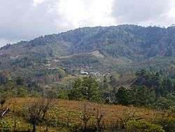
Panoramic View of San Andrés town | |
 San Andrés Location in Honduras | |
| Coordinates: 14°11′6″N 88°30′0″W / 14.18500°N 88.50000°W | |
| Country | Honduras |
| Department | Lempira |
| Area | |
| • Total | 243 km2 (94 sq mi) |
| Population (2015) | |
| • Total | 13,585 |
| • Density | 56/km2 (140/sq mi) |
San Andrés is a municipality in the Honduran department of Lempira.
It is notable as the principal site in Honduras for the mining of andesite opals from Las Colinas deposit near Sosoal, which is in the municipality. This mining is largely performed by artisanal miners, rather than on an industrial scale.[1]
It is approximately 120 km from Gracias city. It is about 1 hour away from Erandique city.
History
In the census of 1801 it was known as "Guaxinlaca" village, under the delegation of "Gracias a Dios". In the national division of 1889, it appeared as a municipality of Erandique district.
Geography
Since it is located on the mountains, the main forests are Pines and Oaks. Its elevation above sea level is the proper one for coffee plantations. Its mountains and hills are very high and steep. It has several water spring running down the steep hills. One curiosity is a huge rock monolith on the way to the departmental capital, which proves the volcanic origins of the rocks in this municipality and the rest of the department.

Boundaries
Its boundaries are:
- North : La Campa, San Sebastián and Santa Cruz municipalities.
- South : Gualcince municipality.
- East : Erandique municipality.
- West : Valladolid, Tambla and Tomalá municipalities.
- Surface Extents: 243 km²
Resources
The main product of this municipality is coffee, taking advantage of its elevation from sea level and soil conditions. Vegetables, Corn and Beans are second in importance, and then follows cattle raising and milk products. These last items are mostly for local consumption. The exploitation of the forest is rational yet. There is electricity, but they sometimes have problems with it, and the absence can last up to 3 days. There is also coverage of mobiles services. And in some houses, people sell gasoline and diesel fuel.
Population
In the particular case of this municipality, the descendants of Indians take the highest percent, mostly in the surrounding villages. The cross-breed of Spanish and Indians takes the rest.
- Population:The figure in 2001 was 10,472, and according to estimates by the INE Honduras, 13,585 is expected for 2015.
- Villages: 8
- Settlements: 144
Tourism
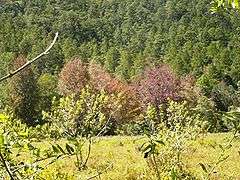
The deviation to San Andrés is better known as "El Guayabo"; from there, is 15 minutes left to the main town. In some sections the road narrows down to 1 lane and others it turns very slippery, so caution is advised. The best attraction it has are the forests, especially "Liquidambar" forest, because when they change their leaves depending on the season, the landscapes are just gorgeous. The coffee "Fincas" also provide amazing views. There are no hostels, or any places to stay, but since it close to Erandique, that can be solved. It doesn't have a formal place to eat either, but there's an old lady, about half a block away from the Mayor's office, who cooks delicious typical meals. On the holidays, many people attend and some bring their products.
- Local Holidays: "San Andrés" day on 30 November.
References
External links
| Wikimedia Commons has media related to San Andrés. |
Capital: Gracias | ||
| Municipalities |  | |