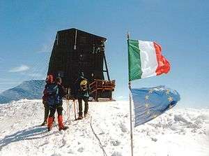
Margherita Hut

The Margherita Hut (Italian: Capanna Regina Margherita) is a mountain hut belonging to the Italian Alpine Club, located on the Signalkuppe of Monte Rosa in the Alps.
Location
At 4,554 metres (14,941 ft) above sea level, it is the highest building in Europe. It is also among the largest huts of the massif, together with the Monte Rosa Hut. The Margherita Hut is located in Italian territory , near the international border between Italy and Switzerland, in the Italian region of Piedmont. The nearest settlements are Macugnaga and Alagna Valsesia, both in Piedmont.
History
The construction of the hut was directed by the Italian Alpine Club in 1889. The hut was pre-built in the valley, then brought to its final destination by mule and then by men, and assembled on site. It was opened on August 18, 1893, in the presence of Margherita of Savoy, Queen of Italy, to whom the hut is dedicated.
The hut soon became an important research center for high-elevation medicine, under the direction of Angelo Mosso. As the hut was quite small, in 1907 a newer, lower research center ("Istituto Mosso") was built near the Salati Pass, at an elevation of about 2,900 metres (9,500 ft).
In 1899 a meteorological station was added.
A complete restoration started in 1977. The original hut was dismantled, and was replaced by the current hut, which opened in 1980.
Features
The hut is owned by the central committee of the Italian Alpine Club (CAI), but it is managed by the local CAI section of Varallo Sesia.
The hut is open and managed in the summer, from early June to early September, the exact dates varying from year to year. It provides recuperation and accommodation, having 70 beds. In winter, there is an unmanaged winter facility with 12 beds.
Access
The hut can only be accessed on foot. The walk to the hut usually takes two days; climbers spend a night at the Gnifetti Hut, the Monte Rosa Hut or the Resegotti Hut, from where they set off for the Margherita Hut on the following morning. The walk requires physical fitness and a good knowledge of alpine techniques.
References
- Swisstopo topographic and cadastral maps
External links
![]() Media related to Capanna Regina Margherita at Wikimedia Commons
Media related to Capanna Regina Margherita at Wikimedia Commons
Coordinates: 45°55′38″N 7°52′37″E / 45.92722°N 7.87694°E