Signalkuppe
| Signalkuppe | |
|---|---|
| Punta Gnifetti | |
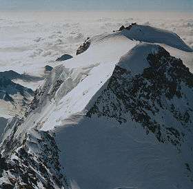 The Signalkuppe lying behind the Zumsteinspitze. The Margherita hut is just visible on the summit. | |
| Highest point | |
| Elevation | 4,554 m (14,941 ft) |
| Prominence | 102 m ↓ Colle Gnifetti |
| Isolation | 0.7 km → Zumsteinspitze |
| Parent peak | Dufourspitze of Monte Rosa |
| Coordinates | 45°55′38″N 7°52′37″E / 45.92722°N 7.87694°ECoordinates: 45°55′38″N 7°52′37″E / 45.92722°N 7.87694°E |
| Geography | |
 Signalkuppe Alps | |
| Location |
Piedmont, Italy / Valais, Switzerland |
| Parent range | Pennine Alps |
| Climbing | |
| First ascent | 9 August 1842 by Giovanni Gnifetti and party |
| Easiest route | Glacier tour via west flank, south-west ridge (F) |
The Signalkuppe (in German, pronounced seen-yall-koo-pay) also known as Punta Gnifetti (in Italian) (4,554 m) is a peak in the Pennine Alps on the border between Italy and Switzerland. It is a subpeak of Monte Rosa. The mountain is named after 'the Signal', a prominent gendarme atop the east ridge, named Cresta Signal.
The first ascent was made by Giovanni Gnifetti, a parish priest from Alagna Valsesia, together with J. Farinetti, C. Ferraris, C. Grober, J. and G. Giordiano and their porters on 9 August 1842.
The highest hut in Europe, the Margherita Hut (named after Italy's Queen consort Margherita of Savoy) lies on the summit of the mountain. Work started in 1890, supported by the Italian crown, and Queen Margherita opened it in 1893. The new hut, a high-altitude Faraday Cage, is clad in sheet copper to shield against unwanted electrical fields.
See also
References
- Dumler, Helmut and Willi P. Burkhardt, The High Mountains of the Alps, London: Diadem, 1994
- Collomb, Robin G., (ed.), Pennine Alps Central, London: Alpine Club, 1975
External links
- The Signalkuppe on SummitPost
- Photographic account of an ascent of the Signal ridge (in Italian)
- Margherita hut page (Capanna Margherita, in Italian)
- Margherita hut official page from Rifugimonterosa.it (in english)
- Other photos of Margherita hut ascent from Alagna (in Italian)
| Wikimedia Commons has media related to Signalkuppe. |