Maryland Route 983
| ||||
|---|---|---|---|---|
 | ||||
| Route information | ||||
| Maintained by MDSHA | ||||
| Existed: | 1963 – present | |||
| MD 983 | ||||
| Length: | 1.02 mi[1] (1.64 km) | |||
| South end: | Dead end in North Laurel | |||
| North end: | Old Scaggsville Road in North Laurel | |||
| MD 983A | ||||
| Length: | 0.71 mi[1] (1.14 km) | |||
| South end: | Dead end in Scaggsville | |||
| North end: | Leishear Road / Old Scaggsville Road in Scaggsville | |||
| Location | ||||
| Counties: | Howard | |||
| Highway system | ||||
| ||||

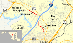
Maryland Route 983 (MD 983) is the unsigned designation for a pair of state highways in the U.S. state of Maryland. The highways form parts of the old alignment of MD 216 on either side of Interstate 95 (I-95) in North Laurel in southeastern Howard County, Maryland. MD 983 has a length of 1.02 miles (1.64 km) and runs on the east side of I-95. MD 983A spans 0.71 miles (1.14 km) on the west side of I-95. MD 216 through North Laurel was built in the early 1920s. The segments of MD 983 were designated when MD 216 was relocated east of I-95 in the early 1960s and west of I-95 in the early 1970s.
Route description
MD 983 begins at a dead end at the Patuxent River in North Laurel; the dead end is on the opposite side of the river from the northern end of Ninth Street in the city of Laurel. The highway heads northwest as two-lane Old Scaggsville Road, which has intersections with Pilgrim Avenue and All Saints Road, which provide access to MD 216. MD 983 veers north ahead of its intersection with Stansfield Road, which passes under I-95 and indirectly connects with MD 983A. The state highway ends at the state–county maintenance boundary southeast of and adjacent to the MD 216–I-95 cloverleaf interchange. Old Scaggsville Road continues as a county street that curves east before ending in a residential community.[1][2] MD 983A begins at a cul-de-sac on the west side of the MD 216–I-95 interchange. The highway heads west as two-lane Scaggsville Road. MD 983A reaches its western terminus at Leishear Road; the road continues west as Old Scaggsville Road, which is designated MD 216E.[1][3]
History
The two segments of MD 983 are part of the old alignment of MD 216, which crossed the Patuxent River on a bridge at Ninth Street in Laurel.[4] The highway was constructed as a gravel road from Laurel to Scaggsville in 1923; that road was paved in 1956.[5][6] MD 216's present bridge across the river at Seventh Street was built in 1960.[7] The highway was relocated to its present alignment from Main Street in Laurel to the site of the I-95 interchange in 1963, leaving behind much of what is now MD 983.[8] The interchange was built in 1970 and 1971.[9][10] MD 216 was moved to its present alignment from the interchange west to Leishear Road between then and 1978, leaving behind MD 983A.[11] The Patuxent River crossing at Ninth Street was removed, resulting in MD 983's present dead end at the river, in 1985.[12] MD 983A connected directly with MD 216 at the Leishear Road intersection until MD 216 was relocated to its present course between Leishear Road and U.S. Route 29 in 2005.[13]
Junction list
The entire route is in Howard County.
| Location | mi[1] | km | Destinations | Notes | |||
|---|---|---|---|---|---|---|---|
| North Laurel | 0.00 | 0.00 | Dead end at Patuxent River | Southern terminus of MD 983 | |||
| 1.02 | 1.64 | Old Scaggsville Road north | Northern terminus of MD 983; end of state maintenance | ||||
| Gap between routes at I-95 | |||||||
| Scaggsville | 0.00 | 0.00 | Cul-de-sac | Southern terminus of MD 983A | |||
| 0.71 | 1.14 | Leishear Road north / Old Scaggsville Road west | Northern terminus of MD 983A; Old Scaggsville Road is MD 216E | ||||
| 1.000 mi = 1.609 km; 1.000 km = 0.621 mi | |||||||
See also
 Maryland Roads portal
References
- 1 2 3 4 5 Highway Information Services Division (December 31, 2013). Highway Location Reference. Maryland State Highway Administration. Retrieved 2013-09-11.
- Howard County (PDF)
- ↑ Google (2012-01-30). "Maryland Route 983" (Map). Google Maps. Google. Retrieved 2012-01-30.
- ↑ Google (2012-01-30). "Maryland Route 983A" (Map). Google Maps. Google. Retrieved 2012-01-30.
- ↑ Laurel, MD quadrangle (Map) (1942 ed.). 1:62,500. 15 Minute Series (Topographic). United States Geological Survey.
- ↑ Maryland Geological Survey (1923). Map of Maryland: Showing State Road System and State Aid Roads (Map). Baltimore: Maryland Geological Survey.
- ↑ Maryland State Roads Commission (1956). Maryland: Official Highway Map (Map). Baltimore: Maryland State Roads Commission.
- ↑ Federal Highway Administration (2012). "NBI Structure Number: 100000130044010". National Bridge Inventory. Federal Highway Administration.
- ↑ Maryland State Roads Commission (1963). Maryland: Official Highway Map (Map). Baltimore: Maryland State Roads Commission.
- ↑ Federal Highway Administration (2012). "NBI Structure Number: 100000130076013". National Bridge Inventory. Federal Highway Administration.
- ↑ Maryland State Roads Commission (1971). Maryland: Official Highway Map (Map). Baltimore: Maryland State Roads Commission.
- ↑ Maryland State Highway Administration (1978). Maryland: Official Highway Map (Map). Baltimore: Maryland State Highway Administration.
- ↑ Maryland State Highway Administration (1985). Maryland: Official Highway Map (Map) (1985–86 ed.). Baltimore: Maryland State Highway Administration.
- ↑ Highway Information Services Division (December 31, 2005). Highway Location Reference. Maryland State Highway Administration. Retrieved 2013-09-11.
- Howard County (PDF)