Massachusetts Route 116
| ||||
|---|---|---|---|---|
|
Map of western Massachusetts with Route 116 highlighted in red | ||||
| Route information | ||||
| Maintained by MassDOT | ||||
| Length: | 68.26 mi[1] (109.85 km) | |||
| Major junctions | ||||
| South end: |
| |||
| North end: |
| |||
| Location | ||||
| Counties: | Hampden, Hampshire, Franklin, Berkshire | |||
| Highway system | ||||
| ||||

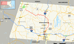
Route 116 is a south–north state highway in Massachusetts. The route runs from Springfield through mill towns, college towns and rural towns, crossing the Connecticut River three times before finally ending in Adams.
Route description
Route 116 begins at Route 20A in Springfield, just before that route ends at its parent route and I-91. The route junctions with the interstate officially at Exit 11, before entering the city of Chicopee. The route crosses I-91 without junction before meeting I-391 twice, on either side of the Chicopee River. It then crosses under the Massachusetts Turnpike (I-90) before curling through Chicomansett Village. In the northwest corner of Chicopee Route 141 becomes concurrent with the route, just east of I-391, which it crosses without junction. It then crosses the Willimansett Bridge into Holyoke, passing through the downtown area on two one-way streets, with Route 141 leaving the route during that time. It then becomes one route again, crossing a canal before crossing the Vietnam Memorial Bridge into South Hadley and Hampshire County.
In South Hadley, Route 116 meets U.S. Route 202 with a cloverleaf interchange. After meeting the northern end of Route 33 it continues northward, passing Mount Holyoke College, where Route 47 begins. It then turns northeastward, passing through the northwest corner of Granby before clipping South Hadley again on the way into Amherst. The route passes Hampshire College and Amherst College before meeting Route 9 at the center of town. Route 116 then becomes concurrent with Route 9, heading westward before entering Hadley and turning northward again, passing the western edge of UMass Amherst, passing behind Warren McGuirk Alumni Stadium. The route meets the southern end of Route 63 before meeting Sunderland Road before passing into Franklin County and the town of Sunderland.
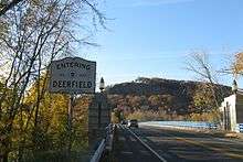

In Sunderland, Route 116 passes west of the Great Swamp and Bull Hill before crossing Route 47 again in the town center before crossing the Connecticut River a third time, over the Sunderland Bridge into Deerfield. The route then meets U.S. Route 5 and Route 10 just over the Whately town line, and just north of I-91 Exit 24. It then follows Routes 5 & 10 for about a mile before leaving the route, heading westward and crossing I-91 at Exit 25. The route heads northwestward, passing through the Mill River area of town and passing into Conway.
Once the route enters Conway, it becomes a winding route, passing through that town center before continuing into Ashfield. In Ashfield, the route becomes Main Street, before it has a wrong-way concurrency with Route 112 for nearly a mile and a half. the route then turns westward, passing Spruce Corner on its way back into Hampshire County and the town of Plainfield. The route acts as the main road through the town before meeting Route 8A near the Dubuque Memorial State Forest. The two routes head westward into Berkshire County and the town of Savoy. In Savoy, Route 8A heads south while Route 116 heads westward into the town of Cheshire. Route 116 passes through the northeast corner of town before entering Adams and finally terminating at Route 8 in the southern end of downtown Adams.
History
Prior to 1955, Route 116 did not have a concurrency with Route 9 or enter Hadley. Rather, it continued along Pleasant Street and North Pleasant Street, passing along the eastern side of UMass before meeting Sunderland Road, where it rejoins the current route. This was done to lessen traffic along the edge of the campus. When the route was moved, Route 63's southern terminus was also moved along Meadow Street to connect it back to Route 116.
In 2012, part of the road near Atkins Farm in Amherst was relocated to the east to remove a sharp curve in the road.
Major intersections
| County | Location | mi | km | Destinations | Notes |
|---|---|---|---|---|---|
| Hampden | Springfield | 0.00 | 0.00 | Southern terminus | |
| 0.9 | 1.4 | Exit 11 on I-91 | |||
| Chicopee | 2.2 | 3.5 | Exit 2 on I-391 | ||
| 3.3 | 5.3 | Exit 3 on I-391 | |||
| 5.8 | 9.3 | Southern end of Route 141 concurrency | |||
| Holyoke | 7.6 | 12.2 | Northern end of Route 141 concurrency | ||
| Hampshire | South Hadley | 9.4 | 15.1 | Cloverleaf intersection | |
| 10.4 | 16.7 | Northern terminus of Route 33 | |||
| 12.2 | 19.6 | Southern terminus of Route 47 | |||
| Amherst | 21.5 | 34.6 | Southern end of Route 9 concurrency | ||
| Hadley | 22.8 | 36.7 | Northern end of Route 9 concurrency | ||
| Amherst | 26.1 | 42.0 | Southern terminus of Route 63 | ||
| Franklin | Sunderland | 30.9 | 49.7 | ||
| Whately | 32.7 | 52.6 | Southern end of US 5/Route 10 concurrency | ||
| Deerfield | 33.6 | 54.1 | Northern end of US 5/Route 10 concurrency | ||
| 33.8 | 54.4 | Southbound exit and northbound entrance only; exit 25 on I-91 | |||
| Ashfield | 47.2 | 76.0 | Southern end of Route 112 wrong-way concurrency | ||
| 48.6 | 78.2 | Northern end of Route 112 wrong-way concurrency | |||
| Hampshire | Plainfield | 57.8 | 93.0 | Southern end of Route 8A wrong-way concurrency | |
| Berkshire | Savoy | 63.5 | 102.2 | Northern end of Route 8A wrong-way concurrency | |
| Adams | 68.26 | 109.85 | Northern terminus | ||
1.000 mi = 1.609 km; 1.000 km = 0.621 mi
| |||||
References
External links
| Wikimedia Commons has media related to Massachusetts Route 116. |