Massachusetts State Highway System
|
Standard highway shields | |
| System information | |
|---|---|
| Notes: | Routes are not always state-maintained, and not all state highways are Routes. |
| Highway names | |
| Interstates: | Route I-X or Route X |
| US Highways: | Route US X or Route X |
| State: | Route X |
| System links | |


In the U.S. state of Massachusetts, the highway division of the Massachusetts Department of Transportation (MassDOT) assigns and marks a system of state-numbered routes. U.S. Highways and Interstate Highways are included in the system; the only overlaps are with the end-to-end U.S. Route 3 and Route 3 and the far-apart Interstate 295, shared with Rhode Island, and Route 295, shared with New York State. A state highway in Massachusetts is a road maintained by the state, which may or may not have a number. Not all numbered routes are maintained or owned by the state.
History
The Massachusetts Highway Commission (MHC) was the first highway commission in the U.S., formed in 1893 in response to a commission of inquiry finding that over 90% of the public roads in the state were in poor condition.[1][2] The first state highway in Massachusetts was a 5305.17-foot (1617.02 m) section of Fitchburg Road (now Main Street, part of Route 119) in Ashby. The MHC laid it out as a state highway on August 15, 1894 from a point west of South Road to a point west of Route 31. The road was paved with 15–20 foot (4.5–6 m) macadam, with work beginning August 21, 1894 and ending July 15, 1895. The 50–66 foot (15–20 m) right-of-way is still owned by MassDOT under the original layout.[3][4]
Massachusetts first gained numbered routes in 1922, with the formation of the New England Interstate Highways. Three-digit numbers were reserved for shorter routes. Route 138 and Route 140 were designated by 1925, and by 1926 the numbers from Route 101 to Route 142 (except Route 136) had been assigned.
The establishment of the U.S. Highway System in 1926 resulted in several of the New England Interstate routes having to be renumbered. The New England Interstate routes that conflicted with new U.S. Highway numbers were assigned newly freed single-digit numbers. Beginning in 1929, local routes were assigned new two-digit numbers. With the exception of Route 143, which was renumbered from Route 109A ca. 1933, new routes were given two-digit numbers for a while. Larger three-digit numbers were eventually assigned.
Over the years, most of the state's highways have been maintained by a varied list of agencies, including the Massachusetts Highway Department, Massachusetts Turnpike Authority, and the Massachusetts Port Authority, but are now maintained by the consolidated MassDOT. The Massachusetts Department of Conservation and Recreation's Bureau of Engineering still manages and/or operates a number of parkways across the Commonwealth.
All routes that end at a state border and continue as a numbered route on the other side have been renumbered on one side of the border to match. Except for Route 295, far from Interstate 295, numbers that were duplicated with Interstate Highways were renumbered, mostly in 1959 when the Interstate numbers were assigned.
- The longest numbered highway in the state is U.S. Route 20, which runs for 153 miles (246 km).
- The longest state highway is Route 28, which runs for 151.92 miles (244.49 km).
- The longest Interstate highway in Massachusetts is Interstate 90 (the Mass Pike), which runs 138.1 miles (222.3 km).
- The shortest route in Massachusetts is Route 15, which runs for only 0.23 miles (0.37 km). The shortest signed highway is Route 108, which runs for 0.92-mile (1.48 km). Both are short extensions of state highways in neighboring states. The shortest route completely within state borders is Route 240, which runs for 1-mile (1.6 km).
- The shortest Interstate in Massachusetts is Interstate 295, which runs as a 4-mile (6.4 km) extension of I-295 in Rhode Island.
Signage practices
State routes
Massachusetts uses a simple design for its state route shields. Black numerals are displayed on a plain white shield, usually with a black border near the edge of the sign, although this differs from sign to sign, especially on highway overheads. Single- and double-digit state highway numbers are posted on standard square sign panels, while three-digit (and three- and four-character alternate such as 28A) numbers are displayed on elongated panels. State route shields on freeways, such as Route 24 and Route 128 have the same design, but are usually much larger in size for easier viewing at highway speeds.
Some older, erroneous signs have the sign in a white circle, and black on the outside, although occurrences of this are rare.
U.S. Routes
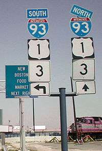
Massachusetts uses the standard white-shield on black background design for its U.S. Routes, used in all states except for California. Signs for U.S. Routes on green highway signs generally omit the black background, but some older signs still have them. A number of signs installed on the U.S. Route 3 expressway are of a cut-out design, without the black background. U.S. Routes on freeways usually have extra-large sign panels posted.
NOTE: Alternates of U.S. routes in Massachusetts are signed as state highways (Routes 1A, 3A (northern), 6A, 7A, and 20A).
Interstate Highways
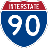
Massachusetts uses standard Interstate highway shields without the state name on the shield, although a small number of very old signs do exist with the state name. Interstate shields are usually of the extra-large variety, with the exception of the Massachusetts Turnpike (Interstate 90), which uses standard shields.
Auxiliary routes

Massachusetts does not use auxiliary tabs for route signage, and as such contains no bypass or business routes. Massachusetts formerly had "city routes", which were signed C1, C9, C28, and C37, as city alignments of the respective state routes. All of these designations were decommissioned in the early 1970s. Since then, no route in Massachusetts has ever had more than one alternate, save for multiple sections of a single numbered route such as 1A, 2A or 3A. (a Route 3B existed in the 1920s but was renumbered to Route 38).
The Lowell Connector was technically the only "auxiliary" route in the state, having been formerly signed as Interstate 495 Business Spur in the 1960s.
Exit numbering
Massachusetts is one of the few U.S. states that still uses sequential exit numbering on its freeways. The state amendments to the 2009 national MUTCD, published in January 2012, stated that Massachusetts would be changing all exit numbers to the mileage-based system "within the next five to ten years".[5] This change will be made in 2016 when a project to renumber all currently numbered exits to those based on highway mileposts is started.[6] Exit numbers are posted on all of its Interstate Highways, as well as other major freeways in the state, including the freeway portions of Route 2, the Pilgrims Highway (part of Route 3), the Northwest Expressway (part of US 3), Route 24, Route 25, Route 128, the southern portion of Route 140, Route 213, and most recently, Route 146.
Five freeways in Massachusetts contain irregular exit numbering patterns:
- On Route 2, exit numbers start at 14 and increase to 43, with a gap in the freeway between Acton and Lexington. Exit numbering resumes at 52 and ends at 60.
- The Northwest Expressway (US 3) is the one freeway in Massachusetts that still uses the "25 is 128" system. As such, its exit numbering scheme starts at 25 (at Route 128/I-95) and goes up to 36.
- Route 128 has reversed exit numbering; that is, exit numbers increase going north-to-south. Exit numbers start at 29 and end at 10. There are no exits 1-9, there is no exit 11, and exit 27 was removed. Route 128 has always had this system; however most of its exit numbering was replaced by the standard south-to-north of I-93 and I-95 south of Peabody.
- I-93 in Boston has gone under many exit numbering changes since the Big Dig project was completed, and many old interchanges were closed or reconfigured. Numbering on the Interstate goes from 1 to 48, but the following exit numbers no longer exist: 17, 19, 21, 22, and 25.
- Numbering on the Massachusetts Turnpike (I-90) increases from 1 to 26; however, exits 14 and 15 are the same exit, exits 18 and 20 are the same exit, exit 19 is a mainline toll plaza, and exits 21 and 23 are on-ramps only.
Signage errors
Massachusetts is rather notorious for the placement of incorrect signage along its numbered highways. Some of these errors are due to outdated signage which have not been replaced since a realignment or truncation of a route, which can lead to confusion as to where a particular route goes. Lack of route signage in urban areas is a common problem.
One very common signage error, which occurs in many states, is the mis-signage of a U.S. highway as a state route (mostly on guide signs). This occurs in many places along U.S. Route 202, as well as on sections of U.S. Route 20 and in a few spots along U.S. Route 1, U.S. Route 6 and U.S. Route 44. These are less confusing sign errors, as U.S. routes are part of the Massachusetts state highway system, and thus do not share numbers with other state routes (the one exception being U.S./MA Route 3, which connect end-to-end and are treated as the same route by the state).
A more unusual signage error occurred at the intersection of Route 10 and Route 141 in Easthampton in July 2005, in which Alabama state route markers were installed for the two routes. This error came from a contractor who mistakenly signed the route based on the design in the federal manual that showed an Alabama route marker.[7][8]
See also
References
- ↑ Massachusetts Registry of Motor Vehicles, History of the Massachusetts License Plate
- ↑ "Journey by Land: Automobiles & Highways". Pilgrim Hall Museum. May 18, 2005. Archived from the original on February 4, 2012. line feed character in
|title=at position 17 (help) - ↑ MassDOT state highway layout plan 1 (August 15, 1894)
- ↑ MassDOT state highway layout plans: About page
- ↑ Highway Division (2012). "Section 2E.31: Interchange Exit Numbering". The Massachusetts Amendments to the 2009 Manual on Uniform Traffic Control Devices and the Standard Municipal Traffic Code (PDF). Massachusetts Department of Transportation. p. 62. Retrieved August 7, 2013.
- ↑ "Exit Signage Conversion to Milepost-Based Numbering System along Various Interstates, Routes and the Lowell Connector". Massachusetts Department of Transportation. September 12, 2015. Retrieved September 14, 2015.
- ↑ Daniel, Mac (July 26, 2005). "Word to road crews: Tuscaloosa is over 1,000 miles thataway". The Boston Globe. Retrieved December 31, 2009.
- ↑ "Alabama road signs in Massachusetts?". WSFA-TV. Retrieved December 31, 2009.
External links
- Highway Division of the Massachusetts Department of Transportation
- Massachusetts Department of Transportation, Office of Transportation Planning - Data Resources Section (includes a road inventory and maps)
- Neilbert.com Massachusetts Route Log
- The Roads of Massachusetts
- Road Signs of Massachusetts
- Massachusetts Roadtrips
- Speculative Massachusetts Future Exit Number Lists
Road jurisdiction maps:
- Interactive road jurisdiction map
- District 1 Road Jurisdiction PDF map (Berkshires and western Pioneer Valley)
- District 2 Road Jurisdiction PDF map (west-central)
- District 3 Road Jurisdiction PDF map (east-central)
- District 4 Road Jurisdiction PDF map (Boston metro and northeastern )
- District 5 Road Jurisdiction PDF map (Cape Cod and southeastern)