Massachusetts Route 14
| ||||
|---|---|---|---|---|
 | ||||
| Route information | ||||
| Maintained by MassDOT | ||||
| Length: | 18.46 mi[1] (29.71 km) | |||
| Existed: | 1933, 1936 (current alignment) – present | |||
| Major junctions | ||||
| West end: |
| |||
|
| ||||
| East end: |
| |||
| Location | ||||
| Counties: | Plymouth | |||
| Highway system | ||||
| ||||

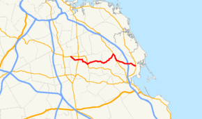
Route 14 is an 18.5-mile highway in southeastern Massachusetts. It runs from Route 27 in Brockton east to Route 3A in Duxbury, near the coastline.
Massachusetts Route 3 (Pilgrims Highway) has an interchange with Route 14, at Exit 11 in Duxbury.
Route description
From its western terminus at Route 27 in Brockton, Route 14 goes through Whitman south of the center of the town before going the northeastern corner of East Bridgewater, crossing Route 27 once more. In Hanson, the road is concurrent with Route 58 through the center of town, past Wampatuck Pond. It passes into Pembroke between Oldham Pond and Furnace Pond before passing through the center of town. After another concurrency with Route 53, the road passes into Duxbury, crossing Route 3 before ending at Route 3A west of Duxbury Village.
History
In 1933, Route 14 was extremely short, with its western terminus at Route 3 (current Route 53). By 1936 it had been extended out to its current routing in Brockton.
Major intersections
The entire route is in Plymouth County.
| Location | mi | km | Destinations | Notes | |
|---|---|---|---|---|---|
| Brockton | 0.00 | 0.00 | Western terminus | ||
| Whitman | 2.00 | 3.22 | |||
| East Bridgewater | 4.70 | 7.56 | |||
| Hanson | 6.90 | 11.10 | Western terminus of concurrency with Route 58 | ||
| 7.30 | 11.75 | Eastern terminus of concurrency with Route 58 | |||
| Pembroke | 10.30 | 16.58 | Northern terminus of Route 36 | ||
| 12.10 | 19.47 | Western terminus of concurrency with Route 53 | |||
| 13.80 | 22.21 | Eastern terminus of concurrency with Route 53 | |||
| Duxbury | 16.40 | 26.39 | Exit 11 on Route 3 | ||
| 17.30 | 27.84 | Eastern terminus of Route 139 | |||
| 18.46 | 29.71 | Eastern terminus | |||
1.000 mi = 1.609 km; 1.000 km = 0.621 mi
| |||||
References
| Wikimedia Commons has media related to Massachusetts Route 14. |