Mataquescuintla
| Mataquescuintla | |
|---|---|
| Municipality | |
| Mataquescuintla | |
|
Captain General Rafael Carrera, president for life of Guatemala (1840-1865). Used Mataquescuintla as his military headquarters for several years. [1][2][3] | |
 Mataquescuintla Location within Guatemala | |
| Coordinates: 14°32′1″N 90°11′2″W / 14.53361°N 90.18389°WCoordinates: 14°32′1″N 90°11′2″W / 14.53361°N 90.18389°W | |
| Country |
|
| Department |
|
| Villa | 1848 |
| Incorporated | 1848 |
| Government | |
| • Type | Mayor–Council |
| • Body | Mataquescuintla municipal council |
| • Mayor of Mataquescuintla | Hugo Manfredo Loy |
| Area | |
| • Total | 237 km2 (92 sq mi) |
| Elevation | 1,727 m (5,000 ft) |
| Population (2012)Censo de Guatemala, 2012 | |
| • Total | 32,860 |
| Demonym(s) |
|
| Time zone | Central America (UTC-6) |
| Climate | Cwb |
| Website | Mataquescuintla municipality |

Mataquescuintla is a municipality in the Jalapa department of Guatemala. During the 19th century, it served as the headquarters for the peasant militia of general Rafael Carrera.[1]
References
Bibliography
- Woodward, Ralph Lee (1993). Rafael Carrera and the Emergence of the Republic of Guatemala, 1821-1871. Athens, GA: University of Georgia Press.
Capital: Jalapa | ||
| Municipalities | 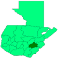 | |
This article is issued from Wikipedia - version of the 9/1/2016. The text is available under the Creative Commons Attribution/Share Alike but additional terms may apply for the media files.