Mathur Aqueduct
| Mathoor Hanging Trough | |
| Length of flume | 1240 ft (378 m) |
| Width | 7.5 ft (2.3 m) |
| Height of trough | 7 ft (2.1 m) |
| Velocity | 5.1 ft/s (1.55 m/s) |
| Discharge | 204 ft³/s (5.8 m³/s) |
| No. of span pillars | 28 |
| Length of span | 40 ft (12.2 m) |
| Bed level, trough at start | 91 in (2.31 m) |
| Bed level, trough at end | 90 in (2.29 m) |
| Maximum height above ground level | 115 ft (35 m) |
| Construction cost | Rs. 12.90 lakhs – in 1966 |
| Coordinates | 8°20′10″N 77°17′40″E / 8.3361111°N 77.2945667°ECoordinates: 8°20′10″N 77°17′40″E / 8.3361111°N 77.2945667°E |
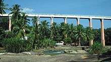
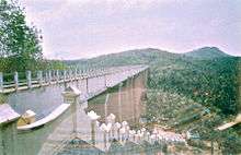
Mathur Aqueduct or Mathur Hanging Trough, is an aqueduct in southern India, in Kanyakumari District of Tamil Nadu state. Built over the Pahrali River (also called Parazhiyar), it takes its name from Mathur, a hamlet near the aqueduct, which is about 3 kilometres from Thiruvattar town and about 60 km from Kanyakumari, the southernmost town of India. It is one of the longest and highest aqueducts in South Asia and is a popular tourist spot in Kanyakumari District. The nearest railway station is Kullithurai Railway Station which is about 15 kilometres away and the nearest airport is the Trivandrum International Airport which is about 70 kilometres awaay.
Purpose
Mathur Aqueduct was constructed in 1966 by the then Chief Minister of Tamil Nadu, K. Kamaraj, as a drought relief measure across the river Pahrali. Its purpose is to carry water for irrigation from an elevated level of one hill to another. The irrigation water feeds the taluks of Vilavancode and Kalkulam.
Construction

The aqueduct is built across the Pahrali river, a small river that originates in the Mahendragiri Hills of the Western Ghats. Mathur Aqueduct itself carries water of the Pattanamkal canal for irrigation over the Pahrali, from one hill to another, for a distance of close to one kilometer. This aqueduct is needed because of the undulating land terrain of the area, which is also adjacent to the hills of the Western Ghats.
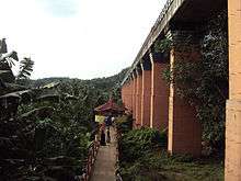
Mathur Aqueduct is a concrete structure supported by 28 huge pillars, the maximum height of the pillars reaching 115 ft. The trough structure is 7 ft in height, with a width of 7.5 ft. The trough is partly covered with concrete slabs, allowing people to walk on the bridge and to see the water going through the trough. Some of the pillars are set in rocks of the Pahrali river, though some of the pillars are set in hills on either side.
There is road access to one end of the aqueduct and to the foot of the aqueduct (the level where the Pahrali flows) on the opposite side. There is a huge flight of stairs, made more recently, that allows one to climb from the level of the Pahrali river to the trough.
Irrigation water flows through the trough for a large part of the year, except in the summer (from February to May).
Tourist attraction

In recent times, Mathur Aqueduct has become a popular tourist attraction in Kanyakumari District. The tourism department and the local Panchyat office have improved facilities for visiting tourists.
From the centre of the aqueduct, one can see a vast expanse of greenery, with rolling hills of the Western Ghats in the background, and the meandering Pahrali river flowing below.
Mathur Aqueduct is about 60 km from the popular tourist town of Kanyakumari and about 60 km from the city of Trivandrum, the capital of Kerala state. [1]
Notes
- ↑ "Mathur Hanging Bridge". Retrieved 28 October 2006.
External links
| Wikimedia Commons has media related to Mathur Aqueduct. |