Matoaca, Virginia
| Matoaca, Virginia | |
|---|---|
| CDP | |
|
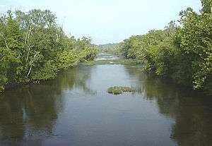
The Appomattox River at Matoaca | |
 Location of Matoaca, Virginia | |
| Coordinates: 37°13′41″N 77°28′14″W / 37.22806°N 77.47056°WCoordinates: 37°13′41″N 77°28′14″W / 37.22806°N 77.47056°W | |
| Country | United States |
| State | Virginia |
| County | Chesterfield |
| Area | |
| • Total | 2.7 sq mi (6.9 km2) |
| • Land | 2.5 sq mi (6.6 km2) |
| • Water | 0.1 sq mi (0.3 km2) |
| Elevation | 141 ft (43 m) |
| Population (2010) | |
| • Total | 2,403 |
| • Density | 890/sq mi (350/km2) |
| Time zone | Eastern (EST) (UTC-5) |
| • Summer (DST) | EDT (UTC-4) |
| FIPS code | 51-50136[1] |
| GNIS feature ID | 1497010[2] |
Matoaca is a census-designated place (CDP) in Chesterfield County, Virginia, United States. The population was 2,403 at the 2010 census.[3] It is named after the Pamunkey princess Matoaka who was better known by her nickname "Pocahontas".[4] It was near the site of an Appomattoc village Matoka or Matoks, which was reputedly her girlhood home, and the palace town of the weroansqua Oppussoquionuske.[5]
In 2016 it was listed as No. 42 in CNN Money's Top 50 Places to Live in the United States.[6]
History
Olive Hill was listed on the National Register of Historic Places in 1975.[7]
Geography
Matoaca is located at 37°13′41″N 77°28′14″W / 37.22806°N 77.47056°W (37.228138, -77.470437).[8]
According to the United States Census Bureau, the CDP has a total area of 2.7 square miles (7.0 km2), of which 2.5 square miles (6.5 km2) is land and 0.1 square miles (0.26 km2), or 4.49%, is water.
Demographics
As of the census[1] of 2000, there were 2,273 people, 866 households, and 651 families residing in the CDP. The population density was 892.0 people per square mile (344.2/km²). There were 911 housing units at an average density of 357.5/sq mi (137.9/km²). The racial makeup of the CDP was 65.55% White, 32.12% African American, 0.22% Native American, 0.31% Asian, 0.04% Pacific Islander, 0.26% from other races, and 1.50% from two or more races. Hispanic or Latino of any race were 0.75% of the population.
There were 866 households out of which 34.2% had children under the age of 18 living with them, 53.8% were married couples living together, 16.2% had a female householder with no husband present, and 24.8% were non-families. 20.8% of all households were made up of individuals and 9.6% had someone living alone who was 65 years of age or older. The average household size was 2.62 and the average family size was 3.03.
In the CDP the population was spread out with 27.2% under the age of 18, 6.2% from 18 to 24, 29.7% from 25 to 44, 22.9% from 45 to 64, and 14.0% who were 65 years of age or older. The median age was 38 years. For every 100 females there were 90.1 males. For every 100 females age 18 and over, there were 86.6 males.
The median income for a household in the CDP was $50,000, and the median income for a family was $56,163. Males had a median income of $33,722 versus $26,071 for females. The per capita income for the CDP was $19,810. About 5.8% of families and 6.2% of the population were below the poverty line, including 2.9% of those under age 18 and 10.6% of those age 65 or over.
Education
See Chesterfield County Public Schools
The local schools are Matoaca Elementary School Matoaca Middle School and Matoaca High School.
References
- 1 2 "American FactFinder". United States Census Bureau. Retrieved 2008-01-31.
- ↑ "US Board on Geographic Names". United States Geological Survey. 2007-10-25. Retrieved 2008-01-31.
- ↑ "Profile of General Population and Housing Characteristics: 2010 Demographic Profile Data (DP-1): Matoaca CDP, Virginia". U.S. Census Bureau, American Factfinder. Retrieved November 29, 2011.
- ↑ Gannett, Henry (1905). The Origin of Certain Place Names in the United States. U.S. Government Printing Office. p. 203.
- ↑ Francis E. Lutz, 1954, Chesterfield - An Old Virginia County, p. 10, 15.
- ↑ Time, Sept. 19, 2016
- ↑ National Park Service (2010-07-09). "National Register Information System". National Register of Historic Places. National Park Service.
- ↑ "US Gazetteer files: 2010, 2000, and 1990". United States Census Bureau. 2011-02-12. Retrieved 2011-04-23.
Municipalities and communities of Chesterfield County, Virginia, United States | ||
|---|---|---|
| CDPs |  | |
| Unincorporated communities | ||