May 1995 Louisiana flood
The May 1995 Louisiana flood, also known as the May 8–10, 1995, New Orleans area flood event, struck the New Orleans metropolitan area, shutting down the city for two days.
The entire 40-hour event from the evening of Monday, May 8, through the morning of Wednesday, May 10, consisted of two distinct heavy rainfalls. By Wednesday morning, storm total rainfall amounts of 10 to 20 inches (25 to 51 cm) were common across portions of southeast Louisiana and south Mississippi. Six persons were killed. The event was later estimated to have caused more than $3.1 billion in damage.[1]
Meteorological synopsis
A cold front approached the region from the west, preceded by a squall line. The airmass that entered western Louisiana on May 8 exhibited considerably lower dewpoints than the tropical airmass across east Louisiana and southeast Mississippi. The mid-level short wave which accompanied the cold front quickly exited to the northeast, causing the front to weaken and slow. By the evening of May 9, the cold front dissipated in the vicinity of Baton Rouge. The remnant frontal trough served as a focusing axis for heavy precipitation that continued into the late morning hours of May 10. An upper-level trough became negatively tilted to the west of the area, providing ample upper-level divergence as well as mid-level and upper-level cold and dry air advection. At the surface, warm and moist air moved in from the Gulf of Mexico continually during the event. The swath of highest rainfall totals was closely tied to a theta-e ridge at the 850mb pressure surface, which stretched from the central Gulf of Mexico into the Mississippi River Delta area.
The massive rainfall totals were generally caused by the stalled out frontal system. Heavy, "training" thunderstorms continued to form over the same areas for several hours. Pumping stations were overwhelmed and could not pump out the water into Lake Pontchartrain. At the time, pumping stations were only rated to pump 1 inch (2.5 cm) per hour maximum.
Timeline

- Approximately 5:30 p.m. on May 7th... heavy rainfall begins across areas south of Lake Pontchartrain, continuing into the early morning hours of May 8th.
- Early morning hours on May 8th... Flooding began in Jefferson Parish and Orleans Parish, including the cities of New Orleans, Metairie, Kenner, River Ridge, and Harahan
- Evening hours on May 9th... Heavy rainfall occurs across areas north of Lake Pontchartrain in Saint Tammany Parish, Louisiana, including Slidell, Covington, Mandeville, and Abita Springs. Heavy rainfall also occurs across south Mississippi, especially portions of Pearl River County, Hancock County, and Harrison County, including Bay St. Louis and Gulfport.
- Late evening May 9th... flooding begins extends into the Northshore areas of Louisiana and also coastal Mississippi.
- May 10th... severe river flooding impacts areas along the Wolf River, Tchoutacabouffa River, and Jourdan River in Mississippi, each of which set new record stages (Wolf River flooding from Hurricane Isaac in 2012 subsequently broke the record).
Rainfall
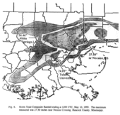
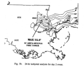
The heaviest rainfall from the first wave of rainfall occurred on the southshore of Lake Pontchartrain in the New Orleans metropolitan area, with a secondary maxima on the northshore. Heaviest rainfall from the second wave occurred across the northshore of Lake Pontchartrain and coastal Mississippi. By May 10th, rainfall totals of 10-20 inches were common. Some notable two-day totals from the National Weather Service archives and post-event surveys:
Official
- Abita Springs, LA: 24.46"
- Necaise, MS: 27.50"
- New Orleans (Tulane University), LA: 24.05"
- New Orleans (International Airport), LA: 9.67"
- New Orleans (Lakefront Airport), LA: 15.44"
- Slidell, LA: 19.09"
Unofficial/unknown source
- Harahan, LA: 14.88"
- Kenner, LA: 17.11"
- Metairie, LA: 19.39"
- New Orleans East, LA: 20.20"
- Mandeville, LA: 23.66"
- Madisonville, LA: 22.86"
- Covington, LA: 21.00"
- Lacombe, LA: 34.76"
- Hammond 8.54"
For both waves of rainfall, several locations neared or exceeded 24‑hour rainfall amounts estimated as having a 1% chance of being exceeded in a given year, (100 year average recurrence interval) as determined by both the National Weather Service Technical Paper 40 and reports by the Southern Regional Climate Center.
Impact
Some have compared this to the great November 1979 Louisiana flood, or the more recent November 7–8, 1989 Louisiana flood, though the May 8th flood was more extensive and costlier than both combined. It was the worst flooding the city had experienced between hurricanes Betsy in 1965 and Katrina in 2005. There has been no comparable recorded flood in New Orleans caused by rain alone, although rain also caused significant street flooding in New Orleans on Good Friday of 1927 and May 3, 1978.
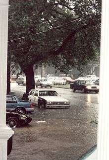
Six people died as a result of the flooding. The city of New Orleans suffered $360 million in damages, and the damage of the surrounding areas put that total above $3 billion.[1] Some 56,000 homes were damaged in 12 Parishes. Thousands of cars were flooded. 14,600 homes and apartments were flooded in Jefferson Parish alone.
Aftermath
New pumping stations were built and canals were expanded to prevent further catastrophic rainfall floods. Some politicians began to push for pumping rain waters directly into the Mississippi River, but environmental groups argued against this plan. The idea has since been raised in brainstorming for ideas in how to prevent flooding in New Orleans after Hurricane Katrina.
The flood prompted expansions and improvements of the city's drainage and pumping system, especially in the worst hit portions of the city, including improvements to the underground canals under Napoleon and Claiborne Avenues in Broadmoor and other SELA projects to improve drainage in Hollygrove connected to the 17th St. Canal.
See also
References
- 1 2 THE HISTORIC SOUTHEAST LOUISIANA AND SOUTHERN MISSISSIPPI FLOOD OF MAY 8-10, 1995 "NOAA Technical Memorandum NWS SR-183", Retrieved on 2012-12-06.
External links
-

Wikimedia Commons has media related to May_8th_1995_Louisiana_Flood. - Rainfall Frequency/Magnitude Atlas for the South-Central United States, by Faiers, G.E., B.D. Keim, and R.A. Muller. 1997, Geoscience Publications: Baton Rouge, Louisiana, 40 pp. , in PDF form
- Technical Paper 40: RAINFALL FREQUENCY ATLAS OF THE UNITED STATES, by Hershfield, David M. May 1961, Cooperative Studies Section, Hydrologic Services Division.
- Flood Danger Rises North of New Orleans, Marcus, Frances Frank. May 11, 1995.
- Television clips from WVUE-tv & WDSU-tv covering the May 1995 flooding. on YouTube
- Television clips from WWL-tv covering the May 1995 flooding.