Mayerling
Mayerling is a small village (pop: 200) in Lower Austria belonging to the municipality of Alland in the district of Baden. It is situated on the Schwechat River, in the Wienerwald (Vienna woods), 15 miles (24 km) southwest of Vienna. From 1550, it was in the possession of the abbey of Heiligenkreuz.
The Mayerling Incident
In 1886 Crown Prince Rudolf of Austria, only son of Emperor Franz Joseph I of Austria and Empress Elisabeth of Bavaria and heir to the Austro-Hungarian crown, acquired the manor and transformed it into a hunting lodge. It was in this hunting lodge that, on January 30, 1889, he was found dead with his mistress Baroness Mary Vetsera, apparently as a result of suicide. Exactly what happened is unknown but on 31 July 2015 the Austrian National Library issued copies of Vetsera's letters of farewell to her mother and other family members. The letters - written in Mayerling shortly before the deaths - state clearly and unambiguously that Vetsera was preparing to commit suicide alongside Rudolf, out of "love".[1]
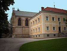
After the deaths of Prince Rudolf and Baroness Vetsera, the Emperor Franz Joseph, who wanted to found a new church, had the building turned into a convent which was settled by nuns of the Discalced Carmelite Order. Visitors may view the statue of the Madonna in the Lady Chapel of the church. It has the face of the Empress Elisabeth and has a dagger in the Immaculate Heart. The position of the main cross in the chapel is supposed to be where the bed of Rudolf and his lover Mary Vetsera was situated.
Today the lodge is a museum and tourist attraction in Austria. Prayers are still said daily by the nuns for the repose of the soul of Crown Prince Rudolf.
References
- ↑ Press release from the Austrian National Library, 31 July 2015 (German)
External links
| Wikimedia Commons has media related to Mayerling. |
Coordinates: 48°02′49″N 16°05′54″E / 48.04694°N 16.09833°E