McClugage Bridge
| McClugage Bridge | |
|---|---|
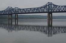 McClugage Bridge from the east side of the Illinois River. | |
| Coordinates | 40°43′12″N 89°32′45″W / 40.72000°N 89.54583°WCoordinates: 40°43′12″N 89°32′45″W / 40.72000°N 89.54583°W |
| Carries |
5 lanes (3 WB, 2 EB) of |
| Crosses | Illinois River |
| Locale | Peoria, Illinois |
| Official name | McClugage Bridge |
| Maintained by | Illinois Department of Transportation |
| ID number |
WB: 000090011505461 EB: 000090007019729[1] |
| Characteristics | |
| Design | Dual Cantilever bridges |
| Total length | 4,745.1 ft (1446.3 m)[1] |
| Width |
WB: 39.0 ft (11.9 m) EB: 28.9 ft (8.8 m)[1] |
| Longest span | 190 m |
| Load limit |
WB: 77.2 metric tons EB: 55.8 metric tons[1] |
| Clearance below | 14.9 m[1] |
| History | |
| Opened |
WB: 1982 EB: 1948, reconstructed 2000 |
| Statistics | |
| Daily traffic | 40,400 (combined)[2] |
The McClugage Bridge carries U.S. Route 150 over Upper Peoria Lake & Peoria Lake in the Illinois River in Illinois, United States. The bridge's official name honors David H. McClugage, mayor of Peoria from 1937 to 1941. The crossing is actually composed of two bridges, one carrying westbound traffic and one carrying eastbound traffic.
Southern span
The original span of the McClugage Bridge was designed as a steel cantilever bridge in 1939[3] to replace the Upper Free Bridge, an existing bridge across a narrow stretch of Upper Peoria Lake. Due to World War II, the bridge was not completed until 1948.[4] The southern span was rehabilitated in 2000. During rehabilitation, an accident in 2000 killed three iron workers when scaffolding on the bridge collapsed 62 feet (19 m) into the river. Due to this tragedy, there was an effort to change the name of the bridge to "Ironworkers Memorial Bridge". However, instead of the name change, the iron workers were memorialized by a monument near the bridge that was dedicated in April 2001.[5]
Northern span
An additional 3-lane span of similar style was constructed immediately north of the existing bridge in 1982.[3] Currently, the northern three-lane span carries westbound traffic and the original southern 2-lane span carries eastbound traffic.
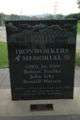 Ironworkers Memorial, located near Grand View Drive
References
- 1 2 3 4 5 "National Bridge Inventory Database Search - 2012". nationalbridges.com.
- ↑ Illinois Department of Transportation (2003). "Getting Around Illinois: Average Annual Daily Traffic". Retrieved 2007-03-30.
- 1 2 http://www.hanson-inc.com/bridges/bridges_mcclugage.htm
- ↑ "Bridgehunter.com - McClugage Bridge". bridgehunter.com.
- ↑ Peoria Journal Star, 4/19/2001
| Crossings of the Illinois River | ||||
|---|---|---|---|---|
| ||||