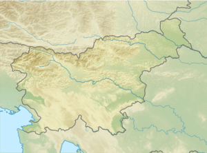
Mežakla
| Mežakla | |
|---|---|
 View of Mežakla from Jesenice | |
| Highest point | |
| Elevation | 1,348 m (4,423 ft) |
| Coordinates | 46°24′06″N 14°02′27″E / 46.40167°N 14.04083°ECoordinates: 46°24′06″N 14°02′27″E / 46.40167°N 14.04083°E |
| Geography | |
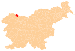
 Mežakla Location of Mežakla | |
| Location | Slovenia |
| Parent range | Julian Alps |
Mežakla (pronounced [mɛˈʒaːkla]) is a long undulating plateau about 15 km (9 mi) long in the foothills of the Julian Alps above the town of Jesenice in northwestern Slovenia. It ranges from approximately 1,200 m (3,900 ft) to 1,593 m (5,226 ft) high. It is mostly covered with spruce and beech trees. There are many pastures and clear streams on the plateau. Mežakla is part of Triglav National Park but tourism is underdeveloped.
Name
The name Mežakla was first attested in written sources as Moshägkhlä in 1579 (and as Musakhla in 1609 and Meſaqua in 1744). The name is derived from the dialect word mežek 'juvenile bear'.[1]
References
- ↑ Snoj, Marko. 2009. Etimološki slovar slovenskih zemljepisnih imen. Ljubljana: Modrijan and Založba ZRC, p. 261.
External links
- Mežakla on Geopedia
-
 Media related to Mežakla at Wikimedia Commons
| Municipalities | |||||||||||||||||||||||||||||||||||||||||||||||||||||||||||||||||||
|---|---|---|---|---|---|---|---|---|---|---|---|---|---|---|---|---|---|---|---|---|---|---|---|---|---|---|---|---|---|---|---|---|---|---|---|---|---|---|---|---|---|---|---|---|---|---|---|---|---|---|---|---|---|---|---|---|---|---|---|---|---|---|---|---|---|---|---|
| |||||||||||||||||||||||||||||||||||||||||||||||||||||||||||||||||||

This article is issued from Wikipedia - version of the 11/15/2015. The text is available under the Creative Commons Attribution/Share Alike but additional terms may apply for the media files.