Mickleham, Surrey
| Mickleham | |
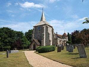 St. Michaels church |
|
 Mickleham |
|
| Area | 7.31 km2 (2.82 sq mi) |
|---|---|
| Population | 585 (Civil Parish 2011)[1] |
| – density | 80/km2 (210/sq mi) |
| OS grid reference | TQ171534 |
| Civil parish | Mickleham |
| District | Mole Valley |
| Shire county | Surrey |
| Region | South East |
| Country | England |
| Sovereign state | United Kingdom |
| Post town | Dorking |
| Postcode district | RH5 |
| Dialling code | 01372 or 01306 |
| Police | Surrey |
| Fire | Surrey |
| Ambulance | South East Coast |
| EU Parliament | South East England |
| UK Parliament | Mole Valley |
Coordinates: 51°16′05″N 0°19′16″W / 51.268°N 0.321°W
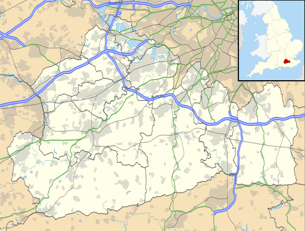
Mickleham is a village and civil parish[2] between the towns of Dorking and Leatherhead in Surrey, England covering 7.31 square kilometres (1,810 acres). The parish includes the hamlets of Fredley and Westhumble.
History
Mickleham lies near to the old Roman road known as Stane Street. Then, acquiring its Old English based name, the small settlement lay within the Copthorne hundred used for meetings of the wealthy and powerful for strategic purposes in Anglo-Saxon England.
Mickleham appears in Domesday Book of 1086 as Michelham and Micleham. It was partly held by Nigel from the Bishop of Bayeux and partly by Oswald from (under) Richard de Tonbridge. Its domesday assets were: 7 hides; 1 church, 7 ploughs, 3 acres (12,000 m2) of meadow, woodland worth 4 hogs. It rendered £10 per year to its overlords.[3]
Nearby Mickleham Down was the venue for a single wicket cricket match on Monday, 29 June 1730. The game was between two teams of three and played for a substantial stake of £50. The teams, Surrey and Sussex, were described in a contemporary newspaper report as "esteemed the best in the respective counties" but it does not name the players. The Sussex three won the match.[4] This is the first and only reference to Mickleham in association with cricket of a senior level.
Mickleham gets a mention in the 1815 novel, "Emma", by Jane Austen.
Ninety Victorian workmen, 'considered navvies' died in an accident when a tunnel they were working on collapsed, through Norbury Park, within the parish. The village has featured prominently in cycling, following the loops of Box Hill adopted by various versions of the London-Surrey Cycle Classic which has acquired a federation of European cycling points status as an annual event, since its use in the 2012 Summer Olympic Games.
Amenities
Places of worship
The main place of worship is St. Michael's Church, surrounded by St. Michael's Churchyard. The church (in full the "Parish Church of St. Michael and All Angels in Mickleham") has a Norman west tower and a Norman chancel arch, raised in the 1871 restoration by Ewan Christian, who added neo-Norman aisles and east end. The Norbury chapel on the north side is late Perpendicular, with chequerboard flint and clunch walling.[5]
Community facilities and commerce
The village has two pubs (The Running Horses and The King William IV), a village shop (Rose's Stores) and an Italian Restaurant (Frascati).
The Mickleham Village Hall is on Dell Close and is available for hire.
Schools
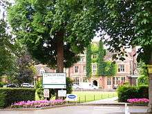
In the village are Box Hill School, an independent secondary school, located close to the village shop, St Michael's Infant C of E (Aided) School and St Michael's Community Nursery.
Transport
- Roads
The A24 bypasses Mickleham with a dual-carriageway bypass.
- Railway
Box Hill & Westhumble station, located across the A24, and towards Westhumble, provides a link to London and Horsham.
- Buses
The 465 bus route runs every hour or half-hour (except nights) between Kingston upon Thames and Dorking, via Mickleham village.
Localities
Fredley
Due south of the village 300m from its main cluster of buildings is the manor and hamlet of Fredley where is sited the Field Studies Council's Juniper Hall.
The Burford Bridge and the zig-zag road
Here is the hotel that was frequented by Lord Nelson, 150m north of which starts the Zig-Zag road, one of the two local roads for motor vehicles climbing Box Hill.
Norbury Park
Across the Mole and the A24 is Norbury Park. In this is the 'Druids Grove' which is an area of mature Yew trees.
Landmarks
The surrounding area contains many Sites of Special Scientific Interest (SSSI) including the Mickleham Downs and panoramic beauty spot of Box Hill.
The River Mole flows nearby. As its name suggests, the river in places goes underground due to the chalk bed being dissolved, forming swallow holes (sinkholes). Ian Middleton tells of his father, sometime in the 1950s, the village police officer P.C. Middleton, looking past his bathroom mirror one morning whilst shaving to see a mature oak tree disappear into the ground. It turned out that the river flowing underground had been gradually wearing away the supporting ground under the tree, forming a giant such hole which had collapsed. The subsequent pit was not filled in until about 1968 approx when it was still 30 ft deep and 30 ft across. P.C. Middleton also reportedly removed parts from an unexploded V2 rocket which fell in the village during World War II.
Famous inhabitants
- Richard Bedford Bennett, 1st Viscount Bennett, Prime Minister of Canada from 1930 to 1935, retired here after his life in politics. He is buried in St Michael's Churchyard, the only former Prime Minister of Canada not buried in that country.
- Sir John Norton-Griffiths, 1st Baronet, "Empire Jack", the driving force behind the Tunnelling companies of the Royal Engineers in WW I, was buried at Mickleham Church on 18 October 1930.
- Detective story writer Cyril Hare was born in Mickleham Hall in 1900 and died at Westhumble in the parish in 1958; he is buried in the churchyard. So is his wife's grandfather, Sir Trevor Lawrence, who had famous orchid houses at Burford Lodge in the parish.
- Mrs. Maria Drummond lived at Fredley and was buried here.
- Conversation Sharp, politician, had his country retreat at 'Fredley Farm' and entertained many leading figures of the day there. :[6]
- William Wingfield (MP), was born here.
- Calum MacPherson, actor and bon vivant lived here.
- Lettice Rowbotham, violinist from Mickleham, participated in the Britain's Got Talent 2014 Finals.
Demography and housing
| Output area | Detached | Semi-detached | Terraced | Flats and apartments | Caravans/temporary/mobile homes | shared between households[1] |
|---|---|---|---|---|---|---|
| (Civil Parish) | 74 | 51 | 15 | 35 | 0 | 0 |
The average level of accommodation in the region composed of detached houses was 28%, the average that was apartments was 22.6%.
| Output area | Population | Households | % Owned outright | % Owned with a loan | hectares[1] |
|---|---|---|---|---|---|
| (Civil Parish) | 585 | 175 | 27.4% | 24.6% | 731 |
The proportion of households in the civil parish who owned their home outright compares to the regional average of 35.1%. The proportion who owned their home with a loan compares to the regional average of 32.5%. The remaining % is made up of rented dwellings (plus a negligible % of households living rent-free).
See also
HMS Mickleham, a Ham class minesweeper; the village gave its name to this.
References
- 1 2 3 Key Statistics; Quick Statistics: Population Density United Kingdom Census 2011 Office for National Statistics Retrieved 21 November 2013
- ↑ Surrey Council census
- ↑ Surrey Domesday Book
- ↑ Buckley, p. 4.
- ↑ Ian Nairn and Nikolaus Pevsner, The Buildings of England - Surrey, 1962
- ↑ Knapman, D. - 'Conversation Sharp - The Biography of a London Gentleman, Richard Sharp (1759-1835), in Letters, Prose and Verse'. Chapter 9. . (Private Publication, 2004) British Library.
Bibliography
- Buckley, G. B. (1935). Fresh Light on 18th Century Cricket. Cotterell.
- Maun, Ian (2009). From Commons to Lord's, Volume One: 1700 to 1750. Roger Heavens. ISBN 978-1-900592-52-9.
External links
| Wikimedia Commons has media related to Mickleham, Surrey. |
- Parish of Mickleham
- Mickleham Choral Society
- Leach, John (2008). "Classification of cricket matches from 1697 to 1825". Stumpsite. Archived from the original on 29 June 2011.
- Leach, John (2007). "From Lads to Lord's – 1730". Stumpsite. Archived from the original on 29 June 2011.
|
|  | ||||||||||||||||||||||||||||||
|---|---|---|---|---|---|---|---|---|---|---|---|---|---|---|---|---|---|---|---|---|---|---|---|---|---|---|---|---|---|---|---|---|
| Parks | ||||||||||||||||||||||||||||||||
| Places of worship | ||||||||||||||||||||||||||||||||
| Education | ||||||||||||||||||||||||||||||||
| Transport |
| |||||||||||||||||||||||||||||||
Buildings and structures | ||||||||||||||||||||||||||||||||
| Sport |
| |||||||||||||||||||||||||||||||
Places listed are articles notable as settlements, arranged by post town The two principal towns are emboldened | ||||||||||||||||||||||||||||||||