Mikindani
- For the Mikindani in Mombasa, Kenya, see Mikindani, Kenya
Mikindani [translation: young palm trees], is a coastal African, Swahili town in south-eastern Tanzania.
History
In the far south of Tanzania, Mikindani is an old Swahili port that was once the centre of trade in southern Tanzania. The original inhabitants (the Makonde people) were joined around the 9th Century AD by Arab traders. A further influx of Arabs occurred in the 17th century under the reign of Seyyid Said, the graves and mosques from this period can still be seen.
In the late 19th century under German colonial rule trade in the area's natural resources of rubber, sisal, coconuts and oil seed grew. The boma (fort), a slave market, a prison and a dock were constructed in the village. During World War I the prison was largely destroyed, what remained was turned into a customs house. With the arrival of the British at the end of the First World War, Mikindani remained an important administrative post and attracted a sizeable Indian population (there is still an Indian temple)until 1947 when the British administration developed the port in neighbouring Mtwara for exporting peanuts grown as part of the infamous Tanganyika groundnut scheme.
As the centre for trade and administration moved to Mtwara, Mikindani's focus shifted back to fishing and agriculture. The town declined further through the unwise nationalizations by the Tanzanian government that drove away most of the Indian and Arab settlers, and left the town a beautiful ruin frozen in time. Due to its proximity to the Northern border of Mozambique and the lack of communications - the road to Dar es Salaam is still under construction - the whole area remained relatively unexplored; the area was off-limits to tourists during the 1977 - 1994 Mozambican Civil War.
The town is home to 'Livingstone House', that owes its name to the fact that the town is assumed to be the point of departure of Livingstone's last expedition. The building as such never housed Livingstone, and was erected long after his departure. It is likely that Livingstone's final departure point would in fact have been nearby Pemba on the northern side of the mouth of the lagoon rather than this location in the centre of Mikindani.
Geography
Mikindani town is located on the gently sloping hills of the southern coast of Mikindani Harbour, a small roughly heart shaped natural harbour off Mikindani Bay. With a narrow entrance to the harbour, it was a welcome respite from the perils of the unpredictable Indian Ocean for explorers in the 18th and 19th centuries.
The southern arm of the harbour mouth contains a small collection of houses (and a holiday complex) called Litingi. On the far side of the mouth is a small village called Pemba. There are salt pans located just past the mouth of the bay, on the ocean side.
The Town is located on the main Mtwara-Lindi road, about 10 km from Mtwara. The town can easily be reached from Mtwara via regular dala dala services.
The Modern Town
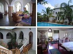
After local administrative offices moved to Mtwara in 1947, Mikindani's fortunes declined. However, the town has since seen an increase in prosperity over the past decade, starting with the renovation of the boma as a hotel in the late 1990s.
Today Mikindani is a fascinating old town with winding streets and an interesting blend of local and Arabic influenced architecture with roofed terraces, sculpted doors and thick coral stone walls. Arab buildings from the 17th century still stand in the town today, though most buildings were erected during the first half of the twentieth century in the old Swahili style. It has a small number of hotels, bars and restaurants, and more recently a yacht club has been founded. It is also becoming known as one of Tanzania's unexplored diving locations.
However, despite these developments, the majority of the population exist on subsistence farming and artisanal fishing, selling a small amount of their surplus.
The town is predominantly Muslim although there is a sizable Christian population.
Images of Mikindani
-
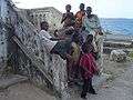
Boys in Mikindani
-

Street with Livingstone House (right)
-

Street scene with cyclist
-

Livingstone House
-

Plaque on the Livingstone House
-
Quiet street in central Mikindani
-

Mikindani Bay seen from the Old Boma Hotel
-
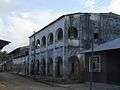
Mikindani former slave market
-

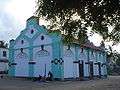
Colonial style building (school?)
-
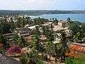
View over the town
External links
Coordinates: 10°16′48″S 40°06′41″E / 10.28000°S 40.11139°E