Military Ridge State Trail

The Military Ridge State Trail is a 40-mile (64 km) long, recreational rail trail in Wisconsin.
It connects the following communities:
It parallels U.S. Highway 18 and U.S. Highway 151.
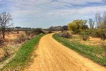
The crushed limestone-surfaced trail runs along the southern borders of Governor Dodge and Blue Mound state parks. The land around the trail is primarily agricultural, but also includes woods, wetlands, prairies, villages, and small cities.
The limestone-surfaced trail is open to hikers, bicyclists, and wheelchair users in late spring, summer, and fall and snowmobilers and cross-country skiers in the winter. The segment between Verona and Madison is blacktopped and also usable by in-line skaters.
The trail receives its name from Military Ridge Road, built by the Army in 1835 to connect Green Bay and Fort Crawford (Prairie du Chien) via Fort Winnebago (Portage).[1][2]
Most of the trail follows the former Chicago and North Western Railway corridor, which has a grade of only 2 to 5 percent. Between Dodgeville and Mount Horeb it runs along the top of the Military Ridge, the divide between the Wisconsin River watershed to the north and the Pecatonica and Rock River watershed to the south. Between Mount Horeb and Fitchburg, it goes through the Sugar River Valley.
See also
Sources
- ↑ Miscellaneous Dudgeon Monroe Neighborhood History, Retrieved July 24, 2007.
- ↑ The Western Upland of Wisconsin, Wisconsin Online, Retrieved July 24, 2007.
External links
| Wikimedia Commons has media related to Military Ridge State Trail. |